THE SEARCH FOR
GUOLIANG
Story written
by Rick Archer
October, 2009
CONFUSION
ON THE INTERNET
How would you feel if you realized you had directly misled
the entire world as to the location of the Pyramids?
My mistake wasn't quite that serious, but I take
responsibility for accidentally hiding one of China's
emerging tourist attractions from the entire world.
In
Part One
of our story, I wrote that I received an upsetting note from
a Korean man named Suhan. This gentleman correctly
pointed out I had badly misplaced the true location
Guoliang. I was grateful that Suhan was willing to
take the time to steer me in the right direction, but I was
at the same time I was deeply embarrassed at my mistake.
Immediately after receiving this note (October 2009), I went
back to the Internet to double-check the location of
Guoliangcun. The first thing I discovered is
that there is still a lot of confusion on the Internet about
this place and other exotic locations such as China's
Huashan
(a favorite topic of mine).
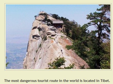 |
For example, I
noticed one website placed China's Mt Huashan over in Tibet.
Look for
yourself. Directly below the picture of Mt Huashan you
will see
"The
most dangerous tourist route in the world is located in
Tibet."
That made me
feel a little better. At least I got the country right when
I made my mistake on Guoliang Village. As for the
Tibet nonsense, fortunately there were many comments listed
directly below the picture that corrected that website's
mistake immediately.
|
| |
Anonymous said...
These pictures are not in Tibet! This is Huashan
near Xian. Thousands of people have climbed these mountains
and only a few sections involve chains and footholds (other
routes avoid these). There is no significant danger here -
it is all in the mind. You should give it a go, it is
character building.
5:46 PM
Evandazzle said...
No that isn't Tibet! That is Hua Mountain in Shaanxi
China! I have been there!
10:17 PM
Scott said...
I have frequent dreams of being stuck on a mountain
path almost exactly like this one. Needless to say, they are
not pleasant dreams.
I am glad that this trail is available for people who
want to climb it. But, have to be completely insane to do
it.
Sorry. It's just the truth.
11:58 PM
Michael said...
Awesome pictures, have always loved to participate
in these adventurous tours but my wife wont let me into
this. Anyways the temptation is too good to resist and I
will definitely figure out ways to escape her and join in
one such expedition. The conventional travel where we relax
on a Holiday home is so boring for me its time for some real
action.
7:14 AM
Linda said...
I'm training for this wonderful trail and plan to be
playing chess on the East Peak within five years.
Not that hard. Just don't mess up.
7:16 PM
Anonymous said...
It's Yellow Mountain in China, just near my
hometown. I've been there quite a lot of times. It's really
amazing!
2:02 AM
Darren said...
This climb is known as the most dangerous tourist route
in the world, its on Mt Huashan located just outside of Xian
in China (NOT Tibet!).
I did this in May 2008.
I have also been along the most dangerous road in China
known as Precipice Long Corridor. This is located in
Guoliangcun.
I also did this in May 2008.
Finally I have also cycled the most dangerous road in
the world known as the Yungas Road located in Bolivia. I did
this in August 2008.
None of these places exist in Tibet!
Hope this settles any confusion.
(Rick Archer's
Note:
Did you
noticed Mr. Crawford hit a trifecta of sorts?
Apparently Darren has visited all three of the
locations I wrote about in my original
Danger story back in January 2007
(Bolivia, Guoliang, Huashan). Not only am I impressed,
I am envious!)
|
|
SERIOUS
INTERNET CONFUSION REGARDING THE LOCATION OF GUOLIANG
|
I Lost It, Now
I Better Find It!
My own mistake
was not quite as serious as placing Huashan a thousand miles
away in Tibet. After all, Hunan Province and Henan
Province are only about 200 miles apart.
Nevertheless,
I was still upset to discover that I had PERSONALLY
contributed to world-wide confusion over the exact location
of Guoliang Village.
You probably
think I exaggerate the importance of my mistake.
In truth, I
honestly believe I was the MAIN REASON that the correct
location of Guoliang had literally disappeared off the face
of the Internet!
As you read this story, you will
see that I write a compelling argument to support my
suggestion that I was the single person most responsible for
losing Guoliang to countless Internet users FOR TWO AND A
HALF YEARS!
|
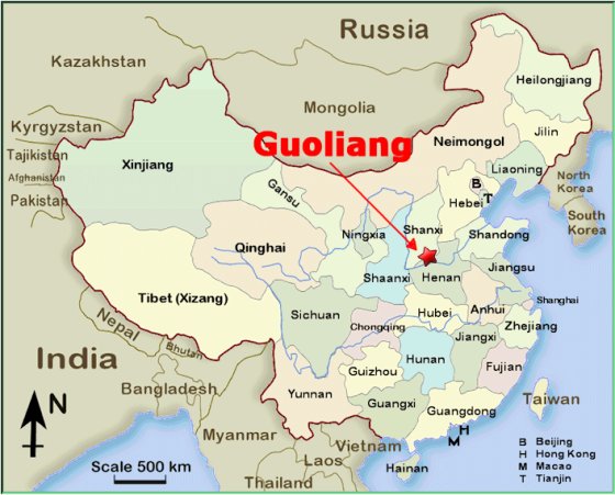 |
A Review of the
Mistake that Started The Search
From:
Suhan
Sent: Monday, October 12, 2009 1:18 PM
To: dance@ssqq.com
Subject: Regarding the Guoliang Tunnel
Hello Mr. Archer,
I've read your site with great interest as I
wanted to travel to Mt. HuaShan. It's definitely a great
mountain, and after my travels, I can attest that it's
not as dangerous as your main article suggests. But I'm
sure you've already received a lot of correspondence
regarding the mountain.
I'm actually emailing you about some
inconsistencies regarding your article about Guoliang
Tunnel. I'm a Korean studying Mandarin in Beijing, and
was looking for other sites to travel to in China.
Of course, I wanted
to check out Guoliang tunnel, but wasn't able to find
it.
It
turns out that the
tunnel is actually in Henan Province,
which is a different province from Hunan (??) as
mentioned in your article. Hunan is more famous for
being the province that Mao Zedong was born in.
Also,
your
map that shows the location of Guoliangcun
is totally wrong too.
You actually marked the star some place in the Hebei
province, though the location of Huashan is correct. I
know this won't be a high priority for you, but it would
be great if you took the time to correct these
inaccuracies when possible.
It would be so
kind if you could identify the exact location on a map.
|
On Tuesday, October 13, 2009, the day after I received Suhan's
letter, I decided the responsible thing to do was find the correct
location and correct my mistake.
The first thing I did was to review my original 2007 article.
That is when I realized I had inadvertently copied someone else's
mistake.
The Mistake
That Started It All
#11 12-24-2006, 05:57 AM
Longstreets
Registered User Join Date: Oct 2006
Location:
Alberta,Canada
"WooHoo !.................mystery
solved!
The mystery
pictures of the Yungas Road in Bolivia were actually
from the
Guoliang Tunnel Road
in
Hunan
Province, China."
|
Okay, so I made a mistake. Two years ago I naively took
someone else's word for it and got burned. How hard can it be
to fix it? I will locate Guoliang and fix my map.
How long will that take, 5 minutes?
Guess what? I expected the search to take 5 minutes.
It took me five days!
I kid you not. It took me three consecutive afternoons to
track down the real Guoliang and two more to write this 2009 story.
Step One - Back to
Google
I began my search for Guoliang by returning to my friend, the Google
Search Engine.
I typed "Guoliang" into Google. Not
surprisingly, I got all sorts of hits. I noticed my own web
site was listed first.
|
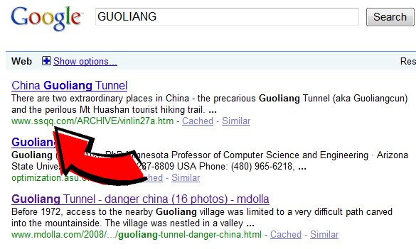 |
SSQQ WEBSITE
IS THE FIRST HIT ON GOOGLE FOR GUOLIANG
There is a
simple reason that Google posts my site first.
Back in
January 2007, I posted the very first web page to thoroughly
document the story of the Guoliangcun Tunnel. This
meant anyone who typed "Guoliang" into Google
came to my page first. The advantage of being the first to
publish is that Google keeps directing people to the page
which in turn guarantees it remains first.
It's the old story of being popular because you are popular.
Everyone assumes you must be popular for a reason, so they
treat you like you are popular. That means you stay
popular.
What I didn't bargain on was that this odd phenomenon would
make me the worldwide authority on Guoliang,
at least where the Western civilization was concerned.
|
|
Let me tell you something... it was a little embarrassing for me to
discover I had accidentally become the worldwide authority on a
place I have never even been to. This doubled my resolve to at
least get the location right!
As I clicked my way down the first and second page of Guoliang
listings, I noticed I wasn't the only one who got the location
wrong. Lots of websites had Guoliang listed in Hunan
Province instead of
Henan Province. In fact, I saw so many websites
agreeing with my Hunan location that for a moment I began to wonder
if I was right and the Korean gentleman was wrong. How could
this many websites get it wrong and just one guy get it right?
Then I noticed something... there was something very odd about every
single web site that agreed with me. They all had the same
pictures as my web site. As I looked closer, I realized they
had the same words too! That's when I realized that
every single one of these websites had copied their material from my
website.
Thanks to
me and a bunch of copycats, each one of these websites had
Guoliang situated in
Hunan Province, not Henan!
I counted a dozen different websites that all incorrectly had
Guoliang placed in the Hunan Province! At that point, I
stopped looking. I was disgusted to see my own mistake had
been magnified many times over.
As it stood,
for the past two and a
half years, the people who had visited my site assumed I knew what I
was talking about.
I had just proven one of my favorite proverbs:
"A
computer can allow you to make as many
mistakes in two seconds as 20 men working for 20 years."
I hope you see the humor in this... I have never visited the place,
I didn't take any of the pictures I posted, and everything I wrote
was borrowed from something else I had read on the Internet.
In other words, I contributed absolutely nothing original of my own
whatsoever. I was simply a parrot echoing the words of other
writers. Yet now I was the worldwide authority. No
satisfaction in that honor, especially when I didn't even know where
the place is!
This situation bordered on the ludicrous. It would have been
funny except that I had misled the entire world as to the correct
location.
I sat at my computer feeling abashed. My error in placing
Guoliang
in the wrong Chinese province had been inadvertently multiplied many
times over. Thanks to me, the entire Internet was having fits
locating this place! In fact, no one even seemed to realize it
had been misplaced. Had it not been for Suhan's innocent note,
I would have never even known my own mistake.
I was responsible for promulgating a stupid mistake across the
entire planet! As you will soon read, many people who
followed in my footsteps made things even worse. I was unable
to find a SINGLE INTERNET WEB PAGE that had the correct location.
The entire Internet couldn't find Guoliang!
I was embarrassed to see my mistake operating like an Internet
virus. Oddly enough, I recalled the Canadian airline attendant
who was widely credited with spreading the AIDS virus all over North
America back in Seventies. Then I remembered the poor kid in
Vera Cruz, Mexico, who was credited with starting the Swine Flu in
2008. Being Patient Zero isn't much fun.
Actually I wasn't the true Patient Zero. I didn't make
the original mistake on Guoliang. I had copied someone else's
mistake without bothering to double-check. That said, I was
definitely guilty of spreading the mistake far and wide. My
frequently-read story was clearly the major origin of the Internet
confusion. My guilt prompted me to do a better
job. But it wasn't turning out to be very easy to do.
How exactly was a man who lives in Texas was supposed to find some
obscure village in a vast and distant country with a language that
was completely foreign?
So on October 13, 2009, I began the search for the correct location
of Guoliang. It was unsettling to see how many people copied
my original mistake, but at least I could understand that. As
I dug deeper, what I found bizarre was that other people who came
after me badly misplaced the true location as well. I couldn't
be blamed for those mistakes. But the mystery was growing
deeper.
Why was the true
location Guoliang so difficult to find?
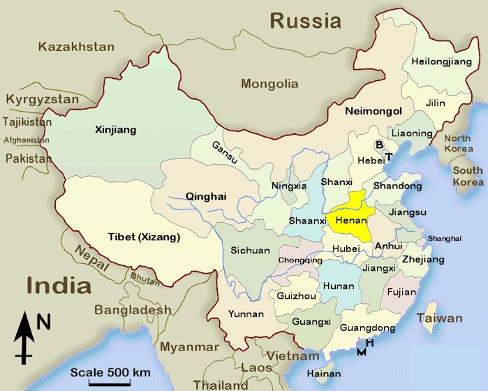
ABOUT THE HENAN PROVINCE OF CHINA
Henan is
China's most important province historically. It sits in the
eastern part of the country in the
central plains region and has the Yellow River
running through it, along with sacred mountains and the
Shaolin Temple.
Henan is the ancient economic, political and cultural
center of China. Henan is the crux
of China's long-running civilization, being home to scores
of emperors over successive dynasties.
It features some of the
most revered temples in the country. Of
its many national parks and scenic areas, Song Shan National
Park and the Yellow River are two of the most visited.
The province of
Henan has several important
historical cities, most of which reside in the center of the
region. Zhengzhou
is the capital and main hub. It is the main rail terminus in
China and is just over an hour away from Beijing by plane.
Other popular cities are nearby Kaifeng
and Xinxiang
plus Anyang toward
the north.
The town of
Luoyang is a couple of hours by train or expressway from
Zhengzhou.
|
 |
 |
Henan is home to the UNESCO Longmen grottoes and
the Ancient Han Tombs Museum and comes with traffic-free
streets and a nice look. Laidback Kaifeng is in the other
direction from Luoyang. It is an hour to the east of
Zhengzhou by expressway and also lies on the Yellow River.
One of the most revered places in China is Song Shan (Mount
Song). It is between and slightly south of the cities of
Zhengzhou and Luoyang are high mountains, Song Shan National
Park, and the vaunted Shaolin Temple. There are stupas
galore here along with monks practicing kung fu.
Gongyi City is also in this general region of Henan and is
known for the Imperial Tombs of Northern Song Dynasty. It
makes a good daytrip from either Zhengzhou or Luoyang and
boasts the restored Yongzhao Tomb.
Heading north of the Zhengzhou area
is the small village of
Guoliangcun
amid the stunning Taihang Mountains. Guoliang
has one of the nicest settings of any inhabited region of
China with superb hiking and climbing options. The hairy
road through the mountains is reason enough for a visit.
|
|
THE
SEARCH FOR GUOLIANG BEGINS
|
 |
|
FORWARD
Rick
Archer
October 2009
You are about
to read a very strange story. It turns out that our
friend Suhan couldn't find Guoliang for a reason - the place
is virtually impossible to find even using a powerful tool
like the Internet! You will have to read the
story to see what I mean.
As of 2009, if you type "Guoliangcun" into Google,
there are over 2,000 hits listed. If you type in "Guoliang",
there are 200,000 hits. Included in these two lists
are dozens of blogs and countless pictures that attest to
the existence of this little village.
However, after
three days of searching in October 2009, I never found a
single map or a set of accurate coordinates for Guoliang on
the Internet.
I am telling
the truth. Nor am I exaggerating. As you will
see, I documented the entire search in a way that allows
anyone to retrace my steps.
That said, you
shouldn't worry about finding Guoliang if you want to visit.
Just go to Xinxiang or Huixian City in
Henan Province and tell someone you want to go visit
Guoliang. There is not only a bus that goes there,
there are plenty of taxi drivers who can find it as well.
Considering all the sites on the Internet created by people
who have visited Guoliang Village, obviously plenty of
people have been able to find their way once they made it to
China.
The true
location of Guoliang (aka Guoliangcun) is a mystery only to
people like me with no access to detailed maps of China.
I am sure this data exists on the Internet somewhere, but I
couldn't find them.
Although I am
getting ahead of my story, I came to realize that
researching a story in a foreign country is difficult if you
don't read their language. So, in a way, my website is
popular because it tells the story to the English-speaking
people of the world. Of course, please understand that
my knowledge is limited. I am sure that some day a
person who speaks Chinese as well as English and who has
actually BEEN to Guoliang will come along and do a better
job.
However, until
that person emerges, I will have to do. I have written
this story for people like me who don't live anywhere near
China (there are currently about 5 billion of us in that
category) and who would like to know the exact location of
Guoliang.
For example, I
live in Houston, Texas, USA. I am an "Internet
Tourist". The Internet is full of people just like me
who fulfill many of their travel fantasies by seeing
pictures and reading stories about far-flung locations by
surfing the Net. My hobby explains the origin of my
own 2007 story about Guoliang. I heard about a strange
place and was curious enough to learn more about it using
the Net. I already had the pictures in an email.
Once I realized how little was known about Guoliang, I
copied material from a half-dozen blogs and combined it to
create an article story about Guoliang. This was a
place virtually no one in the Western world had ever heard
of. At the time, my article about Guoliang helped
generate a lot of interest. I thought I was doing the
place a favor. But I never realized I had misplaced
it!
Of course, the one question everyone asks is "Where in the
world is Guoliang?"
Good question.
When it comes to Guoliang, I have to be honest. This
is the craziest place to find I have ever experienced in my
life! You will just have to read my story to
understand.
GOOGLE EARTH
Before we
proceed, I have a suggestion. If you don't have "Google
Earth" on your computer, then get it NOW. This
amazing service is absolutely free! You will
have the world at your fingertips. No Internet Tourist
is complete without it.
All you have
to do to acquire this program is type "Google Earth" into
Google and follow the instructions. The program
downloads quickly and suddenly the whole world is just a few
clicks away.
Once the
Google Earth program is installed, you will swear it is
something out of science fiction! The stated goal of
the program is to let users "point and zoom to any place on
the planet that a person wants to explore".
|
 |
Using
satellite imaging, you can go see everything from your own
house to the Eiffel Tower, the Pyramids of Egypt, the French
Riviera, Dubai's man-made islands known as "The World",
Mount Everest, the Grand Canyon, and Jerusalem. Google
Earth allows you to check out any place in the world that
you have ever been curious about.
PANORAMIO
PICTURES
One of
the unique features about Google Earth is the growing
inclusion of photographs posted on Google Earth via
Panoramio. This feature allows people who have
actually visited some of these far-flung places to post
snapshots they took of the unique locations.
|
All you have
to do is look for the blue boxes and click. Suddenly
you get first-hand pictures taken by people who have
actually visited the place you are interested in.
Each one of
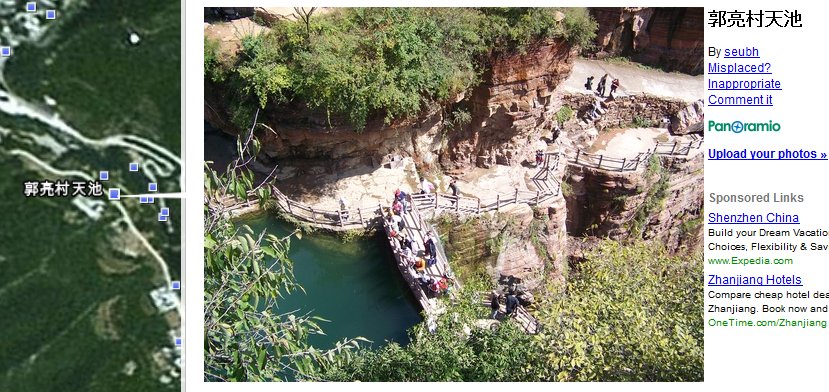
those blue boxes represents a picture. For example,
this picture of a nature preserve at Guoliangcun was taken
by a visitor and posted on Google Earth.
Click on any
blue square (do you see the examples?) and a picture comes
up to look at. It is a wonderful game to visit a place
and use the photographs to see what it looks like. (By
the way, if you find the pictures annoying, you can also
turn them off).
|
 |
Unfortunately,
there is a real game to finding these blue box pictures.
You have to know where the place is ahead of time to see the
pictures. "Close" may count in horseshoes and slow
dancing, but you have to be right on the money to find these
blue box pictures of your location.
Let me see if
I can explain. In the "Furthest Away" position on
Google Earth, it usually takes a dozen clicks to zoom in
close enough for the blue boxes to suddenly appear out of
nowhere. By the way, if you haven't downloaded Google
Earth yet, go get it! This entire article will
be three times more fun if you follow my story on Google
Earth. You will be able to go see those blue dots
yourself. If you have access to the Internet, you have
access to Google Earth.
Normally the
blue boxes are invisible unless you are at a very close
distance. In order to find these pictures by luck, you
have to move around a general area, take a guess, then
carefully zoom in. Once you hit the exact resolution,
out of nowhere, the boxes appear as if by magic.
During my search for Guoliang, I can't tell you how many
times I zoomed in and out of the Taihang Mountains in China
looking for the darn place.
However, the
neat part of the search is I found myself learning about
areas of China that I never knew existed. Although I
was always frustrated by my mistakes in locating the elusive
Guoliang, I loved roaming around "virtual China" thanks to
this remarkable tool.
If you really
want to enjoy the Search for Guoliang story, I hope you will
go download Google Earth. I predict you will have a
ball trying to find Guoliang just like I did!
Here. I am going to make it easy for you. Click the
icon: Google Earth
Now go get it! Come back when you have it
downloaded.
|
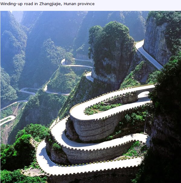
Note: This road
is in a difference province than Guoliang. I found this
picture by accident as I roamed around China looking for
Guoliang. I clicked a blue dot and look what popped
up! China has all kinds of cool things to see.
|
|
Guoliang Dead
End Number One
|
 |
First Try - Wrong
Guoliang #1
For my search, I had three tools - Google, Google Map and Google
Earth.
I was feeling lucky. So I tried typing "Guoliang coordinates"
into Google. So much for feeling lucky. Nothing came up.
After some digging around on Google, I did accidentally run across a
site that listed the coordinates as part of a photograph. I plugged
the coordinates into Google Earth. Although I was directed to
China, I found absolutely nothing to indicate I was in the right
place.
This was just the first dead end in a whole series of blind alleys.
When it was all over, I had spent three entire days looking for
Guoliang!
|
For my second
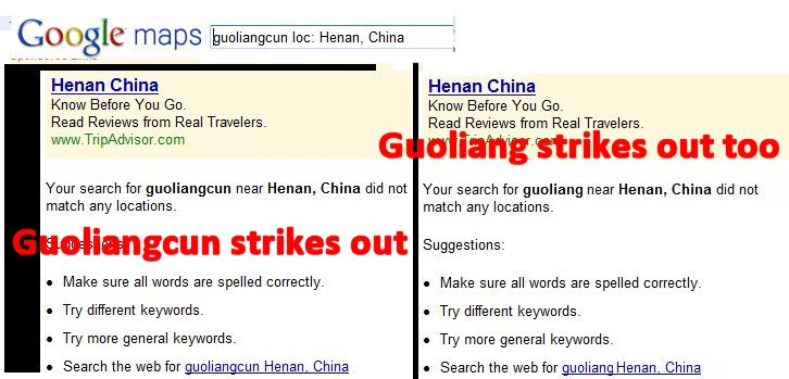
move, I tried using the search engine for Google Maps.
Nothing came up.
As you can see
for yourself, I struck out on both Guoliangcun
and Guoliang as well.
Please note I was in the map for Henan Province, but to no
avail.
|
 |
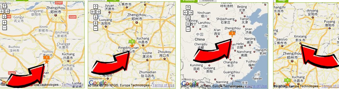
For my third move, I started poking around some Internet travel
websites that specialize in China. Many of the sites came up
empty when I typed in "Guoliang", but one travel website with the
name Gecko had a list of 500 places to visit... and Guoliang was one
of them. Not only that, it had a map!
So I clicked the Gecko link to Guoliang. Unfortunately, every
time I clicked, the map directed me to some spot
south of Zhengzhou, the capital of Henan Province.
That orange "1" is supposed to indicate where Guoliang is. Do
you see something that says "Guoliang" in those maps? No, me
neither.
 |
I was really confused. I had read a Guoliang blog which stated
this:
"I'm
actually writing this from a town called
Xinxiang
which is the closest
train station to Guoliang..."
Looking at the fourth
map above, you can see that Xinxiang is NORTH of Zhengzhou, not
South. Something was wrong here. I decided this map
could not be trusted for an accurate location of Guoliang.
Next I found a description of how to get to Guoliang in a book on "China"
by Damien Harper on Google Books.
Getting
to Guoliangcun (China
- Damien Harper)
It
takes three buses from
Zhengzhou,
followed by a connecting bus to
Xinxiang,
and then a local bus to get
to the base of the cliffs to
Guoliangcun.
Follow the directions from LPG or any other
guide book for specifics
You
can reach Guoli�ngcun from
Xinxiang,
between Any�ng and Zh�ngzhou. Regular trains run
to Xinxiang from Any�ng (Y14, 1� hours) or
Zh�ngzhou (Y13, one hour); buses also link
Xinxiang with Zh�ngzhou (Y24, one hour, every 25
minutes). Exit the Xinxiang train station and
take a motor-tricyle (Y2) to the bus stop 1km
away for buses to Huixi�n (Y4, 45 minutes,
regular).
|
|
Ask the driver to
drop you at the Huixi�n stop for buses to Guoli�ngcun (Y10, 2�
hours, depart 8am and 1pm). Note that buses from Huixi�n may
have the characters for Guoli�ng on the window, but may
(depending on passenger number) only stop at N�np�ng, a village
at the base of the road to Guoli�ngcun. From N�np�ng it is a
steep 3km walk to Guoli�ngcun up the mountain road, otherwise
taxis or local drivers are prone to fleecing (Y40) for the steep
haul into the village, especially if travelers are scarce. In
the other direction, Huixi�n-bound minibuses (Y10) depart from
the bottom of the mountain road from Guoli�ngcun at 9am, noon
and 3pm.
|
After studying this description and giving it much thought, I
decided I still didn't have a strong idea where to find Guoliang
without a map. Guoliang had to be somewhere around Xinxiang.
I could find maps with Xinxiang on it. Okay, that's a start,
but I still couldn't find a single map that showed exactly where
Guoliang was located.
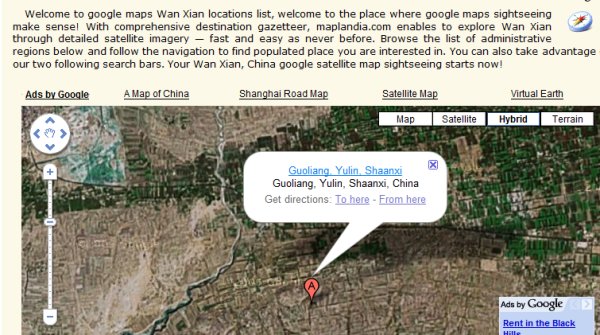
Guoliang Dead
End Number Two
|
Then I noticed another description that mentioned Guoliang:
Nestled away on its cliff-top perch high up
in the Wanxian Mountains in north H�n�n
is this delightful high-altitude stone hamlet. For centuries
sheltered from the outside world by a combin�ation of sheer
inaccessibility and anonymity, Guoli�ngcun shot to fame as the
bucolic backdrop to a clutch of Chinese films, which firmly
embedded the village in contemporary Chinese mythology.
|
So I decided
to explore the Wanxian Mountains. First I went back to
Google Earth. When I first wrote the story back in
2007 , I did not know about Google Earth. As you can
see, since then, Google Earth and I have become good
friends. I typed in "Guoliang" and "Wanxian
Mountains". I immediately came up with a hit!
(see picture)
However, I saw
several problems. First, the area didn't look
mountainous. Second, the location appeared to be in
the Shaanxi Province. Third, the location appeared to be
about 300 miles from Zhengzhou.
Another false
alarm. Back to the drawing board.
|
 |
I was getting
frustrated. As I studied the map, I decided the
Chinese weren't helping very much.
In addition to my original Hunan-Henan mistake, my problems
with Shaanxi Province (see previous picture) made me
notice there was another Province named "Shanxi".
Shaanxi-Shanxi. Hmm. Henan - Hunan. Hmm.
A closer look revealed Hebei Province and Hubei Province.
Hmm. There certainly were a lot of similar names in
Chinese geography! They don't make it easy, do they?
That's when it
dawned on me. Maybe "Guoliang" was a fairly
common name in China. That might explain why I kept
getting hits on Guoliang that kept taking me to the wrong
places.
I searched the
Internet for a detailed map of Chinese cities. Other
than Google Maps which had already turned up empty, I had no
luck.
A few Internet
maps of China listed the major cities, but that was about
it. Finding a map listing the Villages was out of the
question.
|
 |
Guoliang Dead
End Number Three
|
I decided that
Google Earth gave me my best chance, so I went back to it.
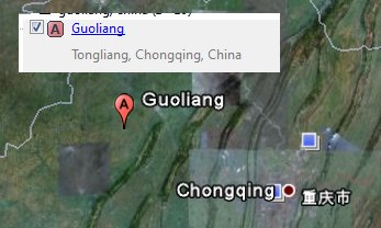
I tried simply
typing in "Guoliang, Henan". To my surprise, I
got an immediate hit (see picture). The problem was,
this location was south of Zhengzhou. After
studying the location, I determined this might be the same
spot the Gecko Chinese Travel Site kept taking me to on my "First
Try".
Good thing
this wasn't baseball. Three strikes and you're out,
yes?
|
 |
|
Guoliang Dead
End Number Four
- I
Discover a Parallel Universe!
|
|
 |
I took another
look at the riddle. An Internet site known as
The Lonely Planet insisted that after Xinxiang, the bus
would take a people to some town named "Huixian".
"Exit the Xinxiang train
station and take a motor-tricyle (Y2) to the bus stop
1km away for buses to Huixi�n (Y4, 45 minutes, regular).
Ask the driver to drop you at the Huixi�n stop for buses
to Guoli�ngcun (Y10, 2� hours,
depart 8am and 1pm)."
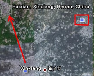
I typed "Huixian"
into Google Earth and was directed to a new spot for my
troubles. (see picture). That cheered me up.
I felt like I was getting closer! Then I noticed
the directions said that Guoliangcun was still 2 1/2
hours away by bus. So near, yet so far. Then I
noticed a curious blue picture box (see picture of blue
square with the red square around it). When I
clicked the box, a picture of Guoliang appeared. Hmm.
I began to wonder if I could find Guoliang by looking at the
blue square pictures. So my new strategy was to wander
around nearby Huixian and click the every single blue square
picture box on Google Earth. This strategy immediately
paid off with dividends. I discovered a real nugget!
|
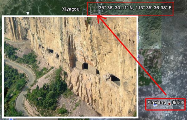
A little
further to the west from Huixian, I clicked on a blue
box which revealed the picture on the right. Now you
tell me - is that Guoliang or not? Of course it is!!!
There are windows and a rubble pile and everything.
Using Google
Earth, I poked around the area for further blue picture
boxes of Guoliang or the name of the village. Nothing came
up but some place named "Xiyagou".
Xiyagou?
The more I
studied that picture, the more confused I got. To be
honest, I had not seen a "Guoliang picture" that matched
this new picture. That winding road was new. Was
it possible that another community named Xiyagou had done
the same thing and carved a tunnel out the mountain?
I don't like
coincidences. Wherever Guoliang was, it had to be
nearby.
So I typed "Xiyagou"
into Google. I was NOT HAPPY with the
results!!
|
 |
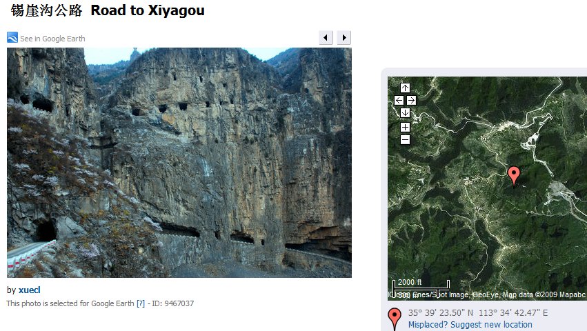 |
As you can see
for yourself, there is indeed a parallel universe here.
These pictures confirmed that I had accidentally stumbled
upon another village in the same mountain region that had
carved tunnels out of cliffs just like Guoliang. Since
Xiyagou started in the Sixties, I suppose this is where
Guoliang got the idea to try the same thing in the
Seventies.
|
Good grief! I was getting pretty discouraged. I was
finding everything but the place I was looking for!
One
thing that bothered me greatly was the possibility that
Guoliang and Xiyagou were the same place.
After all, the pictures of the tunnels sure looked similar
and the location was definitely in the same general area
where Guoliang was said to be. What was going here?
Then I noticed that Xiyagou was listed as being in
the
Shanxi Province
NEXT to Henan Province. I decided that I had
simply uncovered an amazing coincidence between two villages
that no one else to my knowledge had previously pointed out
on the Internet. There must be two different villages with
tunnels carved out of the mountainside.
Rick Archer's
Note: As of 2009, very little information currently exists
on Internet regarding Xiyagou. Here is all that I
found:
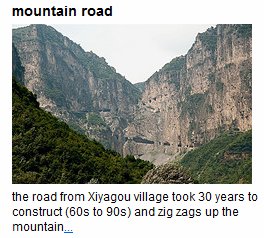
This is a picture of
a road excavated in the cliff of Taihang Mountain in
Pingshun county, Shanxi province, September 2, 2009.
This 1,500-meter (0.93 mile) road took 200 families 30
years to complete and has facilitated movement between
Xiyagou village and other villages of the Pingshun
county, which has often been obstructed by this mountain
range, local media reported.
|
Guoliang Dead
End Number Five
|
|
As I read
various stories about Guoliang, I noticed most of the
bloggers referred to the place as "Guoliangcun". On a
whim, I decided to type Guoliangcun, China
into Google Earth. Nothing happened. Google
Earth didn't budge. So I added "Henan"
into the mix. Boom! I got an instant hit!
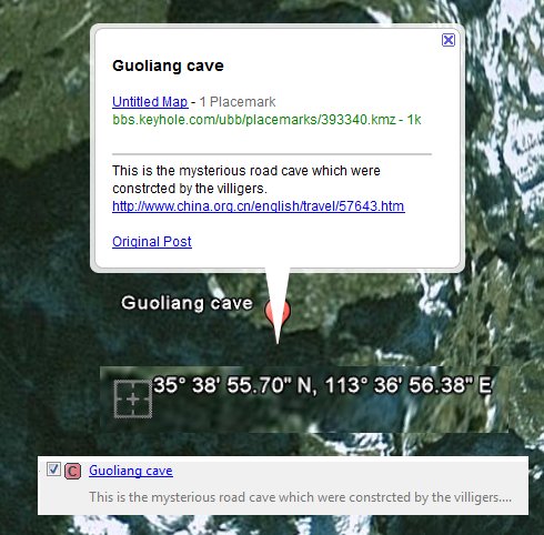
Google Earth rotated swiftly to a town named "Guoliangcun"
(see picture).
Surely this
was it!
There was only problem... I could not find a single blue
"picture" box nearby this spot. In other words, not a
single picture existed to indicate I was in the right place.
No matter how many times I zoomed in and out, no Google
Earth pictures emerged to suggest I was in the right place.
For that matter, no Google Earth images appeared at all.
This could not be the right place. And yet the
blue and red place markers suggested that someone
had clearly marked this spot as special. I recalled
finding some coordinates on a web site that said he had
MARKED Guoliangcun on Google Earth.
Maybe this was the place he was referring to. Unfortunately,
I think he had the wrong spot. There was literally
nothing there.
This
was driving me crazy!! This had turned into a
serious "Where in the World is Carmen San Diego?"
quest. Where was the real Guoliang Village? And
how could I find it?
|
 |
| |
 |
I had just hit
another dead end. I had found four different "Guoliangs".
All four had turned out to be the wrong place.
I had found a
village named Xiyagou that was a near clone of Guoliang and
in the same vicinity to boot, but that hadn't panned out
either.
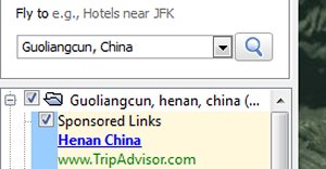
What was my
next move? I noticed there was a sponsored link
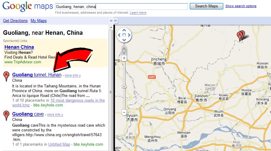
to Henan, China at Trip Advisor. Why not?
|
The Trip Advisor link did not reveal the true location of
the Guoliang Tunnels. However it did suggest a new
place to explore. So I clicked on the link which
directed me to
The Hidden Village of Guoliang, a marvelous story
written by a man named Ernie. I have added excerpts of
his story, but to get the full effect, you need to read the
whole story at "China Expat" and see the wonderful pictures
of Guoliang included in the story.
|
 |
|
The Hidden Village of Guoliang
Written by Ernie
|
In the heart of Henan's Taihang
Mountains lies forgotten Guoliang Cun.
Not entirely forgotten, of course,
in China a "forgotten" destination can officially mean fewer
than ten thousand visitors per day. But far fewer than that
disturb this marvelous relic of rough-hewn splendor, and the
place truly was forgotten long enough that the term applies
more to Guoliang Cun than to most any other Chinese
habitation.
Yet the key feature of Guolian Cun is its inaccessibility.
It sits at a high but by no means vertiginous 1752 meters.
Some eighty families comprising 300
odd people give it life. The clue to the hidden nature of
Guoliang lies in the fact that almost everyone there shares
the surname Shen.
|
 |
In the Yuan Dynasty, the Shen
family were powerful officials in Nanjing. But by the
beginning of the Ming Dynasty, the Shen's glory had run its
course. Emperor Zhuyuanzhang exiled the entire clan to
Qinghai, to do hard labor as punishment for some crime real
or imagined, but certainly lost to the ages. Somehow, most
of the family managed to escape while under guard in Shanxi.
Realizing their odds of getting away were greater in small
groups, they shattered a giant brass wok, the pieces to
serve as symbols of kinship should they or their progeny
ever manage to reunite. Thus did the small band and original
stock of today's Guoliang Cun intentionally take the most
tortuous, untraceable route they could find, stopping only
when they stumbled into an all but impenetrable valley. Here
they consigned themselves to a world entirely apart from the
rest of China. By the 1960s, only one Shen had left to join
the army. The rest, never. The fact that less than ten
percent of Guoliang has more than ten fingers throws some
doubt on the claim (RA
note: what does the writer mean by this?), but
a romantic story is a romantic story.
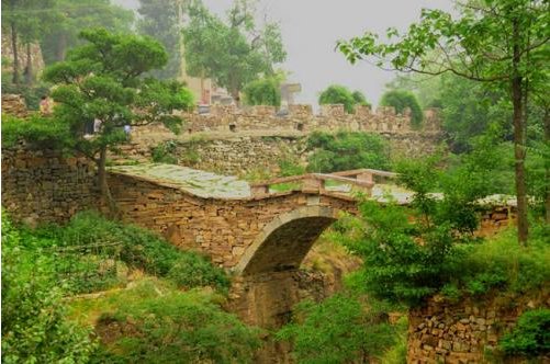
And hey, the place is hard to
reach, even by China countryside standards.
The surest proof of that is the way in, a marvel of
manual engineering. A path carved into the side of the
valley's east cliff face, a three sided tunnel that would
stagger today's average construction firm, is the final
stage of the bumpy mountain journey to Guoliang Cun.
Actually, there was another way in before, one that scarcely
justified being called a path, a goat trail of perilous
drops and ninety degree ascents that guaranteed no one left
Guoliang valley or went in unless under direst need. That
same "path" today is a draw for a breed of deranged hikers
who call a scamper up Hua Shan a "fun day's outing"
(RA note: I think the writer is
referring to the nearby Mt.
Huashan).
Not until 1972 did the residents of Guoliang Cun have either
the desire or the money to round up a bunch of iron hammers
and spikes, a few crude shovels, and get to work carving out
the least forbidding cliff surrounding them. 26,000 cubic
meters of stone they removed in the project, amazing
considering the vertical work site, and the fact that it was
hauled out by hand and bundle. Many died during construction
of this 1250 meter Cliffside loggia, lending merit to its
name Tian Ti, or �Stairway to Heaven' if you like.
|
|
| |
Guoliang Dead
End Number Six
|
|
Just for the heck of it, I went back to
Google Earth and decided to close the program to clear the
places I had already looked at from memory. When I
reopened the program, I simply typed in "Guoliang, China".
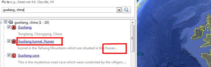
Look what popped up! Now this looked promising.
Except look...
there is
Hunan
back to haunt me again!
How weird is that? It is Henan, stupid,
Henan!!!
Then I remembered that maybe I was responsible for someone
making this mistake. Oh.
|
 |
 |
I clicked the
first link on the list, the one that simply said "Guoliang".
This link took me to Sichuan Province in southern China
which was about 600 miles away from Henan Province.
Nope, this was
definitely not it either. That was the fifth wrong
Guoliang I have been directed to.
However, there
were three links for Guoliang listed above. One of
them was certain to be the one I wanted. Let's try the
second link! The second link said "Guoliang
tunnel".
That had to be it!
|
Guoliang Dead
End Number Seven -
Back to
Xiyagou
|
|
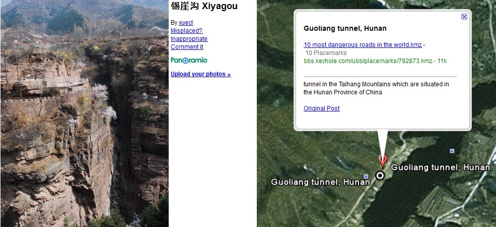
You are not
going to believe this. The second link took me back to
Xiyagou! I clicked the nearest picture and look
what came up!
If you recall,
Xiyagou was the parallel village to Guoliang that was
located in the Shanxi Province (4th Try).
In addition,
the caption clearly says this place is located in
Hunan.
Nope, this isn't the right place.
|
 |
 |
This was my
biggest disappointment by far. This spot was
definitely wrong on two accounts.
First, the pictures clearly identified the place as Xiyagou,
not Guoliang. Second, it was listed in Hunan Province,
but on the map Xiyagou showed up in Shanxi Province.
How could
someone go to all the trouble of place marking this spot and
get it so completely wrong?
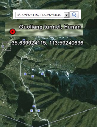
If you
want to go look for yourself, copy these coordinates:
35�38'37.14"N, 113�36'00.83"E (Xiyagou)
(these
coordinates work too:
35.639924115, 113.59240636)
Paste either
coordinate into Google Earth and take a gander.
I believe these are the correct coordinates for Xiyagou.
The actual tunnel in the mountainside is very close nearby.
In the
meantime, Guoliang Village continued to prove very elusive.
Two of the three links have come up empty.
Still, there
were three links. Maybe the last one will be a home
run.
|
|
Guoliang Dead
End Number Eight
|
|
 |
Bad news, the
third link was another strikeout. This was definitely
not the right place either. There was not one
single blue picture box in sight.
The nearest
town was "Mayiti" which was actually fairly close to Xiyagou.
Not only was there nothing to look at in the vicinity, the
location appeared to be in Hebei Province which was north of
Henan Province.
Someone sure
went to a lot of trouble to mismark our destination.
This is the
most ridiculous wild goose chase I have ever been on, but
something tells me I will find this place yet. How I
will succeed I am not sure, but I am not going to give up.
|
Guoliang Dead
End Number Nine
|
|
For my ninth
try, I decided to use a new tactic - brute force.
I had
one clue to go on. One of the blogs I had reviewed
said this:
"The
village is north of
Huixian.
It
lies
up in the Taihang Mountains
right on the border
of the
Henan and Shanxi provinces."
Google Earth
has a mysterious white line. After comparing it to the
maps, I decided the white line clearly marked the border
between the Henan and Shanxi provinces.
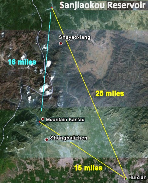
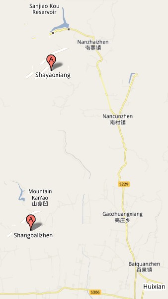
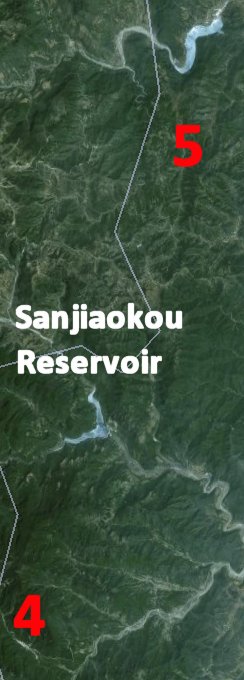
There were two major lakes I used as landmarks. Both
lakes turned out to be major reservoirs, Mt Kanao in
the south, Sanjiaokou in the north. I decided to scan
along the white borderline and see what I came up with.
The picture
seems to indicate a vast distance, but the two bodies of
water are only 16 miles apart. Nevertheless, 16 miles
is vast using Google Earth.
I began a
concentrated search pattern within the suspected area. For
hours I carefully zoomed in and out the entire area between
the two reservoirs looking for clusters of blue picture
dots.
|
 |
 |
I zoomed out
to get the big picture. Then I zoomed in to look for
village names and blue dot pictures.
There were
hundreds of mountains and valleys to choose from in my
Taihang Mountain Range search area. I constantly had to
guess which area to zoom in on. Which valley
might have Guoliang hiding in it? Or what mountain
cliff might contain the tunnel?
| |
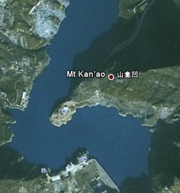
Here is a simple
example. Take the picture on the right. From Google
Earth "Big Picture", I had to zoom in 13 times to get a closeup
of Reservoir on the right.
Note that both a
caption - Mt Kanao - and a blue dot appeared. I
would zoom to get captions, then zoom out to get the big
picture. This process took about 5 hours spread out over
two days.
The distance
from Sanjiaokou to the Mt. Kanao was only 16 miles, but it felt
like I was looking for a needle in a haystack.
Unfortunately I
had tried all my search engines. It was brute force or
nothing at all. |
|
 |
|
Typically, all
I saw was the "Big Picture" like what you see on the right
here. Lots of green mountains plus the helpful
mysterious white line that I assumed was the Henan/Shanxi
Province borderline.
As I scanned,
the names of the villages and blue dots were usually
invisible.
The only way
to see the blue dots and the village names was to stop and
zoom in. It usually required zooming in 13 times
before the names and dots appeared.
It was a crude
and imprecise search technique, but I was convinced that
Guoliang would be surrounded by several tell-tale blue dot
picture squares if I could just zoom in on the right spot.
Slowly but surely, my "zoom in - zoom out" method began to
produce clues.
It took an
entire day of searching, but I eventually identified seven
possible blue dot clusters.
|
 |
|
 |
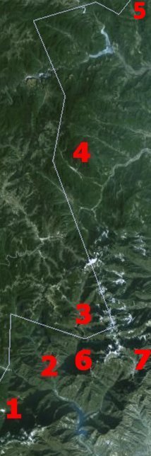
AREA 1
I began my
search in the southern part of my sector around the Mt
Kanao Reservoir. It served as one of my two
reference points throughout the search. By the way, I
never learned exact name of the lake. I named it the
Mt Kanao Reservoir on my own. As I scanned
along the white border, I found my first dot cluster just
west of the Mt Kanao Reservoir
I named it
Area 1. As you can see, there were seven blue
dots. I opened up the pictures.
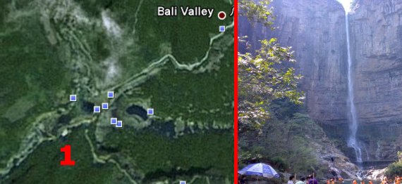
Area 1 turned out to be a lovely waterfall area.
|
|
AREA 2
Area 2
was just north of Mt Kanao Reservoir.
It turned out
to be another lovely waterfall area, but with a much
different look.
These blue
dots revealed many wonderful pictures.
|
 |
|
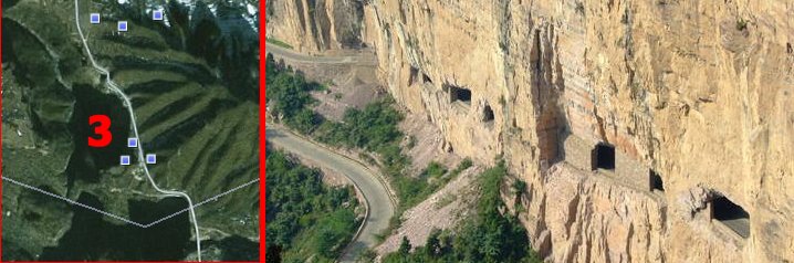 |
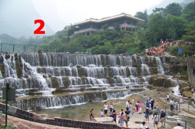
AREA 3
The dot
cluster in Area 3 turned out to be our old friend
Xiyagou.
Note that all the dots in the picture on the right were
north of the border... Xiyagou was in
Shanxi
Province,
not Henan.
|
|
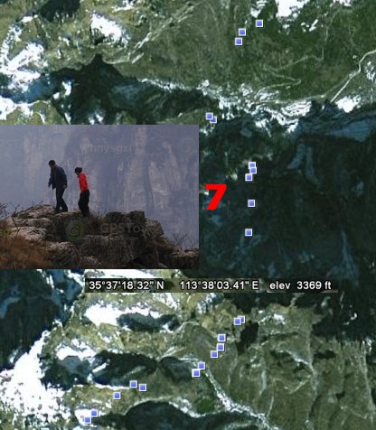
AREA 7
Area 7
was promising. I noticed a large cluster of 15 blue
dots along a line. Alas, when I opened them, I
discovered the pictures were taken by a group that was
hiking across the Taihang Mountains. Boy, I bet
that was a fun trip. These mountains have some really
beautiful scenery.
I enjoyed
looking at the pictures immensely. Even though it
probably seems like I was on a wild goose chase, I freely
admit I had the time of my life exploring this remote area
of the world using Google Earth. I felt like I was on an
adventure of sorts.
Viewing those
Panoramio photos made all the difference in the world.
These snapshots allowed me to get an idea of this exotic
part of the world I was visiting.
Not once did I
feel like I was wasting my time.
If I had one
regret, it is that all the captions on the photographs
were written in Chinese. Maybe if I could have
read what they said, I could have gotten some earlier clues
to help me find our missing Guoliang.
Oh well, can't have everything!
|
 |
|
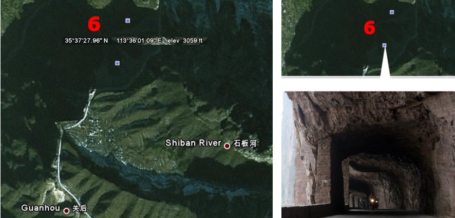 |
AREA 6
At Area 6,
I found two mysterious dots. Both dots revealed
pictures that appeared to be Guoliang.
However, after zooming in and out, I couldn't find any
mention of Guoliang. There was not one village that
popped up. The pictures were just randomly placed in
the middle of nowhere.
However,
finding those dots was encouraging. It made me think I
was on the right track using this brute force method. Surely
Guoliang had to around here somewhere.
|
|
| |
 |
AREA 5
Area 5
broke my heart. I couldn't find what I was looking for
between the original two lakes. So I drifted 5 miles
north of the upper lake, the one that turned out to be
Sanjiaokou Reservoir. I saw a single blue dot.
When I clicked it, the single dot turned into three dots.
All three blue
dots turned out to pictures of Guoliang!
|
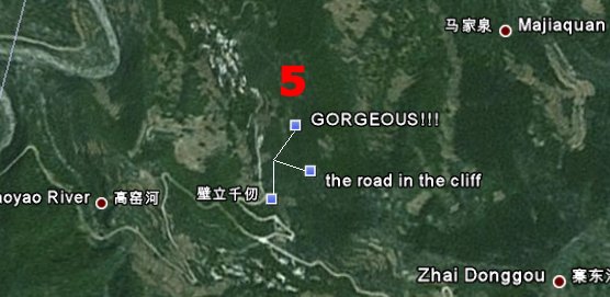 |
There was just
one problem - similar to Area 6, there was not a
single village named "Guoliang" in the area. I only
saw 'Majiaquan', but nothing else.
Area 5 marked the fourth time I had found random
Guoliang pictures. Rather than be discouraged, I was
more convinced than ever the correct location had to be in
one of these valleys. I knew if I just kept exploring, I
would find it eventually.
The problem is that my cursor had to be directly over
an area when I zoomed in for the blue dots to appear.
This was slow going. I moved into my third hour of
looking.
|
 |
|
| |
|
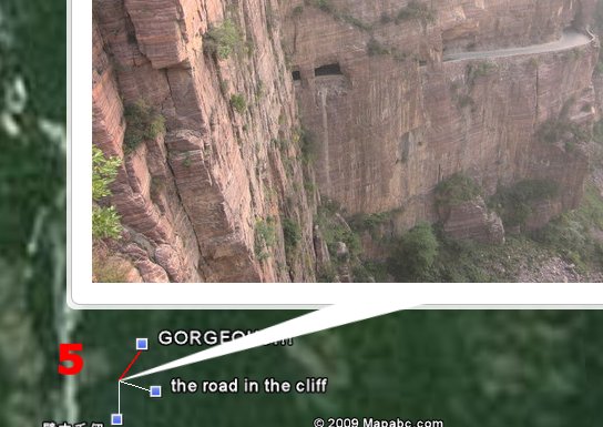
I finally find
Guoliang on Attempt Number Ten!
|
|
 |
| |
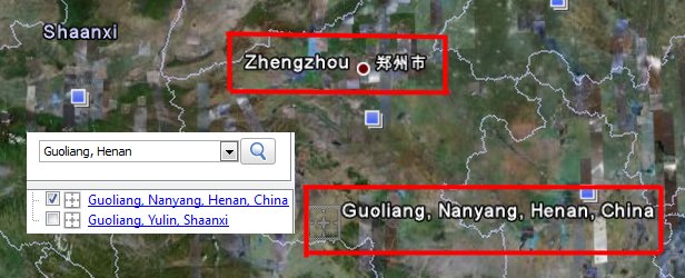
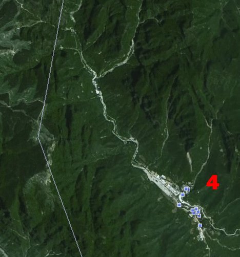
I eventually
gave up on the area north of Sanjiaokou Reservoir.
Moving back south, I saw a valley and zoomed in.
I saw a cluster of blue dots I had not noticed before.
As I zoomed in, out of nowhere the word
Guoliangcun
jumped up. OMG!
I immediately clicked the
Blue Dots
in the
Red Box. |
|
|
 |
Look at the three pictures below. Every one of them
was a picture of Guoliang! But I had seen
pictures of Guoliang before. What made this
different was the name of the village had popped up as well.
This was definitely the right place. My search was
over. I had finally found the real Guoliangcun.
|
 |
|
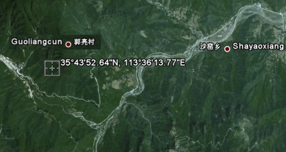
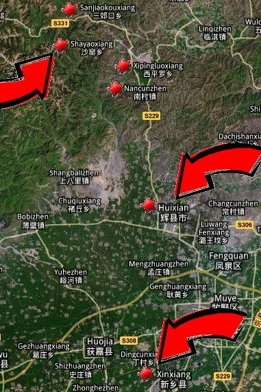
For the record, the correct coordinates
for Guoliangcun are
35�43'52.64"N, 113�36'13.77"E |
If you enter
these coordinates into Google Earth, it will take you
straight there.
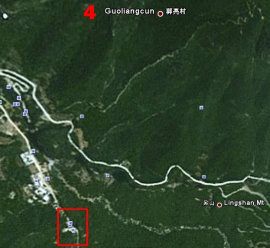
By the way,
take note of the village in the map named
Shayaoxiang.
It is the largest village near Guoliang. It appears on
several maps of China, including this Maplandia photo
on the right.
|
 |
Just for fun,
I typed "Shayaoxiang, Henan, China" into Google Maps.
I was amazed to see the screen take me straight to the right
place.
Then I looked
around. Guess what I found just down the road from
Shayaoxiang? There is Guoliang!
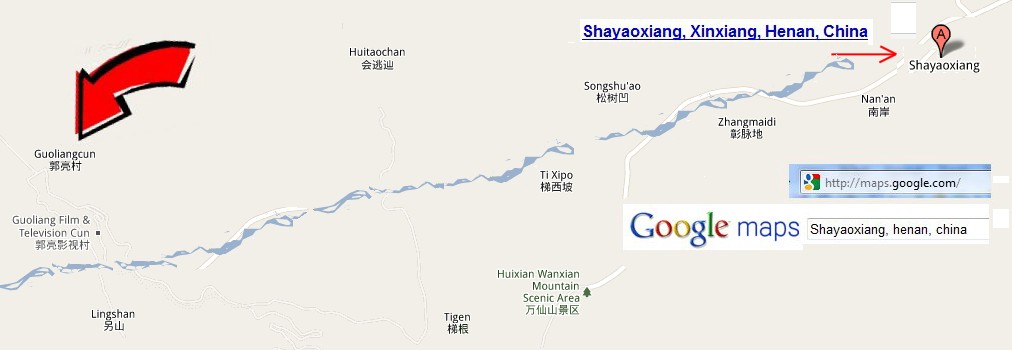 |
Guoliang
is less than a mile from the Henan-Shanxi border. It
is nested on the rim of a cliff. Down in the valley
below, a gentle stream connects to an unnamed river that
flows east through Shayaoxiang. If you can get
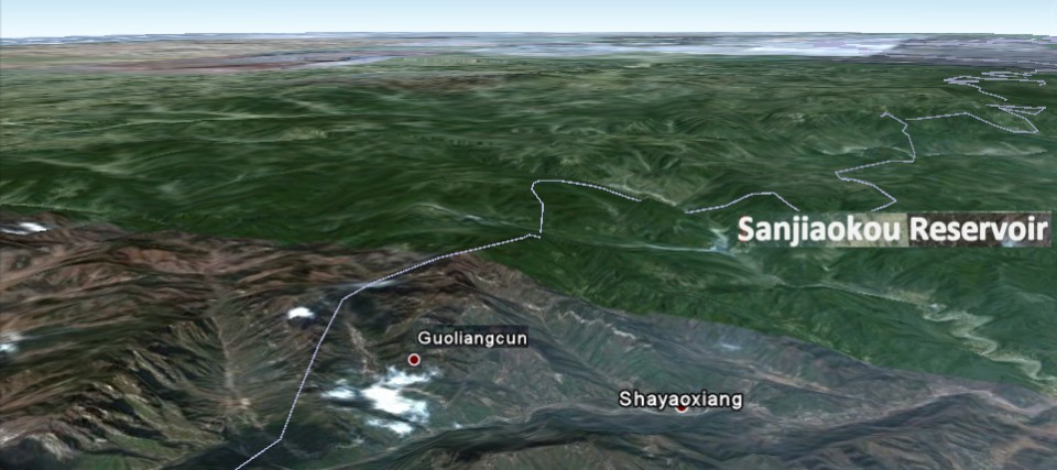
in a helicopter, the Sanjiaokou Reservoir is only 6 miles to
the northeast.
|
 |
|
The good news is that iyou can actually find "Guoliang"
yourself on Google Maps.
Just type in "Shayaoxiang,
henan, china"
and watch it go to work.
On this map
Point A is none other than our old friend Xiyagou
(A), the village with a different mountain tunnel. To
refresh your memory, Xiyagou was the dead end on my
4th try.
Gouliang
(B) nearby just on the other side of the Shanxi
Province Henan Province borderline.
Although
Guoliang and Xiyagou with their matching tunnels
are in different provinces, I later discovered that they are
actually only 6 miles apart!!
Xiyagou is 6 miles SSW of Guoliang "just across the county
line". Or 10 Kilometers if you prefer.)
|
 |
| |
|
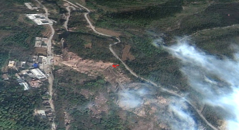 |
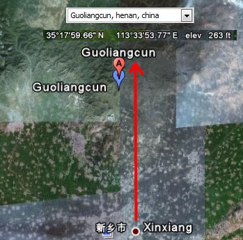
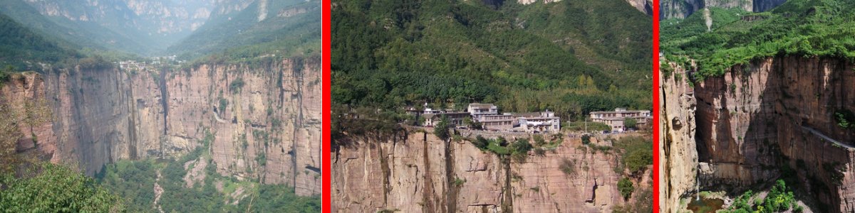
In June 2011,
I took another look at Guoliang. I noticed that Google
Earth had added a 'three-dimensional' feature. I
believe I was able to spot the sheer cliff.
Look for the
small red arrow. I believe that is the spot where the
road suddenly disappears into the tunnel.
It also looks
like there is a very modern road up at the top. From
some of the more recent pictures I have seen, Guoliang seems
to be growing into popularity.
It couldn't
happen to a neater place.
|
I noticed that Google Maps still doesn't lock in "Guoliang"
like it should, but if you type "Shayaoxiang" you
shouldn't have any trouble finding it.
I now am
fairly certain the distance between Huixian and
Guoliang is 27 miles, but I cannot imagine any tour bus
negotiating those steep hills and twisty roads in less than
an hour and a half. The distance from the Henan
Province capital Zengzhou to Guoliang is 100
miles.
It was very
difficult to locate this place originally since I can't read
Chinese, but I can't imagine having any trouble finding
Guoliang once you are in China. Nevertheless I have
some maps that you are welcome to download.
|
|
|
|
MAPS TO
GUOLIANG
During my
three day search for the real Guoliangcun, I created several
maps similar to the one above to help me get oriented (small
joke).
In addition, I
collected a vast amount of additional information about
Guoliang you will certainly find interesting. One
thing I find very amusing is that Guoliang appears to have
gained a "Film and Television" department which appears on
updated maps. I have a hunch pretty soon the world
won't need me anymore to find this place.
At this point,
I am so certain of the location of Guoliang, I honestly
believe I could rent a car and drive there myself. If
you are planning on visiting Guoliang, you will probably
find the maps I have provided very useful. These maps
are so accurate, I bet you could drive there too!
GUOLIANG
MAPS
Thanks for visiting!
Rick Archer
July 2011
dance@ssqq.com for
comments
|
Our Next
Story: The Incredible Huashan Hiking Trail
in China
|