The Guoliang Tunnel
(aka the Guoliangcun Tunnel)
Written by Rick Archer
SSQQ Dance Studio, Houston, Texas
First Published: January 2007
Last Update: October 2009
|
 |
|
FORWARD
Rick Archer's Note: Here on my
website, I have told the stories of two extraordinary places in China - the precarious
Guoliang Tunnel
(aka the Guoliangcun
Tunnel) and the
perilous
Mt Huashan tourist hiking trail.
By the way, Guoliang is also known as Guoliangcun.
In Chinese,
"cun" means "Village", i.e. Guoliangcun is the Village of
Guoliang.
I first learned of these places in
an email sent to me
by Milt Oglesby in
December 2006. The email was titled "Road of Death".
That was one time when the hype did not surpass the reality.
That truly scary road turned out to be located in Bolivia
and it turned out to be a real life killer.
|
The original email contained 23 pictures. The more I looked
at the pictures, the more confused I got. Some of the
pictures did not look like they belonged together. After visiting the Internet to learn more about the "Road of
Death", I realized the "Road of Death" email had
15 authentic pictures of the frightening narrow road running
along the side of a vast cliff (Bolivian
Road of Death), but it also had 8 pictures did not
match the others. Curious, I started to nose around the Internet.
While I researched the dangerous road in Bolivia, I realized
there had been a mistake. Someone had incorrectly mixed
in 8 pictures of a
little-known location in China called the "Guoliang
Tunnel" along with 15 correct pictures of the Bolivian
road. I suppose someone mixed them together to make the truly dangerous Bolivian road seem even
more scary! I smiled. If you have seen the
Bolivian pictures
you will
understand that the Road of Death doesn't require any help
making it look dangerous!
I wasn't the only one who was confused. Back in 2006-2007,
this email was so sensational that it was forwarded all over
the world. Understandably, lots of people picked up on the
discrepancy. This mistake caused a huge Internet flurry as people identified a hoax in the making.
At the time, even Wikipedia
Encyclopedia had a comment on the confusion.
Read some of the comments I ran across.
|
 |
COMMENTS REGARDING THE 2006
ROAD OF DEATH EMAIL
 | "I see that
someone has taken these tunnel pictures and totally mislabeled
them.
They are showing up on many sites as "Stremnaya
Road", the "Road Of Death" situated in Bolivia.
I believe this tunnel carved out of the mountain side exists somewhere in China. |
|
There is definitely a road in Bolivia called the "road
of death", but it isn't called "Stremnaya".
I
don't where they came up with that name. The correct name
is "Yungas Road"... it gets its
'road of death' nickname because of the
high number of fatalities on it each year.
|
|
But its
appearance isn't anywhere close to this beauty that
appears to be in China.
|
|
I have tried to find out more information about this
road in China and the closest pictures I can find that resemble
this terrain is the Leshan Giant Bhudda. Does anyone have any more information about this place?
Thanks. Rob"
|
|
10-09-2006, 02:22 PM
Trantor
Registered User Join Date: Feb 2004
Posts: 2,519
"It was me
who posted it as 'Stremnaya Road, Bolivia'. All I
did was
copy the email. The thread is still on first page. I
received the pics labeled as that. But in the
thread I already admitted some of the pics could be elsewhere, but all
my google searches labeled it as being really in
Bolivia, sites in english, german, etc.
This may just
prove that hoax emails travel faster than light or even
tachyons!"
#11 12-24-2006, 05:57 AM
Longstreets
Registered User Join Date: Oct 2006
Location: Alberta,Canada
"WooHoo
!.................mystery solved!
The mystery pictures of the Yungas Road
in Bolivia were actually
from the
Guoliang Tunnel Road in
Hunan Province, China."
THE
MISTAKE I
DIDN'T CATCH
Rick Archer's Note:
In the space of just three emails above, there were
three big mistakes.
Mistake One was mixing the Bolivian pictures in with the
Chinese pictures. That one was easy to catch.
The second mistake was identifying the dangerous road in
Bolivia as "Stremnaya" when the accurate name was indeed "Yungas".
These "Road of Death" mistakes in the original email actually worked to my advantage.
I was really curious about the mystery of the mixed-up
pictures. While I was researching the email
containing the mislabeled pictures back in January 2007, not
only was I able to discover the great story of China's Guoliang Tunnel,
but I also ran across the incredible story of the
Siberian Highway of Mud.
Unfortunately
I didn't catch the third mistake. The Guoliang Tunnel
was actually located in the Henan Province of
China, not the Hunan Province.
The source of
my original mistake is obvious. Back in 2007, I took a
statement I read on the Internet and accepted it as fact.
Read for yourself.
The mystery pictures of the Yungas Road
in Bolivia were actually
from the
Guoliang Tunnel Road
in
Hunan Province, China."
On October 12,
2009, I received an email from a Korean gentleman named Suhan that pointed our my error. Once I checked,
to my embarrassment, I discovered Suhan was right and I was
wrong. Uh oh.
Here is the
letter from Suhan:
From:
Suhan
Sent: Monday, October 12, 2009 1:18 PM
To: dance@ssqq.com
Subject: Regarding the Guoliang Tunnel
Hello Mr. Archer,
I've read your site with great interest as I
wanted to travel to Mt. HuaShan. It's
definitely a great mountain, and after my
travels, I can attest that it's not as
dangerous as your main article suggests. But
I'm sure you've already received a lot of
correspondence regarding the mountain.
I'm actually emailing you about some
inconsistencies regarding your article about
Guoliang Tunnel.
I'm a Korean studying Mandarin in Beijing,
and was looking for other sites to travel to
in China. Of course, I wanted to check out
Guoliang tunnel, but wasn't able to find it.
It turns out that the tunnel is actually in
Henan (??) Province, which is a different
province from Hunan (??) as mentioned in
your article. Hunan is more famous for being
the province that Mao Zedong was born in.
According to Lonely Planet, the
tunnel was built by a local man called Shen
Mingxin and others, before which the only
way into the village was via the "Sky
Ladder" - Tian Ti (??). Both are attached to
the "Precipe Gallery" - Juebi Changlang
(????). You can verify the information by
looking at p.469 of the 11th Edition of
Lonely Planet China. (Different versions
should have different page numbers, but look
for Guoliangcun). The village apparently
became famous after a few movies were filmed
there.
Also, your
map that shows the location of Guoliangcun
is totally wrong too.
I
know this won't be a high priority for you,
but it would be great if you took the time
to correct these inaccuracies when possible.
It would be so kind if you could identify
the exact location on a map.
I hope your dance studio is doing
well in this bad economy. I also definitely
hope that you visit China some day. It's a
beautiful country with some amazing scenery.
Regards, Suhan
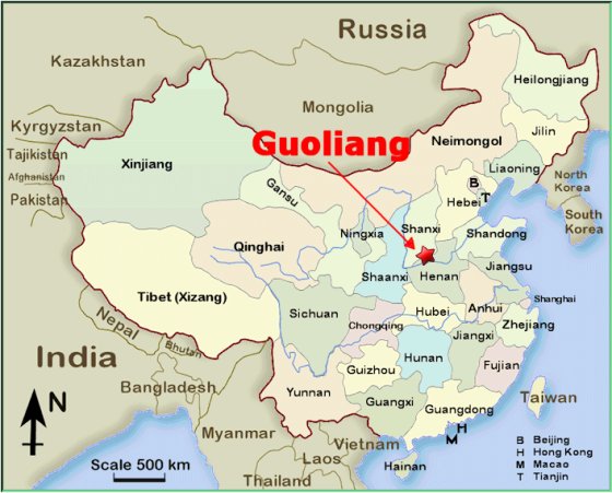
Rick
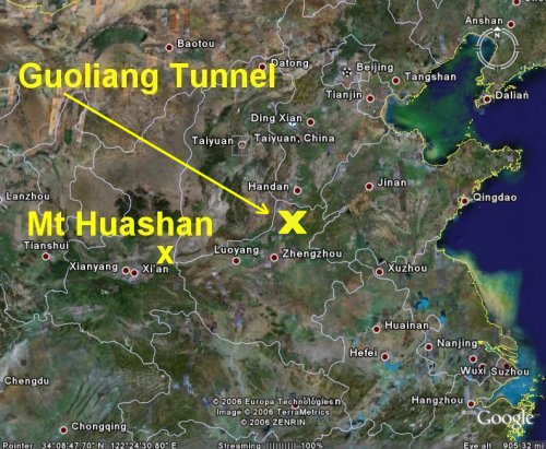
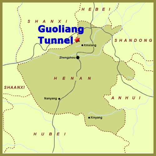
Archer's Note: Suhan was indeed correct.
I have now changed the original map. Please note
the new (and correct) location.
|
ORIGINAL
INCORRECT MAP (2007) |
|
UPDATED
CORRECT MAP (2009) |
|
|
|
|
|
THE STORY
OF THE GUOLIANG TUNNEL |
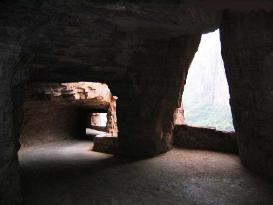
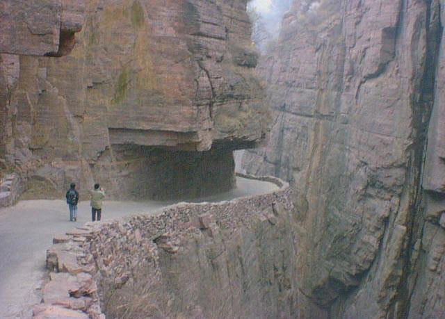
Can you see the steps?
Notice
the distance to the valley below!
 |
| |
 |
|
Guoliang Tunnel
(Rick Archer's Note:
I
have never been to China. I have based this
report on stories I have culled from the Internet.
If you have been there and read any inaccuracies, by
all means contact me at
dance@ssqq.com
Thanks!)
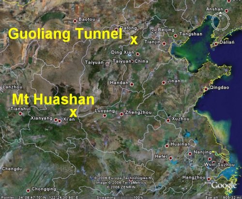
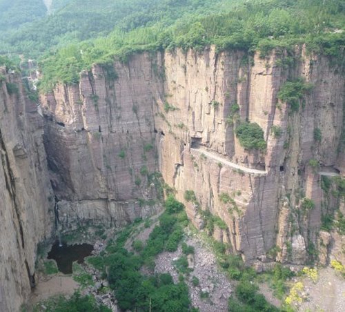
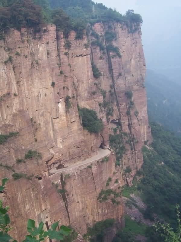
The Guoliang Tunnel is located in the Taihang Mountains
of China. The little village of Guoliang is
situated in the northwest corner of the Henan
Province.
There is an interesting
story about this tunnel that makes it pretty special. Before 1972,
access to the nearby Guoliang village was limited to
a very difficult path carved into the mountainside.
Apparently the village is way way up on a mountain.
The only way to reach it was to travel through
valley surrounded by towering mountains, then climb
the Sky Ladder.
"The
community is approximately 300 people.
It was unreachable to the outside world
until a road was blasted into the cliff side.
The village sits
atop the cliffs and provides views of the
surrounding area.
There are many places to walk and explore in the
village and surrounding
area."
Guoliang was basically cut off
from civilization. For one thing, it was
extremely difficult to bring supplies in and out of
the village. Communication was another problem
- there were no telephones. Furthermore, there
is a possibility there was no electricity
either. Cut off from the world, the village
was little better than a medieval hamlet.
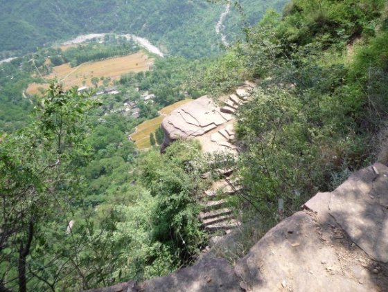
The picture on the left shows the steps used to
climb from the valley to the village high above.
Having been to the State of Colorado here in the
USA, I know that most mountain roads and railroads take the
path of least resistance alongside rivers that cut a
path through the mountains. I am
guessing that back in the Seventies there was a
serviceable road that went through the valley down
below in the Taihang Mountains. However, there was
absolutely no way a road could be constructed from
the valley to the top using conventional methods
unless the Chinese government was willing to blast a
road out of a sheer cliff... which it wasn't.
The village seemed doomed to live in the Land that
Time Forgot.
1972, a group of desperate villagers decided to take
matters into their own hands - they would carve a
modern road right into the side of the mountain all by
themselves! Shen Mingxin was the head
of the village at the time. He insisted
that the villagers needed to embrace this project as
a way to connect to the vast world beyond.
So the villagers sold goats and herbs to buy hammers
and steel tools (and maybe some
explosives?). Thirteen strong villagers began the
project. It took them six years to finish the
1,200-meter tunnel (a little
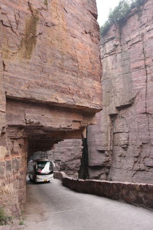
less than a mile). The tunnel is basically a
one-way road which is about 5 meters
high (15 ft) and 4 meters
(12 ft) wide. It is
wide enough for two vehicles to pass.
Not only was the project arduous,
it was also dangerous. Some of the
villagers died in accidents
during construction. Undaunted, the others
continued.
On May 1, 1977, the tunnel
was opened to traffic. For
the first time, cars could now reach the village.
|
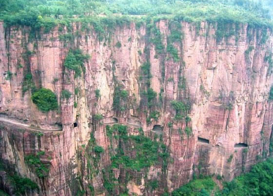
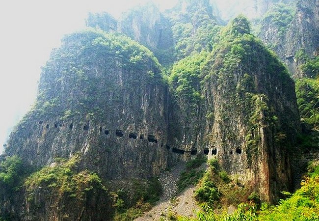
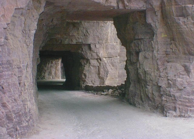
Here in Guoliang, you can see areas where
they created an open air ledge. Think
how difficult it would be to blast a
complete ledge out of the side of this sheer
mountain. The tunnel is actually a
pretty clever idea. By creating a
tunnel, they didn't have to blow away half
the mountainside to create a continuous
ledge. There are more than 30 windows.
The men carved the windows mainly as a way
to push the rubble out.
When I first
wrote this story back in 2007, very little
information was available about the events
of the Seventies. Think about it for a
moment. Can you imagine carving a
mile-long tunnel out of hard rock using only
hand tools? Surely they used
explosives, but did they have training?
This might explain why there were fatalities
during the construction.
When I wrote my 2009
update on Guoliang, I noticed there is now
quite a bit of new information on the
Internet about this village. Thanks to
Westerners who have visited and posted blogs
of their journey, this place is almost
famous now!
If anyone has more
information on the creation of the tunnel
and would like to share it, please email
dance@ssqq.com
and share. Thanks! Rick Archer
|
 |
|
|
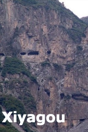 |
By the way,
in addition to Guoliang, there are two other nearby mountain
tunnels.
Xiyagou
pictured on the left lies 5 miles due south of Guoliang.
Kunshan
pictured on the right lies 2 miles to the southwest of Guoliang. It
is within walking distance of Guoliang.
For
the complete 2011 story of these two tunnels, click here:
Kunshan Xiyagou
|
 |
|
| |
Video of the Gouliang
Tunnel
From:
david goorney
Sent: Sunday, November 21, 2010 10:35 AM
To: dance@ssqq.com
Subject: GUOLIANG tunnel China
Hi
there, enjoyed reading your web page on the Guoliang tunnel in
China, thought you might like to see this video I made of the famous
tunnel.
Hope
you enjoy. David Goorney
Guoliang Tunnel Video
|
|
| |
CIVILIZATION VISITS
THE LAND THAT TIME FORGOT
|
 |
Here is a writeup from a Chinese Tourism
Website:
Turning to the north, we now come to
the Taihang
Mountains in Huixian County. The local government has explored
several scenic spots to develop tourism, among which the most
attractive were Guoliang Cave with its red mountains (exposed red
shale).
Local villagers cut a tunnel road through the mountain and
named it Guoliang Cave.
Before the construction of the tunnel, Guoliang Village was almost
cut off from its surrounding towns and villages. A dangerous ladder
on the side of a precipitous cliff was the only route in and out of
the village.
Today the situation has totally changed. Guoliang Village has become
a pearl of Taihang Mountains because of its unique scenery and stone
buildings.
As you can see from the Tourism recap, this story has a happy
ending. The villager's incredible gamble paid off in a big way.
Around the year 2000, China began to open its borders to the
rest of the world. The government decided the benefits of tourism
outweighed the disruption of having outsiders tromping around the
countryside. When government officials visited this area, they decided
the unusual tunnel and the beautiful surroundings made Guoliang a perfect tourist attraction.
Suddenly the little
village that had been once cut off from the world had thousands of
visitors from every part of the world! In fact, as of 2009,
there are hotels being built in the village itself to accommodate all
the visitors. The area itself has become a national park of
sorts. There are modern walkways and bridges constructed so
people can wander all over the area.
|
|
| |
|
 |
Mind you, this work was done by 13 untrained
villagers who had to trade practically every animal they owned to
buy modern tools.
They had no idea how their gamble would pay off. For
five years, they labored. Nor could they tend to their farms very
much while they worked. In poker terms, this is called "Going
All In."
The villagers literally bet the farm on this project!
I doubt seriously that Hollywood has ever heard of this place, but I
can imagine the story would make for a very interesting movie.
I remember a goofy 1995 Hugh Grant movie The Englishman Who
Went Up a Hill But Came Down a Mountain. The movie was
cute, but kind of lame.
My point is that if someone can make a film
like that, then Guoliang's compelling story should be fair game.
The story of Guoliang's tunnel is definitely a tale of bravery,
gamble and sacrifice.
|
|
| |
You have to hand it to the villagers.
The moment they opened their tunnel to vehicles, they quickly came
up with a great marketing slogan:
-
The Road that does not tolerate any mistakes
At a glance, this road doesn't look anywhere
near as dangerous as that monster in Bolivia, but on the other hand,
you might notice that open stretch in the side of the mountain.
Maybe there is some danger!
Plus with a road only 12 feet wide, I can't
imagine much two-way traffic either. Maybe it's like rush hour
contraflow... one way in the morning for tourists, the other way in
the evening.
Personally, I doubt there is any danger unless
someone isn't paying attention, but so what?
The story here is the remarkable achievement
of a small group of uneducated, impoverished people taking a huge
gamble so they could join the world.
|
 |
|
| |
 |
I certainly hope those tourists in the picture
are keeping a close watch on
the traffic.
One vehicle coming around the corner a little too fast might take
them out!
It isn't like they have any place to hide from an oncoming car.
I guess they would have to throw themselves against the side of the rock.
Or maybe they could take their chances and jump off the side.
What do you think? Good idea?
|
|
| |
Here is an
excerpt from a writeup I
found on the Internet:
"We chose to go
through the tunnel. Sitting
by the elderly driver I heard the story
about how the tunnel
was created. Before 1972, the
path chiseled into the rock used to be the only access linking the
village with the outside world. Then the villagers decided to dig a
tunnel through the rocky cliff.
When I was mulling over what the tunnel looked like, the van started
a very steep ascent. I looked up and could not move my eyes away -
it was so beautiful!
All of us were excited by the vision.
We found ourselves in extremely gorgeous
surroundings - against the blue sky, with a path
frighteningly narrow, and the cliffs piercing the
sky.
All of my fellow "donkeys" stopped talking; some
were busy taking photos, some were just dumbfounded.
The golden sun shone upon the ground and through the
air vents in the rocky wall of the tunnel. We were
sometimes in the dark and sometimes in the light.
|
|
 |
I was deeply moved
and even wanted to cry, for the sacred Guoliang Tunnel and for what
the villagers have done - to triumph over nature.
In about an hour, the small van slowly took us to
the unsophisticated village surrounded by the
towering mountains.
The village, more than 1,200 meters above the sea level, seemed as
if it had retreated from the world. The
story of Shangri-La crossed my mind.
Everything there was made of stone: the village gate, roads,
bridges, houses, tables, stools, bowls and chop sticks.
It is said
the village originated from Guo Liang, a peasant army leader who
used to fight there in the Western Han Dynasty (206 BC-AD 24).
There are currently about 83 households in the village with 329
people."
|
|
| |
 |
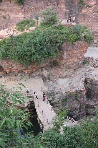
Keep in mind that the Guoliang Village is on
top of the mountain. This tunnel goes upwards to the left as you
view this picture. Here is another look at the open stretch of
the tunnel.
Maybe that slogan about not tolerating any mistakes refers to this
part of the road! Take a look at the
rubble below at the bottom of the canyon. That debris is
likely the remnants of the open area where they blasted out a ledge
rather than continue the tunnel.
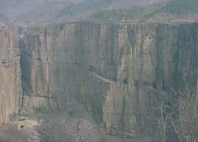
The area is
completely barren of foliage. Most pictures of this same
location have lush greenery visible. This
suggests that the picture was taken during the
construction of the tunnel.
Another reason the area was barren because it was winter time.
Note that many trees in the picture
have no leaves.
|
|
| |
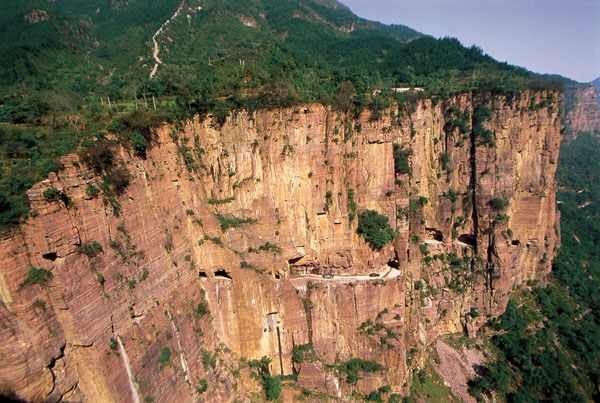 |
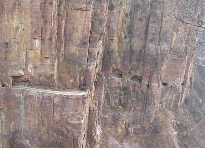
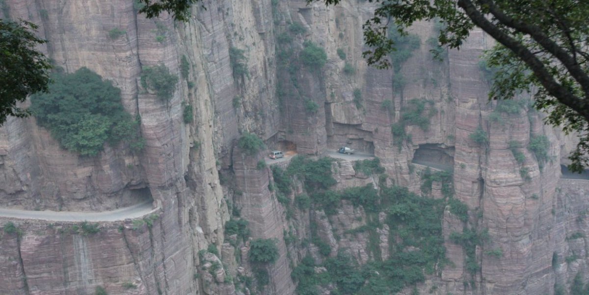
In this picture, you can make out two
vehicles driving on that open stretch.
Too cool.
This picture was likely taken long after the
construction was over.
Notice how much vegetation there is compared
to the picture above of the same spot which is totally barren.
I believe this picture
lends support to my guess that the barren pictures were taken during
construction.
|
|
 |
What is interesting about the
picture on the left is to see how narrow the gorge
is towards the top. I wonder if there is a bridge up
there.
The picture on the right shows how rough the road
is.
In pictures taken down at the
bottom of the valley, the roads are smooth and
modern. Since their village was at the top of
the cliff, the villagers had to find a way to
connect their tunnel to the valley road below.
The narrow stretch in the
picture is likely taken towards the top of the
tunnel. It confirms that chiseling and
blasting doesn't
make for a very smooth surface.
Both pictures indicate the tunnel isn't wide enough
for two vehicles.
|
 |
|
 |
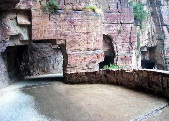
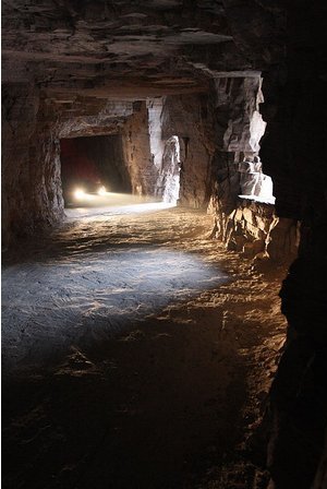
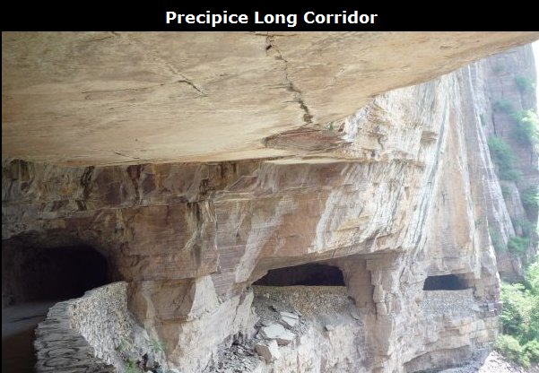
Guoliang Tunnel is different from other road tunnels; it is quiet,
secluded and mysterious, bright one minute and dim the next, full of
twists and turns.
The wall of the tunnel is uneven and there are
more than 30 "windows" of different sizes and shapes.
Some windows are round and some are square, and they range from
dozens of meters long to standard-window-size.
It is frightening to look down from the windows, where strange rocks
hanging above form the sheer cliff and there is
a seemingly bottomless pit
lying below.
Walking through the twisted tunnel is like walking through a
labyrinth as the window light mingles with the shadows inside the
tunnel.
And the stroll can be unsettling - you never know
when the the sound of a motor might
come from behind, sending tourists scrambling
desperately in
search of a safe place.
Considering the primitive
technology used by the villagers, I hope a trained engineer has
taken the time to make sure how safe the tunnel is.
|
|
|
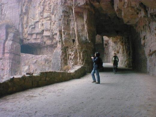
Isn't this a great picture?
Maybe there really is two-way traffic. Those two vehicles
look ready for a head-on collision!
|
|
| |
|
Blogs about
Guoliang
Rick Archer's
Note:
During my 2009
update, I ran across three excellent blogs about Guoliangcun that you might
enjoy reading.
Tofudan
Marizanne and
the excellent
Slide Show
I ran across many other
excellent stories as well. Any Google Search should
gather you all the pictures, stories, and information you
would ever wish to acquire.
The third blog is a
wonderful story written by Darren
who actually
visited Guoliang.
Darren's
story about Guoliang was my favorite.
I wrote to Darren
for permission to reprint his fascinating story.
He deservescredit for
sharing this great story with all of us.
|
From: Darren
Sent:
Monday, March 01, 2010 4:30 PM
To: dance@ssqq.com
Subject: Mt Huashan & Guoliang Tunnel
Hi Rick Archer
I got your email and
did a Google
Search on my name. I
came across your web page since you have a link to my blog.
It was interesting reading all the facts about Huashan, Guoliang and
Yungas (Bolivia) and its nice to see
that my material
helped you publish a very helpful article for others.
|
 |
You are right, when
I purposely ventured out to find these
three places there was much confusion on the internet, no one seemed
to know where they were located. That included half a dozen taxi
drivers and bus terminal reps. It took me a long time to track down
the information and then a lot of patients to actually find these
places (Huashan, Guoliang). It's
nice to see all the info in one place. Good
job, mate!
Thanks for referencing my blog properly, it is much appreciated. I
have been finding copies of my stories and
photos all over the internet without reference. Still its nice to
see people find my blogs interesting.
Maybe I should try publishing some of this stuff myself.
Cheers, Darren
|
Traveling The Most Dangerous Road In China
Written
by
Darren
June 2nd 2008
Guoliangcun was another one of those
small towns that was incredibly difficult to find. We left
Shaolin in the early hours and got on a local bus to Luoyang
and then made our way to the long distance bus station in
Dengfang.
At first we struggled to find the long distance bus station,
because everyone kept pointing us in different directions. I
got the feeling they didn't have a clue what we were asking
and they just wanted to get rid of us. Occasionally we would
approach people for directions that would give us a confused
look and then proceed to run down the road to get away from
us! We found this reaction to our presence hysterical!
We eventually found our way and got on
a long distance bus for a day�s travel. We made our way to
Zengzhou and then caught a connecting bus to Xinxiang.
Unfortunately when we arrived in Xinxiang we soon realized
that we had missed the last local bus to Guoliangcun. We
didn't really want to lose a day in Xinxiang because our
China visa is running out, so the negotiations with taxi
drivers began.
Those Chinese
taxi drivers are a real pain!
|
 |
On The Road To
Guoliangcun
How it looks from inside the roads
tunnels in the arse, they try to fleece you blind. We argued
with a few before we managed to find a reasonable price (try
arguing while using charades - its hysterical). Even then,
we had to trust a taxi driver who we had successfully pissed
off through harsh negotiations to take us to our
destination. We didn't have a clue where we were trying to
get to, if he had dumped us at the side of the road we would
have been screwed. We drove through some very dodgy towns
and yet again I felt an un-nerving feeling in my stomach.
Guoliangcun is a high altitude town
nestled away on its cliff-top perch high up in the Wanxian
(Ten Thousand Immortals) Mountains in northern Henan. For
centuries it has been sheltered from the outside world by a
combination of sheer inaccessibility and anonymity. Until
recently the only way into and out of the town was via a
very dangerous sky ladder up a cliff face high into the
mountains (similar to the ones we climbed in Xian).
Fortunately it is now connected to the rest of the world by
one of the ten most dangerous roads in the world knows
Balancing On The Edge
Hey, its a
long way down! Lucky for us, this was exactly what we had
come to see.
As we approached Guoliangcun we
immediately set sight on Precipice Long Corridor. Our Taxi
driver originally tried to dump us at the bottom of the road
and told us to walk, we refused to get out and made him
drive us up the dodgy road high up into Guoliangcun.
Precipice Long Corridor is an insane
stretch of road carved into the face of a cliff. Its almost
like a tunnel, but with large gaps just large enough for a
vehicle to lose control and fall thousands of meters. The
structure and tunnels within the road don't look very well
constructed. One day I can see the entire thing collapsing,
especially if there is an earthquake!. There are huge cracks
in the tunnels and foundations. Cars whiz up and down the
road without a care in the world. Our taxi driver was
slightly more careful, he wasn't happy we had made him drive
us to the top!
When we arrived in Guoliangcun we
stayed in a converted home stay. Things are very basic with
mind boggling views of stunning landscapes, cliffs and
mountain ranges.
We wondered around the old town while
watching the locals follow a fairly primitive way of life.
Whoever came up with the idea of building a town this high
up in the mountains must have been either insane or
paranoid. Its one hell of a hike. Getting supplies into the
town must have been a nightmare!
We spent some time independently hiking
high up into the mountains. My memory of China is definitely
going to be the million carved steps I have climbed while
hiking high into mountain ranges. I think I will need some
new knees when i return home to the UK. We were told there
was only 4 other foreigners in town. I guess not to many
foreigners make it out this far. Its always a nice feeling
to get off the beaten track.
By the time we arrived at Xinxian we
were exhausted and really didn't fancy the prospect of
getting on a motortaxi to get to a bus stop to take a bus to
get to another bus stop where we could catch a bus to a town
where we could pick up a mini bus which would take us to the
bottom of a 3k hike to the place we wanted to go. When a
taxi driver offered to take us there for about �12 we just
said ok and slept in the back of his cab for the 2 and a
half hour journey. The only thing I really remember about
that journey wasd when the driver didn't fancy paying to use
a toll road he bought a packet of fags and gave it to a
farmer to let him cut across his field. Which was pretty
funny I thought.
A Beautiful girl
We got to Guoliang at about midday and
had to go and take a quick nap in our newly built hotel.
I'll give you a little history about
this beautiful cliff top town. There are around 300
residents and until 1976 it was virtually inaccessible. In
1976 however 12 �brave� men hollowed out a road in the side
of the cliffs creating a safe passage way up to the town so
tourists and film crews alike to get up there. It was a
stunningly beautiful place and one I'd recommend to anyone
in that region of China. It is rapidly turning into a big
tourist spot for Chinese holiday makers and Westerners
alike. We saw 3 other whities in our time up there. It's
also a place very popular with young artists. With dozens of
them dotted around the tiny village and placed strategically
in the most picturesque of positions on the outskirts.
A Waterfall
Words really can't describe the ornate
beauty of Guoliang, the pictures don't do it justice either
really. All that can be said is it was amazing. By 10 every
night it's bed time simply because there are so few lights
in the place.
The next morning we woke up nice and
early to the delightful stench of poo. I think it's just
something to do with the Chinese drainage systems every
where or perhaps they just like piling their poo near the
foreigners.
After overcoming the smells of the
bedroom we went and bought some snacks for the day ahead, we
were going on a walk around all the hotspots of Guoliang,
and we had to hurry to beat the throngs of Chinese tourists
who would be dithering and shouting at each other ahead of
us. We failed for the first attractions, which wasn't that
attractive really and went on ahead of them all to really
enjoy a beautifully scenic walk, up cliffs, through caves
(which may I add we not safe in anyway whatsoever) and past
fresh springs.
Which I would like to point out now were not so fresh after
my little visit. Along the way we had a number of requests
to have photos taken with us. One woman with a very
interesting set of teeth took a particular shine to Sarah
and even picked a flower for her. Because Sarah is as
beautiful as a flower.
|
 |
After our long walk we ate some lunch
and I taught Sarah how to skim stones, for a few hours, she
managed to miss my greatest ever skim when recording in
completely the wrong direction. Never mid though.
We decided to leave the next day, while
we were waiting for our transport though we took it upon
ourselves to put some decent stepping stones in to aid a
young artist with crossing a small ford. Before long it was
being used by everyone, it was kinda like a bridge over
troubled water you could say. You wouldn't say it, but you
could.
Story by
Darren
|
|
Where in the World is Guoliang Located?
|
Rick Archer's Note:
I hope you
have enjoyed this wonderful story about Guoliang Village and its
amazing Tunnel.
Are you curious to know where it is
located?
In October 2009, I realized I had made a serious mistake when I said
Guoliang was in Hunan Province as opposed to Henan
Province nearby.
I was now determined to find the accurate location to atone for my
original error. Unfortunately, I could not find a detailed map
of small villages in China to save my soul. You have no idea
how lost I got! I wandered around the Internet for three entire
days trying to solve this mystery.
However, during my wanderings, I learned all sorts of amazing
things (including the existence of another tunnel just like this
one!)
If you liked this first story about Guoliang, I am
certain you will also enjoy the follow-up tale.
I invite you to read:
THE SEARCH FOR GUOLIANG
|
 |
|
| |
|
|
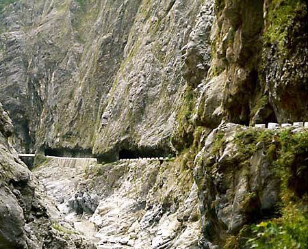
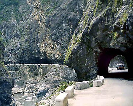
Taroko National
Park in Taiwan
Rick Archer's Note: The pictures below are from
Taroko National Park
in Taiwan. I found them on another web site listed as
"Guoliang". However in March 2010, Ben from California emailed
me to point out they are actually photographs of a tunnel in Taroko.
I regret the mistake.
|
 |
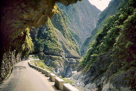
In these pictures, you can
see how the road followed the path of the river flowing through the
valley.
Rick
Archer's Note:
Oops!
When I found the two pictures on the left on the Internet, they were
listed as "Guoliang".
However, a reader named Ben suggested these pictures are not of Guoliang but
rather Taroko. I think the reader is correct, by the way.
Let's add
Taroko to our lists of interesting places on the far side of the
world to check out!
|

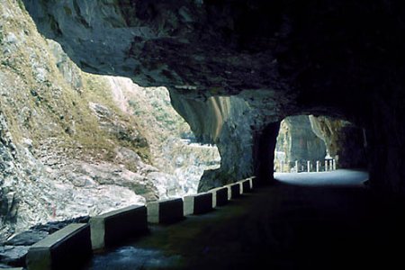
This picture is DEFINITELY from
Taroko National Park
in Taiwan.
it sure looks like the same place
as the two pictures on the left. |
|
|