THE HANGING TUNNELS OF TAIHANG
Kunshan, Xiyagou and Guoliang
(and maybe 3 more!)
Story written by Rick Archer
November 2011
|
Forward
In China about
270 miles southwest of Beijing there exists a series of three tunnels
(possibly even six!) that are cut right out of the
side of the mountain.
Located in
China's rugged Taihang mountain range, what makes these
tunnels remarkable is that all three were hand-carved out of
solid rock. The work was done by untrained farmers who
were desperate to find a
way to connect their remote villages to the civilization
around them.
|
 |
 |
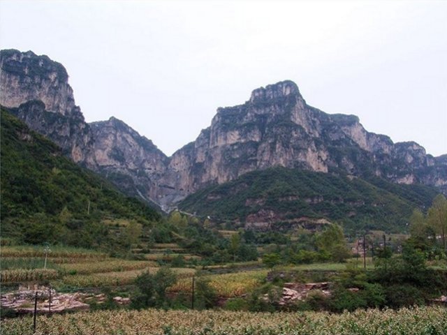
For the most part, the
Taihang mountain range is dotted with little villages nestled in
valleys between the mountains. These villages are usually found right next to
the banks of the streams and rivers that transport their waters to the
Yellow River. The mighty Yellow River, undoubtedly the world's
muddiest river, lies about 50 miles to the south.
In addition to the small
farming communities in the valleys, there are a few villages that
exist high up in the clouds. These villages are built on plateaus
which allow sky-high farming. Back in the old days reaching
the valley below was no easy feat. Individuals could climb
rock ladders up and down, but carrying large crops down to market or
bringing heavy supplies up to the top was nearly impossible.
Even the mule trails were long and difficult.
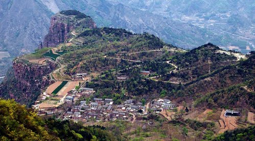
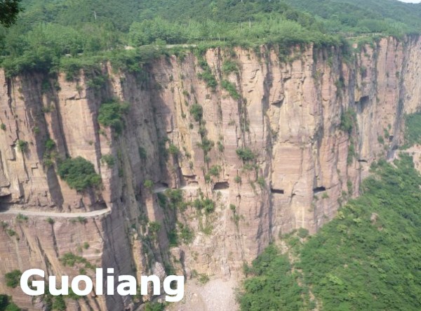
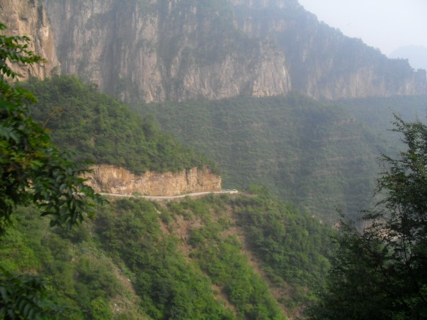
A small village named
Guoliang was probably the first to
carve a road right out of the mountainside. Once their neighbors
saw their success, two nearby villages - Kunshan and Xiyagou - went
out and did the same thing.
|
|
In order to
appreciate this story, it will help to explain a little about
myself first. My name is Rick Archer. I live in
Houston, Texas, USA. For starters, I
have never been to China.
As of 2011, I
became
a semi-retired dance instructor who once owned SSQQ, the
largest social dance studio in America.
During the last
ten years of my 32 year career running the studio, my wife
Marla and I discovered that our dance students loved taking
"dance cruises" around the Western Caribbean.
Marla
got a license as a travel agent and began booking once a
year cruises that would take 100 people on wonderful trips
to Jamaica, Cayman, and Cozumel. Thus
SSQQ Travel
was born.
Marla had many
requests to broaden our horizons, so in 2005 she scheduled a
cruise trip to Alaska. This trip was well-received. We
took 70 people. I had such a good time in
Alaska
that I decided to write a story about the trip for the
people back at home. I got so many compliments on my Alaska
story that I got in the habit of writing recaps about all our trips.
I doubt that my articles are up to the standards of National
Geographic, but at least you can see how I acquired my
enjoyment of writing travel stories.
|
 |
So far I have
written over
20
articles on our cruise trips including stories on
Hawaii, Spain, France, Norway, Greece, Turkey, Egypt, Italy,
Ireland and of course the Caribbean.
My favorite
stories have been about
D-Day
in Normandy, the colossal failures experienced building the
Panama Canal, the wandering river that ruined
Ephesus, the second greatest port in the Roman
Empire, and the true story of the cruise ship to
Egypt
that nearly capsized.
Obviously I have
an interest in travel and I like to write about faraway
places. When you live in Texas, you don't get much
further than China 6,000 miles away.
So what
qualifies me to write stories about three remote tunnels
that I have never seen and know nothing about first-hand?
Not much,
really. I think I got the job primarily because no one else
was particularly interested.
However, I have
done a good job. For example, you will find my story about
the Guoliang Tunnel on the first page of any Google search.
|
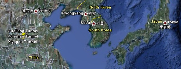
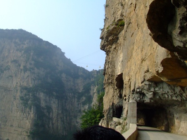
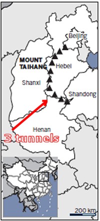
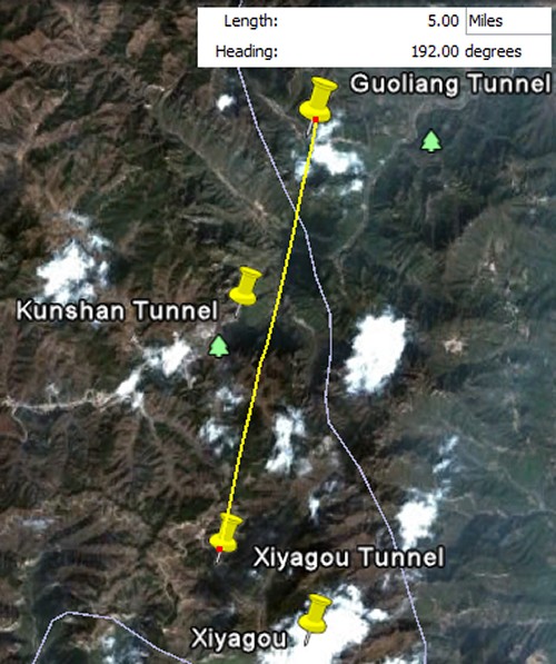
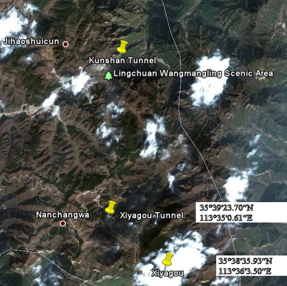
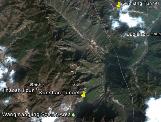
Here is a
picture from Google Earth of our 3 tunnels. They are
only 5 miles apart. Guoliang is in Henan
Province while Kunshan and Xiyagou are in
Shanxi Province.
|
It All Started with
Two Anonymous Emails
My interest in
China began when I received a pair of random emails late in 2006.
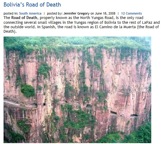
The first email contained contained 23 pictures identified
as a dangerous road in
Bolivia. The
pictures of the Death Road were amazing! As I studied
the email, it figured it had probably been
forwarded around the globe 10,000 times before someone
finally passed it on to me.
About a week
later,
I received a second unusual email. This one contained pictures of a dangerous
mountain climb at a sacred mountain in China known as Mt. Hua, or
Huashan.
To this day,
I have no idea who created those two emails, but the
pictures were incredible. The two emails worked
together to spur my interest in learning more about the
dangerous hiking trail in China and the dangerous cliffside
road in Bolivia.
There was only
one problem. Neither email contained much
information. Now I had to know the
story behind the pictures!
The more I looked
at the pictures, the more confused I got. Some of the
pictures did not look like they belonged together. After visiting the Internet to learn more about
Bolivia's "Road of
Death", I solved the mystery. The "Road of Death" email had
15 authentic pictures of a frightening narrow road running
along the side of a vast cliff, but it also had 8 pictures
of some weird tunnel cut out of a mountainside that did not match the other
15. These were two different places!
Curious, I started to nose around the Internet.
Unfortunately, at that time there was virtually no information about
the place on the Internet. Eventually I got
my answer. The remaining 8 pictures of the tunnel were from some
place in China known as "Guoliangcun".
Who mixed the
Bolivia and China pictures together and "why" will always be
a mystery. In fact, to this day, there is still
confusion. I found a 2011 website that listed this
picture of Guoliang Tunnel as part of the Bolivian Road of
Death. This confusion drove me crazy!!
Nevertheless, I was
still determined
to learn the story behind the pictures. I spent my entire
2006 Christmas vacation
poking my nose around the Internet for information on
the roads in Bolivia, Huashan and Guoliang.
|
 |
|
The
Four Stories
I published what I discovered in January 2007
with articles on Huashan, Guoliang, the deadly road in Bolivia plus
a dirt road in Russia's
Siberia that turns to quagmire whenever it
rains.
My stories were virtually the first
stories in English on all four locations. From that point on, any
Google hit on one location invariably led to people browsing
the other three stories as well.
Every time
someone read
one of my stories, it
registered as a �hit� on Google.
Thanks to the
interest, almost overnight my four
stories rocketed to the Numero
Uno spot on Google for each
location... and
stayed there...
Five years later
all four stories can still be found on Page One of Google for
Huashan, Guoliang, Bolivian Death Road, and Russian Mud
Highway. Type in those key words and look for
yourself.
From that
point on, anytime someone typed �Guoliang�
or
�Huashan�
into Google, they were directed to my web story. By
continuing to list my story first, Google made sure my
articles would be the first thing to capture every random eye
searching for something about these places. In
other words,
because
Google said my stories were popular,
they stayed popular.
The
Huashan article actually became a
phenomenon of sorts. It featured some very scary pictures of
a dangerous mountain climb. There were rumors people
had lost their lives.
Let me amend that. They weren't
rumors.
My
article was the first story written in English
about Huashan.
People around the planet were incredulous
when they read about the amount of danger involved.
They had already seen the pictures, but my story took the
fear to another level. The story quickly became an Internet sensation
and went �viral�.
Meanwhile, thanks to the 2008 Olympic Games
in Beijing, thousands of Westerners were researching China
for places to visit while they were over there.
Strangely
enough, rather than being warned away, people were drawn to
the danger.
Throughout
2008, especially during the summer leading up the Games,
Huashan became a must-see visit for many people
thanks to the hype generated by my article. One Internet
writer had this to say about the phenomenon:
Hua Shan mountain gained
some amount of notoriety years back when an article appeared
on the internet sharing one hiker's harrowing experience.
The article might seem hyperbolic at times but it is
believable for experienced China travelers.
Nevertheless, the
original author has updated the site, saying that a
number of people have reported the safety conditions vastly
improved. I visited the mountain in 2009. Although it is
quite imposing for a tourist hike that sees large numbers of
visitors, careful hikers in good condition needn't worry.
Take a
wild guess
which 'original author' they were referring to.
Meanwhile, Guoliang, the little
village in the sky with the amazing tunnel, experienced the
same
tremendous upsurge in tourism. Due to
its proximity to Beijing, Guoliang received many guests
during the 2008 Olympics just as Huashan did. Like
Huashan, there is a strong possibility my article played a
part in alerting the English-speaking world to its existence.
So why were my stories important? Before 2008, there just wasn't that
much written on the Internet about China IN ENGLISH to begin
with. So when the entire world came looking for places
to visit, Huashan and Guoliang made it into the spotlight
due
to my stories written IN ENGLISH.
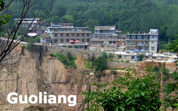
Thanks to the boost during the
Olympics, things at Guoliang would never be the same.
This little bitty place in the middle of nowhere had become
a permanent fixture on China's Travel Map.
When I revisited Guoliang in 2010 via
the Internet, I
noticed three major developments. First of all,
it now had a year-round movie studio. Guoliang had
gone Hollywood. How funny!
Second, the road inside the tunnel was
extremely well-paved. My original pictures showed only
the rough rock surface. Obviously the Chinese
government finally pitched in and helped to upgrade the
infrastructure to handle the increased traffic.
Third, resting at the top of the
mountain were several brand-new hotels. My original
pictures showed no large structures at all.
All of this had
taken place in the past 4 years. Obviously my article helped put
Guoliang on the map... or did it?
In an appalling development, in
October 2009, I received an email from a Korean man who said
that my placement of Guoliang on my website map was about 200 miles
off. I was flabbergasted. So I spent three days
searching via Google Earth to locate the true location of
Guoliang. During my search
for Guoliang, I ran across a mysterious place known
as Xiyagou.
Amazingly,
Xiyagou had a tunnel carved right out of the mountainside
just like Guoliang. For a minute I assumed I had found
Guoliang, but realized this wasn't it. Now I was even more confused!
Not only could I not seem to locate Guoliang, I had managed
to find another tunnel I did not know existed.
When I eventually
located the exact location of Guoliang, I breathed a
huge sigh of relief.
Since I am the
current
keeper of the flame, I felt it was my responsibility to get
it right. I updated my website to
alert
the Western world to the correct location of Guoliang
However, I
was irritated at my
inability to solve the mystery of Xiyagou. My problem was
related to the fact that there was still so little information about China on the
Internet in English. I wasn't aware of it at
the time, but there was plenty of information on Guoliang on
the Internet. Unfortunately, it was all written in Chinese.
A lot of good that did me!
The thing that
you have to understand is that China has only been open
to Western visitors for the past 15 years or so.
Fortunately, as more and more
Westerners visit these places, they turn around and
share information on the Internet using English. I have
benefitted greatly from this development.
Sometimes I read their stories and post links to them.
Still others help by contacting me directly. Lots
of people email me after
their visit to Huashan or Guoliang to give me a heads up. Thanks to them,
I turn around and share their information with the
English-speaking world via my website.
For example,
in November 2010, a man named David Goorney
emailed me with a link to his 6 minute
Guoliang Tunnel
video.
In July 2011, a man named
Luke emailed to provide the
exact directions to
Guoliang in both English and Chinese.
Thanks to David and Luke
and other contributors, slowly but surely my body
of knowledge was not only increasing, it was becoming more
accurate as well. Or 'current' if you prefer.
But there was still one mystery
that bothered me. I had pictures of mountain
tunnels that really did not seem to match my Guoliang
snapshots. For lack of the proper scientific phrase, Guoliang's mountains had an unmistakable
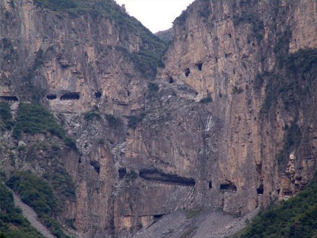
bright red-orange tinge to
them. When I looked at this
picture on the right, I had first assumed that this was Guoliang I was looking
at. But after I discovered Xiyagou, I began to
wonder if this different-colored rock tunnel was a picture of Xiyagou.
Little did I
know that it was neither! This was a picture of yet
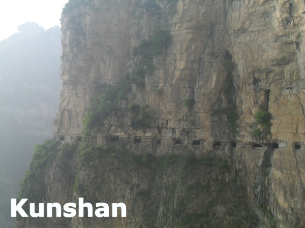
another tunnel location I had never heard of - Kunshan.
|
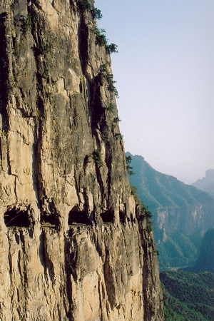
Note: the Xiyagou Tunnel doubles back on
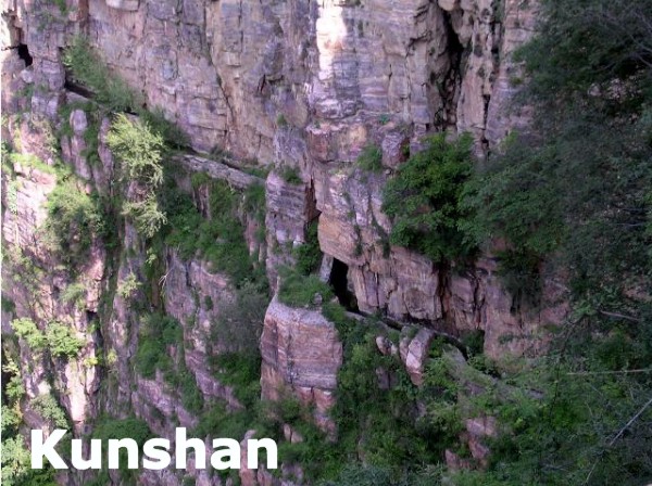
itself while the Kunshan Tunnel has only one row of windows.
Behold
the Modern Guoliang! Now it has hotels atop its cliff.
 |
It
Ain't Easy Flying Blind!
Back
when I started I had no choice but to rely on the
pictures I had seen in the emails. Considering I have never
been to China and considering when I first began writing about Huashan
and Guoliang there was little written about either place in English,
I had no other way to obtain information but to take
what little there was to offer on the Internet.
After a lot of
digging, I pieced together little bits of information from
many different sources to put some great stories together.
Using the pictures and the fragments of information, I made
some educated guesses to make the stories more readable.
|
 |
Guoliang Headaches
Unfortunately, I
made several glaring errors in the process. One of my errors was
telling the entire world that Guoliang was two hundred miles
to the north which put it in a different province.
Let me tell you
something you probably already know - there is a lot of
inaccuracy on the Internet. Back when I started,
Huashan, for example, was placed in Tibet on one website.
Then thanks to an error in one of the original two emails,
Guoliang was listed in Bolivia.
I could tell
Guoliang probably wasn't in Bolivia, but where it really was
required some digging. When I finally tracked Guoliang
down in China, the Internet site placed Guoliang in Hunan
Province, not Henan which is where it really is.
Changing one singe letter created a colossal mistake!!
Here is what I
read in 2006 on the other website (note: these are someone
else's words, not mine).
The mystery
pictures of the Yungas Road in Bolivia were actually
from the
Guoliang Tunnel Road
in Hunan
Province, China."
Consequently, I
myself placed Guoliang in Hunan since I assumed the Internet
site was correct. That is a perfect example of flying
blind.
For the next
couple years, whenever I went to another website, I saw
Guoliang resting happily in Hunan Province. Then came the
Day of Reckoning in 2009. Suhan, a Korean man who had
visited Guoliang, was kind enough to write and point out my
error.
From: Suhan
Sent: Monday, October 12, 2009 1:18 PM
To: dance@ssqq.com
Subject: Regarding the Guoliang Tunnel
Hello Mr. Archer,
I've read your site with great interest as I wanted to
travel to Mt. HuaShan. It's definitely a great mountain,
and after my travels, I can attest that it's not as
dangerous as your main article suggests. But I'm sure
you've already received a lot of correspondence
regarding the mountain.
I'm actually emailing you
about some inconsistencies regarding your article about
Guoliang Tunnel.
I'm a Korean studying
Mandarin in Beijing, and was looking for other sites to
travel to in China. Of course, I wanted to check
out Guoliang tunnel, but wasn't able to find it.
It turns out that the tunnel is actually in
Henan
Province,
which is a different province from
Hunan
(??) as mentioned in your article. Hunan is more famous
for being the province that Mao Zedong was born in.
Also, your map
that shows the location of Guoliangcun is totally wrong
too.
I know this won't be a high priority for you, but
it would be great if you took the time to correct these
inaccuracies when possible. It would
be so kind if you could identify the exact location on a
map.
At first I was
incredulous. How stupid could this man be!?!?
EVERY SINGLE WEBSITE I WENT TO PUT GUOLIANG IN HUNAN!
I found a dozen
websites that agreed with me. What more proof did I
need?
However, just to
be sure, I began to study each website a little more
carefully. Then my face turned pale white. I had just
realized that every single one of these websites had simply
copied my information! They placed Guoliang in
Hunan because I SAID IT WAS IN HUNAN.
You can imagine
my chagrin. How absolutely embarrassing. I was
personally responsible for misleading the entire planet to
the correct location. So much for my sacred role as
the Gatekeeper. Crestfallen, I invested the next three days of my
life combing Google Earth in a desperate
Search for Guoliang.
It's a funny story now, but back then I was appalled.
As long I live,
I will never forget how smug I was thinking about the
stupidity of the Korean man... only to learn who the stupid
one really was.
Fortunately I
doubt my mistake caused much damage or I
would have heard about it. My guess is once someone
got to China, they were directed to the correct location.
But I have no doubt they muttered a few choice words about my
crummy directions along the way.
|
Huashan
Headaches
Huashan was
another story. I got some serious complaints about
misleading information I posted.
|
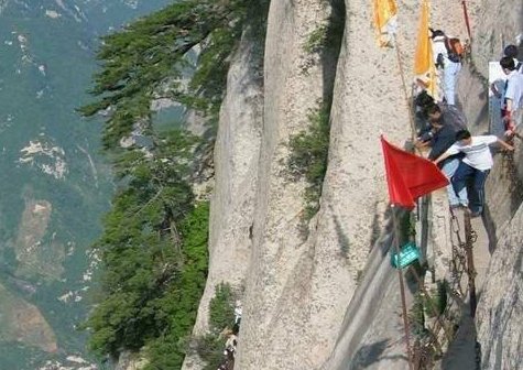 |
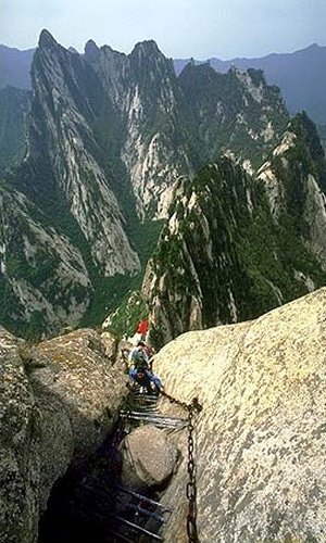
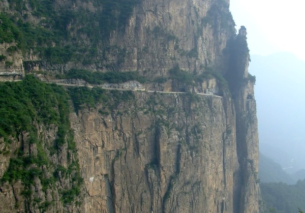
Put yourself in my
shoes. I took one look at the
Huashan pictures like these and concluded this
had to be the most dangerous hiking trail I
had ever seen!
Yes, experienced
mountain climbers could handle this place, but it was billed as a
'hiking trail' open to the public.
Every day hundreds of crazy kids were climbing sheer rock faces
with little or no safety equipment. Most of these climbers
were amateurs. One dumb mistake and they were goners.
Take a look. What
do you think? Do you want your kid climbing this place?
|
So I wrote that the
Huashan hiking trail was the most dangerous hiking trail in the world.
I received a torrent of email. Some of the letters completely
agreed with me. However, many others said I was nuts and cursed me for
scaring potential tourists away from the area.
What I did not know was
about the same time as I first published my scary story in early 2007, the Chinese
authorities had begun a significant upgrade to the safety features
of the trail. As it turned out, yes, the climb had once been
very deadly, but now thanks to the improvements, I was wrong. The trail had been
declawed so to speak. But I didn't know that. I was just
going by the pictures.
|
 |
Meanwhile many Western visitors wrote me back to explain
they didn't think the climb was nearly as dangerous as I had made it out
to be. As I came to understand where the mix-up was, slowly
but surely I changed my tune to reflect that the climb at Huashan
had been greatly improved. The letters indicated you still had to pay attention
during the climb, but
you weren't in nearly as much danger.
People seemed to sense that I was flying blind. Some people scolded me,
but most people cut me some slack. Even better, some of them decided
to come to my rescue and explain what they thought was the mix-up. These benefactors made a huge
difference. Even though they realized some of what I
said was wrong, they still appreciated that I had helped them
discover
about the existence of obscure places like Huashan and Guoliang in the first
place. These people decided to show their gratitude by sharing
what they had learned with me upon their return home. I really
appreciated the tacit teamwork. In this
way, little by little my website descriptions of both Huashan and
Guoliang have become more accurate.
One of the people who
was kind enough to write me was a gentleman named Wei
Han. By chance, he wrote in 2009 shortly after I had
finished my arduous search for the
"lost village of Guoliang". His letter appeared just
one week after I had become frustrated about my discovery of
the mysterious Xiyagou and my utter lack of knowledge about this
area in general.
Wei Han had written me
about Huashan, but I figured it didn't hurt to ask. So, on a whim, I decided to ask
Wei Han if he knew anything about Xiyagou.
As
they say, be careful what you ask for. I got
more than I bargained for!
|
THE
MYSTERY OF XIYAGOU DEEPENS
From: wei han
Sent: Wednesday, October 28, 2009
To: dance@ssqq.com
Subject: about huashan
Hello Rick,
I have seen your website on Huashan
Mountain, which impressed me with its details and
responses attached.
Just to clarify things a little bit, I
went there in the 1990s. I
wouldn't say it's unbelievably dangerous, and it's certainly
not realistic to expect people falling off every minute, but
every step I took in some relatively dangerous
parts of the trail, I
needed to give my full concentration.
I didn't even dare to
turn my head around, the only thing I was looking at is my
feet and the stairs. (and I promise you, if you concentrate,
you will not fall off or anything).
When I went there, there certainly is no safety measures
such as harness, and I heard in recent years, in those steep
90 degree climbs, the locals have built a safer steel stair
next to the original stone stair, so all this adds
to the safety of the trail.
And I certainly think it's unfair for people to go there,
expecting 'mountain climbing' type of danger, with a
touristy outfit.
Also, it's interesting to note the major Huashan accident
that one of the email have mentioned. My father was one of
the 4th military medical school students that have
participated in the so-called 'huashan rescue', he recalled
that on that day, he and his schoolmates stood at the very
edge of the long narrow cliff (canglong ridge, apparent no
supporting chain installed at the time), hand in hand, so
that they themselves have formed a human wall protecting the
other tourists.
My dad said he thought at the time 'uh
oh this is
it!'...lol.
And thank you again for the
informative website, I am very glad it has attracted so much
attentions, because the sheer beauty of the mountain itself
is worthwhile.
Regards, Wei
RICK ARCHER
REPLIES
From:
Rick Archer
To: weihan
Subject: RE: about huashan
Date: Wed, 28 Oct 2009
As I piece together bits of information from people like
yourself, I gather that my original assessment that Huashan
was once a dangerous climb was legitimate. You say that if
people pay attention and concentrate, they will be safe. Yet
at the same time, your very own words - "I didn't even dare
to turn my head around, the only thing I was looking at is
my feet and the stairs" - indicate that you were well aware
that any mistake could be fatal.
It is my guess that as China opens its doors to
ever-increasing tourism, they are modernizing the facilities
of their major attractions. That
includes safety features. I have
heard that recent improvements have taken a great deal of
the danger out of the climb. From my perspective, this is a
good thing.
I don't regret labeling the Huashan climb as dangerous. One,
perhaps my criticism called attention and helped officials
decide to make it safer. Two, my 'danger' story also brought
attention to the beauty of the area as well. With increased
attention came curiosity and new Western visitors as well.
By the way, when your father said, "this is it", what did he
mean? Did he mean 'this is it, this is wonderful' or did he
mean 'this is it, never again'?
Just curious!
Thank you again for your kind words, Wei.
By the way, do you know anything about Guoliang?
Guoliang is another
story I wrote about a location in China.
Have you ever heard
of a place known as Xiyagou?
I am trying to learn
more about both locations, but have exhausted the
Internet material available to Westerners.
Assuming you can read Chinese, perhaps you know
something I don't.
WEI REPLIES
From: wei han
Sent: Wednesday, October 28, 2009 2:35 PM
Subject: about huashan, guoliang, and
xiyagou
Hello Rick,
I have never been to either those locations before
(and they certainly weren't even very famous
even among
chinese
nationals), but just finished checking out a bit
of info on the
chinese internet
Apparently, guoliang tunnel is one of the 3 'hanging tunnels'
located within Taihang mountain range spanning across
several provinces. The 3 tunnels are as follows:
1. guoliang tunnel in henan province near guoliang
village is the most famous tunnel, but
also the shortest
tunnel. The village is now
quite a touristy spot, so you can imagine the original feel
is pretty much lost.
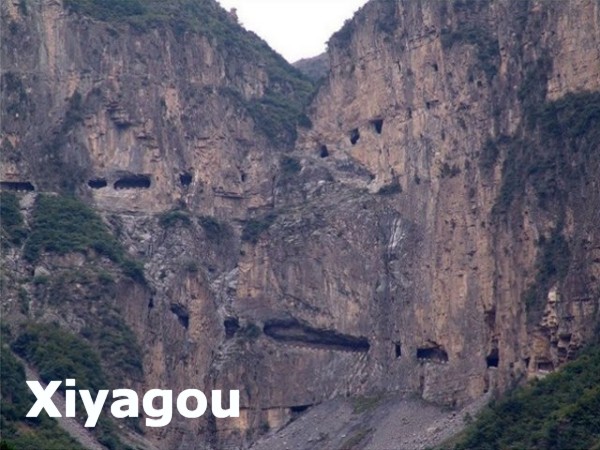
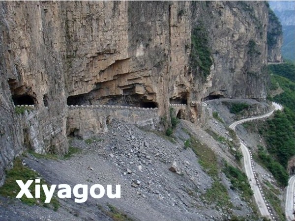
2. xiyagou tunnel in shanxi province.
It is 1.5 km long I
think, and near xiyagou village
which is a little basin 1000m lower than the mountain peaks
surrounding it.
xiyagou is longer than guoliang.
Because xiyagou is located deeper within taihang
mountain, it is much more
remote and less known; it's also
the most dangerous to drive and difficult to build in the
first place. It was built by the locals who were pretty much
geographically trapped within the mountain who desired
outward communication
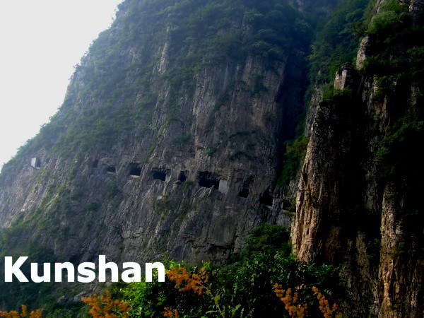
3. kunshan tunnel (again, much longer than guoliang
tunnel.)
All 3 of them are all interlinked. guoliang and xiyagou is around ten km apart.
The tunnels are more known for the impossible achievement in
building them. They were built originally by villagers with the help
of hammer in 30 years and lots of death as you can imagine.
but it is definitely a very difficult drive.
Here is a link (in chinese) with some quite nice pictures
about
Kunshan tunnel, the author went there by car.
If you have any
other thing about the place that you specifically want to
know, please email me and I will try to find out from
Chinese sources.
btw, my dad meant 'my life is going to end here'...^_^
Regards Wei
Rick Archer's Note: As I stared at Wei's reply,
I shook my head. Wei had just identified yet a
third tunnel!
Not only was
there Xiyagou, now I had to learn about Kunshan Tunnel as
well. Good grief.
I could not help
but wonder if there were any more man-made, hand-made
tunnels in that area.
|
|
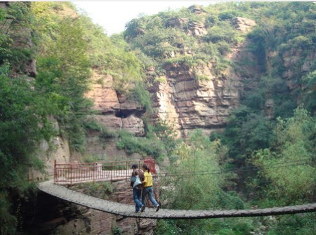
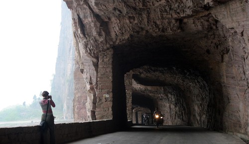
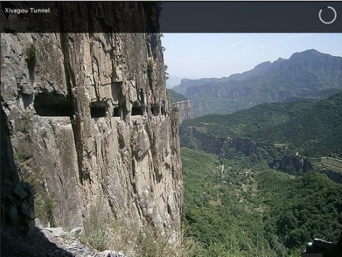
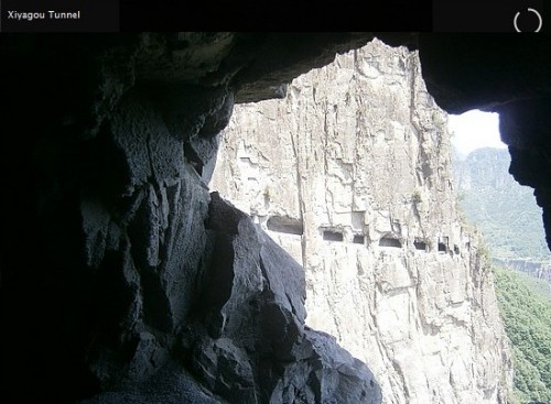
Xiyagou - look
for the "double back" in the distance
Xiyagou close-up of the "double back" feature

The
Kunshan Tunnel has a straight line of windows |
|
The View in 2005
 |
What
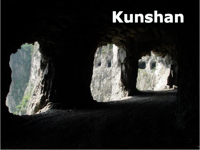
Was Previously Known about Kunshan Tunnel
As Wei Han
pointed out, up to this point the major source of
information about Kunshan came from a
2005 Chinese blog about Kunshan that included some
terrific pictures of the tunnel.
I recently
reviewed this blog from a 2011 perspective. One area
of mystery remains concerning this picture. This is
the top of the tunnel and the top of the mountain. As
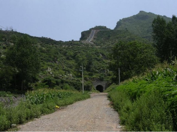
you can see, there is NO IRON GATE blocking the exit.
That hiking trail is part of the Wangmangling Scenic Area.
As of 2011,
there is now an iron gate blocking the tunnel.
Study this 2011 picture. Do you see the ticket booth?
When Paul Evans
visited this tunnel in 2011, the gate was locked. Here
is what Paul said, "The
gate is locked but a bloke opened it to let our driver turn
around. That's how I got the photo of the entrance and the
sign with admission fees etc."
Another picture
from 2005 shows that Kunshan Tunnel was still in use as a
means of transporting farm goods to the other side of the
mountain. Also note that the road was unpaved.
As of 2011, the
tunnel is now completely paved... and there is absolutely no
traffic in the tunnel because it has become a dead end.
That iron gate that stops all traffic at the top.
Look how
attractive the tunnel is today versus the 2005 look.
Today Kunshan Tunnel has become a "ghost tunnel".
It seems very
ironic that there seems to be practically no use for this
magnificent Kunshan Tunnel at all. How strange is
that?
|
| |
|
Paul Evans
Rick Archer's Note:
In September, 2011, I received a very interesting note from an
Australian man named Paul Evans.
As I read his letter, my
eyes grew large. This email was from a man who had been
inspired in part by my website to go visit Guoliang. Then for
the fun of it, he visited none other than Kunshan Tunnel as well.
Even better, he had pictures for me!
Unbelievable. If I
didn't know better, the Universe was trying to help me along.
First I complained I didn't know anything about Xiyagou only to have
Wei Han write me a letter one week later.
Then I complained how
little I knew about
Kunshan Tunnel only to have Paul Evans offer to send pictures and
tell me everything I wanted to know. I could not help but
smile. Thank you!
Yes, I was flying blind
on this project, but thanks to a lot of help from people around the
world, I was finally able to get some very accurate information out
to the English-speaking part of the world. Awesome!
From: paul
evans
Sent: Friday, September 23, 2011 8:49 PM
To: dance@ssqq.com
Subject: guoliang
Rick, after studying your site and others for a year....i finally
got to Guoliang!!! boy was it worth it.....absolutely!!!!
and... in the next valley.....Kunshan tunnel, which is spectacular
beyond words!!! Cannot believe so few people know of it!
I will be putting some photos up on google earth on this road
shortly... truly incredible and worth all the trouble to get there
before it becomes "disney-fied"!!
thank you for igniting a fire that i did not believe could be put
out!!!!
Paul Evans
From: Rick Archer
To: 'paul evans'
Sent: Saturday, September 24, 2011
Subject: RE: guoliang
The western world - including me - knows little about China's
Kunshan Tunnel. You are in a position to publicize it with
pictures and story.
I will help you if you wish. I can create a Kunshan Tunnel page
right next to my Guoliang story and link them. You will be given
full credit in any way you are comfortable with. Once you finish your
story, either post it yourself or send it to me and the pictures.
Whatever you are comfortable with, Paul.
Plus anything you learned about Guoliang would be appreciated.
As it stands, I have some sort of 'mythology' posted on my web site
about the origins of the tunnel. If you have more to add, I would
like that� or debunk my story if it is nonsense.
As you know, I am totally dependent on the input of people who have
actually been to these places.
Rick Archer
From: paul
evans
Sent: Tuesday, September 27, 2011 5:12 AM
To: Rick Archer
Subject: Re: guoliang
thanks for getting back.
setting up a
site is all a bit beyond me!! however....if you are interested, I
can send you a cd of my photos, video and screen shots of google
earth if its of any help (australian internet speeds are very
slow...trying to send 80+mb of data would be frustrating to say the
least). You could use the photos as you wished.
I can also pass on any info i have learned.....i.e. google now has
new imagery, roads show up better because they have all been
concreted in the last few years...compare the road as shown in your
link to tianya.cn to now!!
Guoliang....your site has the best info, I couldn't add anything
except...accommodation is easier...motels galore, but thankfully,
the old part of the village is off to one side and being
preserved....so much more info.....let me know if your interested.
It wouldn't
take long to get a cd off to you. Paul Evans
From:
Rick Archer
To: 'paul evans'
Sent: Tuesday, September 27, 2011 10:54 PM
Subject: RE: guoliang
I will gladly accept your offer, Paul. You will be given full
credit.
The value of your pictures would be to show the world more
photographs of a location that is under-reported in the Western
world.
After I look at the pictures, I will send you a list of questions. I
will put myself in the role of tourist who is thinking of going
there and has a bunch of questions. That should yield some very
valuable information.
Just so you know, I can't remember ever adding "USA" to my address
before! Funny. Rick Archer
From: paul
evans
Sent: Wednesday, September 28, 2011 5:28 AM
To: Rick Archer
Subject: Re: guoliang
Rick, you should try writing your address in chinese characters....that's a
challenge! will work on things and get a cd away to you within
a few days. Paul
|
Kunshan
pictures
contributed
by
Paul
Evans
 |
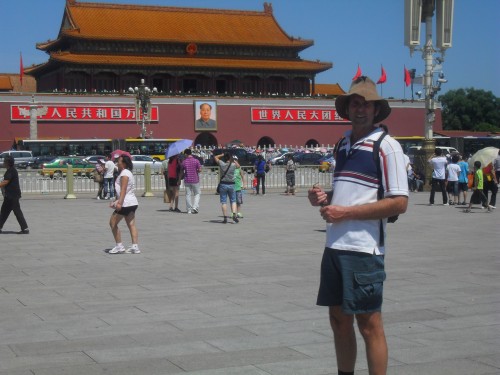 |
After asking a few nosy questions, I learned that Paul Evans lives
in Mudgee, Australia. Mudgee is located about 110
miles west northwest of Sydney in sheep-grazing country near
the Blue Mountains. Paul works as a
plant operator in a quarry.
Paul and his
friend Lyn spent five
weeks in China this past summer 2011. Lyn had been to China
twice before, but this was Paul's first overseas trip.
Paul said Guoliang was the highlight of his trip. In
addition they got to see many rural areas of China as well as the
Tibetan foothills.
Since Paul is
seen pictured here at the famous Tiananmen Square, I guess
we can assume they
probably made it to Beijing as well.
Paul was kind enough to
include a write-up of his visit to Kunshan. I will share his
experiences
with you shortly. In addition to sharing
his photos, Paul also took the time to post a brief video of his tour
through Kunshan tunnel on youtube.
Paul Evans' Kunshan Tunnel Video
|
|
|
|
|
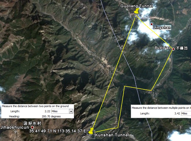
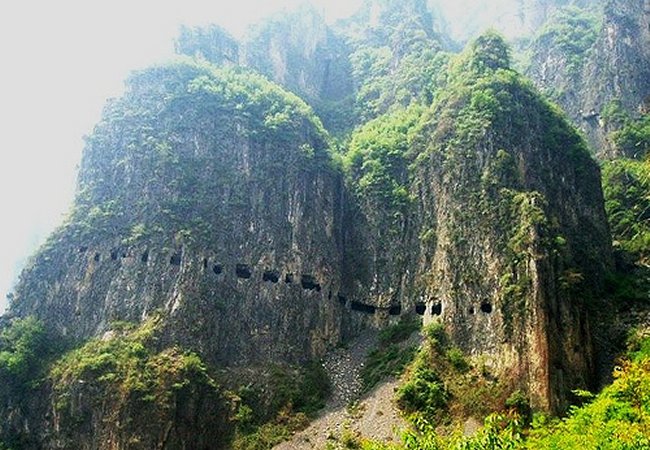
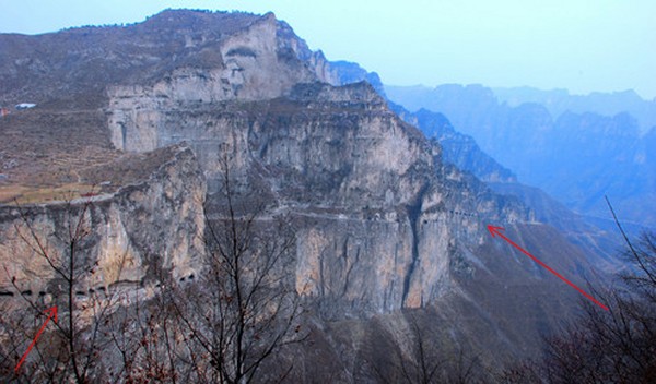
Kunshan Tunnel
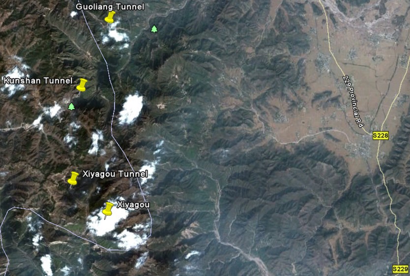
Rick Archer's Note:
As you can see from this
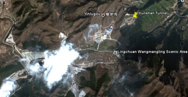
Google Earth map, the Guoliang and Kunshan
tunnels are only about 2 miles apart... assuming you can fly of
course.
The coordinates for Kunshan
Tunnel are:
35�41'48.50"N
113�35'12.75"E
If you want to walk, it doesn't look that bad. Following the zigzag trail through the valleys
appears to add only a mile.
From what I gather, it
takes two hours to cross the distance on foot. Apparently the
Kunshan Tunnel is easily visible for much of the hike, so getting
lost is unlikely.
By the way, Google Earth
is a modern miracle. It connects our entire planet. If you don't
have it, go get
it. It is free!!
If you type
35 41 49.71 N 113 35 14.37 E into
Google Earth,
you will find a Kunshan picture contributed by "Tall Paul".
That's our Paul! And now to Paul's story.
|
 |
| |
|
How
We Found Kunshan Tunnel
Written by Paul Evans
I found Kunshan totally by accident. Although I knew about
Kunshan and its closeness, for some reason it didn't figure in our
original travel equation. I suppose it never registered
because I had no idea what it looked like or where exactly it was.
To be honest, I was just so overwhelmed to see Gouliang that I was
perfectly content.
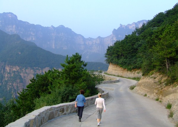
We spent
three days at Guoliang. One day Lyn and I plus our friend
Patty were walking along the southern road from
Guoliang (here is a picture of our exploratory walk). We
headed south past Ling Shan.
About
halfway along, looking south, I was scanning the horizon.
Something far in the distance caught my eye. I saw a series of
little dots on the side of a cliff.
I was
immediately curious. As we continued to walk, I kept staring
at those dots. Was it my imagination or were those little dots
on the side of the cliff windows of some sort?
Then I noticed a cliff road climbing
the gorge several miles up ahead. That road seemed to be
headed towards those windows.
I was stunned. What was I looking at?
Then it dawned on me this must be the Kunshan Tunnel. Wow!
On the spot, that changed the agenda!!!
We backtracked to
Guoliang and arranged for a car to take us to Kunshan village.
I couldn't figure out why, but there seemed to be little information
in Guoliang about Kunshan.
The village is only two miles away with a tunnel to boot, but it
could be in far off Tibet the way people reacted to our questions. It
seems the locals know about the village but are unsure about the cliff
road.
We were dropped off at the village and the way was pointed
out....straight into a corn field....WRONG!!!!
Why Kunshan is such a mystery to Guoliang is one question I could
never figure out. I know everything there is to know about my
home town and the area around it. Why would it be any
different here?
But there was no info at all in Guoliang. It was hard to find
any one who knew anything. Like I said, our driver dropped us
off in the village and pointed us to a corn field. I was
incredulous at this level of ignorance.
We saw a farmer at his house opposite the intersection of
where the cliff road begins. Not surprisingly, he did not
speak a word of English. So I drew a couple pictures.
With the help of drawings and my use of charades, he agreed to take
us there on his tractor for 100 rmb ($15). Anyone wanting to arrange
anything in China should learn to use drawings... they worked
brilliantly!!!
Expecting to be taken to the entrance, we were most surprised when
our farmer friend kept going. We were given the full tour all the
way to the top of the mountain. Here's a picture of Patty
getting off the truck.
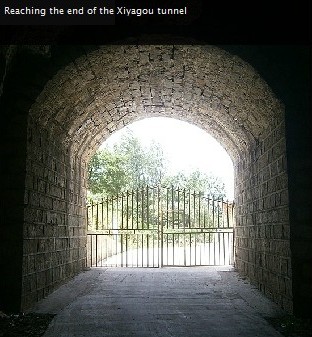
The tunnel is not continuous. The road is about 8 km long and
the tunnel section is about 3 km.
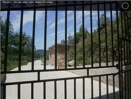
There
is a locked gate at the end of the tunnel which is where the
Wangmangling Scenic Area begins. We would have like to have
stayed, but I didn't want to lose our driver, so we turned back
around.
Our driver took us back. He was kind enough to stop to allow
us to take photos. We couldn't communicate but this guy was
great. I gave him an extra 50 rmb because it was worth every bit. I
wish I had gotten his name but for anyone else trying the same, I
imagine he would be easy to find. As I said, his farm is within 100
metres of the intersection.
When I go back I will give him a framed photo. He would be so proud!
After we finished visiting the tunnel and taking pictures, it took
us under 2 hours to walk back from Kunshan village to
Guoliang...easy walking.
To walk up the road to the tunnel from Kunshan village would be
about the same, but to walk the length of the road would take
several hours as you need to double back. It would be feasible
in a day if you are fit. Count on a 6 hour journey - 2 hours
for the tunnel, 4 hours back and forth. Personally, I would
look for the farmer who took us up, simply because it was so much
fun!!
If you can get a driver to take you from Guoliang to Kunshan, as we
did, then you might have time to see the Wangmangling Scenic Area.
The cable car!!!! I didn't believe it when I saw it. At the top of
the tunnel is a locked steel gate. Past the gate is a ticket
office for the Wangmangling scenic area located on top of the
mountain. Something very dynamic is happening up there, but I
wasn't able to check it out.
From what I gather, the Wangmangling Scenic area is more a part of
the Xiyagou Tunnel 2 miles further to the south. I
regret I didn't have the time to investigate more fully. For
the present, down below Kunshan is a sleepy little farm village but
for how long???
You should try
and get there before it becomes "disney-fied"!!
Kunshan is
truly
incredible and certainly worth all the trouble.
As for the history of the road, I know nothing at all. The one
thing I do know is that road was concreted between 2005 and 2010 as
was all the roads in the surrounding area, including Guoliang.
Due to these paved roads, they reflect light better. This
makes them much more visible on Google Earth!
If you can find Guoliang, you can certainly find Kunshan. The
directions for Guoliang on your
website remains the best. I cannot really add to it, but
getting to Guoliang was a lot easier than expected.
The bus staff etc from Xinxiang onwards all know where the
foreigners are going. They help you along the way as far as
pointing out the right buses etc. You get let off at the
entrance to the scenic area to buy your ticket, then get back on
only to be let out again at the start of the 3 km hike to Guoliang.
By the way, this hike in Guoliang is worth walking if only to heighten the realization of
where you are.
Next time I visit I will definitely keep going and find the Xiyagou
tunnel to complete the trilogy!
|


Little is
currently known "in English" about the
Wangmangling Scenic Area.
Anyone who knows more is welcome to share info!
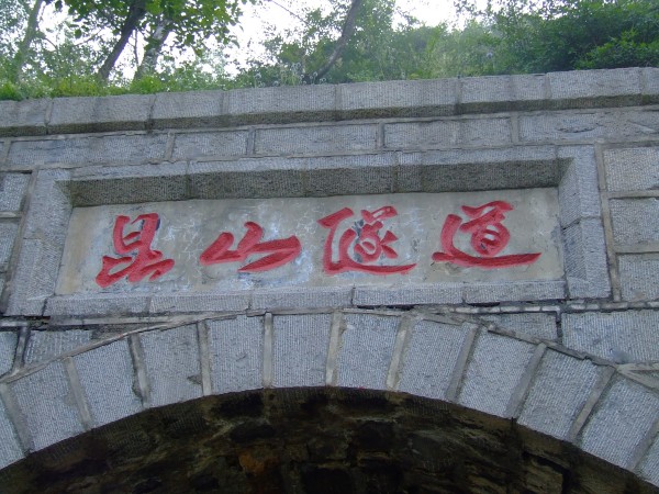
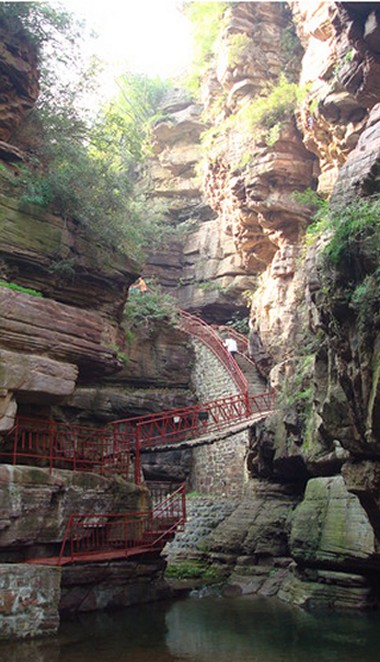
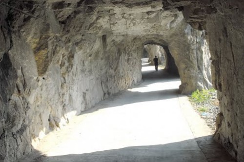
This sign
marks the end of the tunnel. The words say "Kunshan Tunnel". It is the entrance to the
Wangmangling Scenic Area.
|
|
The Stepping
Stones of China's Stairway to
Heaven
By RAYMOND ZHOU
AND
SUN RUISHENG,
China Daily
Forward with
a note from Rick Archer
The brilliant picture is
the tunnel in Guoliang. As we know, the Guoliang Tunnel is
what spurred my original interest.
Thanks to my previous
research plus the contributions from many recent visitors, our 2011
body of knowledge about Guoliang in the Western world is pretty
solid. However, to date there has been practically nothing on the English-speaking
part of the Internet about Xiyagou or Kunshan. Paul Evans has
solved our thirst for knowledge about Kunshan for the time being.
But what about Xiyagou?
When Paul first
contacted me about Kunshan in September 2011, I took a quick peek on
the Internet to see if there was any information I could add about
Xiyagou. Nothing. The place was nearly a complete blank
on the English side of the Internet.
Do you believe in
synchronicity?
By an
amazing coincidence, I ran across three articles about
Xiyagou and the surrounding Taihang mountains that appeared in
the China Daily on November 3, 2011... one week before I
started my own article. And they were all in English!
Nice timing!
A word of note:
The China Daily is an English language daily
newspaper published in the People's Republic of China.
China Daily was established in June 1981 and has the
widest print circulation (over 500,000 per issue, of which a
third is abroad) of any English-language newspaper in the
country.
Published Monday to Saturday, it is regarded as the
English-language "window into China". It is often used as a
guide to official policies. It claims to serve an increasing
number of foreigners in China, as well as Chinese who wish
to improve their English.
|
 |
|
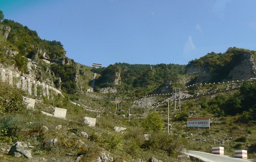
China's Taihang Mountains
 |
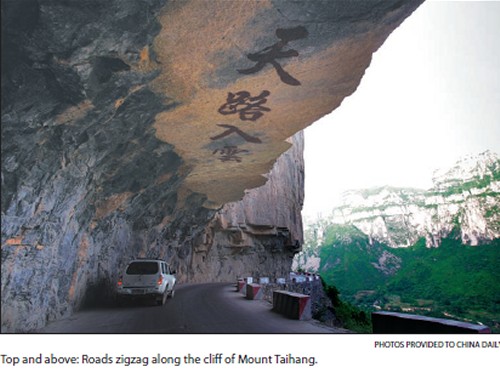
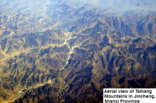
Taihang is a 400-km range
(250 miles) that traverses three
provinces in northern China.
A mountain is usually known for its peak or height.
Not Mount Taihang, or the Taihang Mountains.
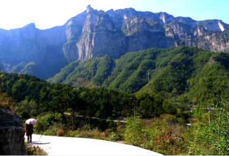
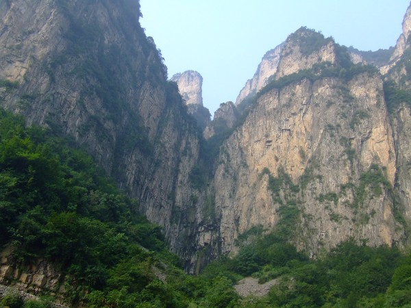
It is known for its many rugged cliffs.
The range's most breathtaking sites are the precipices that
run hundreds of meters, as if nature had cut it like a chef
slashing a piece of tofu.
Nowhere is this topography more evident as in
Wangmangling, which is 1,700 meters at its highest, but
drops off to 300 meters.
It is not only the demarcation between Shanxi and Henan
provinces but also a giant step in the staircase that forms
the Chinese terrain.
China is flat along the east and increasingly mountainous on
the west. Some experts compare the gradual elevation to a
flight of stairs.
The southern part of Mount Taihang
is where the western plateau falls almost perpendicularly to
the North China plains.
|
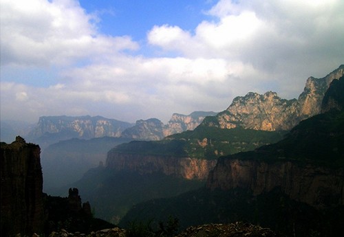
In other places, the fall is eased into
more gradual steps.
The mountain is made up of three principle layers, with the bottom 3
billion to 1.8 billion years old, and the top 600 million to 400
million years old.
However, the bottom layer, which consists of sandy gravel and shale,
are not as resistant to the elements as the quartz sandstone on the
top. Over millennia, the bottom was hollowed out and the top toppled
down, forming these faulting wall-like surfaces.
Taihang is a 400-km range that traverses three provinces in northern
China.
It is the mountain that gives names to Shanxi (literally west of the
mountain) and Shandong (east of the mountain).
According to some theories, its northern tail includes the hilly
western suburb of Beijing.
If you fly out of the capital city to Central or South China on a
clear day, you can almost see some of the steep cliffs from the
right wing of your plane during the first hour.
Taihang is encircled by the mighty Yellow River to the south. The
sharp drop in height has created many spectacular sceneries - and
folk tales.
One of the stories is about Wang Mang (45 BC-AD 23), a rebel general who
attempted to snatch the crown from the Liu family.
He chased Liu Xiu (6 BC-AD 57) all the way to the ravine-filled
southern Taihang. At one point, he
cornered Liu on a cliff.
The desperate Liu jumped and made it across the gorge, which looks
like a couple of meters, but a world away from Wang's clutches. The
rest, as they say, is history: Liu Xiu became the founder of the
Eastern Han Dynasty (AD 25-220), ending two decades of violence and
atrocities and beginning a period of peace and prosperity.
Wangmangling (literally "Wang Mang Ridge"), is - strangely -
named after the pursuer who was eventually defeated - not the
escapee and ultimate victor.
However, you should not take these legends too seriously, as they
are not corroborated by historical research but, rather, just add
color to nature's offerings.
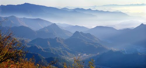
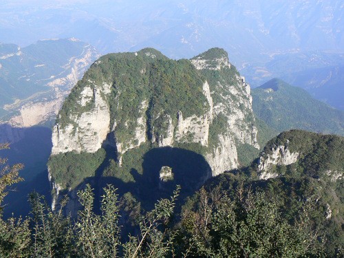
Many of the 56 peaks in the Wangmangling scenic area, which covers
40 sq km, come with legends, some based on resemblances to fairy
goddesses or animals, others constantly shaped by floating clouds
and changing weather.
Hidden atop these peaks
are remote Shangri-las just waiting to be discovered.
The best stories may be the ones you
create with your own imagination.
Cloud mirages and escarpments are nature's gifts for a dramatic
setup.
The plot is for you to carve out.
|
 |
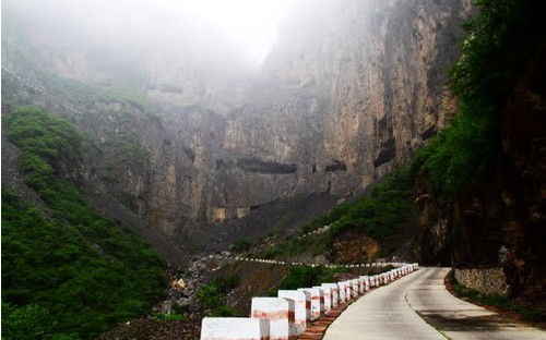
Xiyagou - the Rocky Road of China's Past
By RAYMOND ZHOU
CHINA DAILY
|
Located next to the Wangmangling Scenic Area,
Xiyagou is one of
six �hanging
tapestry-like roads�
in the southern part of Mount Taihang.
Xiyagou sits right
on the border of Shanxi and Henan provinces.
Besides the amazing tunnel of Xiyagou,
there are even more ancient trails across the
mountain range now trodden only by brave souls
in search of the past.
The eight trails that crisscross Mount Taihang were the
equivalents of today�s highways. They were used for regular
transport and postal services.
Their widths drastically change as topography allows.
Some of the places were so narrow that one comes to really
understand the Chinese description �sheep trails�.
|
 |
|
But the precarious spots made sense for defense purposes.
This concept is driven home by a spot on the Flying Fox
Trail, a 20-meter pass flanked by cliffs hundreds of meters
tall that looks somewhat like the setting for the Battle of
Thermopylae in far-off Greece.
The Military Capital Trail runs in part from Badaling to
Juyong Pass � both hot spots for Great Wall climbing today
but important for military protection then.
Most of the defense towers have worn away. The trails are
either taken over by modern roads or left in dereliction.
But a 3-meter stele on the Taihang Trail bears the
inscription, �This is where Confucius turned around and went
home�.Legend has it that a crowd of children stopped
Confucius on his way to the Kingdom of Jin, today�s Shanxi province.
The sage asked for right of way when he saw the children sculpting a
mud castle in the middle of the road.
The children retorted: �Living people give way to castles. How can a
castle yield to a living person?�
Confucius marveled at the precociousness of the Jin people when he
heard this. �The
children here are so intelligent. What do I have to teach
them?�
So he ordered his entourage to return to where they departed.
If you�re into history, behind every ruin and every rock
in the Taihang Mountains is a fable or a story
about how people of yore traveled and lived.
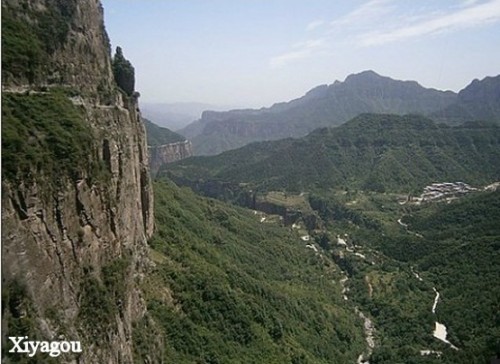
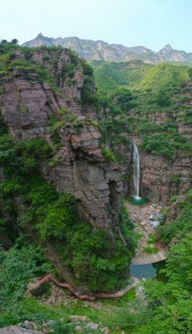
Xiyagou
Imagine a 10.6-sq-km fantasyland of lush
greenery and waterfalls, surrounded by steep cliffs on all four
sides.
It�s isolated from the outside world, free from the turmoil of war
and conflicts. Many poets have
dreamed of such an enclave.
But, in reality, a cocoon of complete self-sustainment has its own
perils. It�s dogged by abject poverty and unspeakable inconvenience.
The ancestors of Xiyagou, on Mount Taihang, ended up here as
refugees.
For hundreds of years, they lived like primitives, learning how to
survive on farming and animal husbandry.
There was no way to move supplies in or out.
To take on a journey to the outside world meant scaling the
heights a la Spiderman.
Fruit, cattle or whatever surplus they could not consume did not
gain any market value. And anything that could not be produced
locally, such as medical supplies, could not be brought in.
Even marriages depended on a barter system. If a household had two
sons and one daughter, one of the sons would have to remain a
bachelor for life.
In 1962, a county official rode a horse to visit the village. The
equine got such a jolt from the precipice �it was scared dead�, the
story goes.
The magistrate, out of pity, allocated 3,000 yuan ($472, but worth
much more at that time) to the village to construct a road.
Thus started the 30-year odyssey for the 7.5-km passage that is
appropriately called �the hanging tapestry of a road�.
The first attempt resulted in a trail that zigzags along the cliff.
Only daredevils would take it. Villagers once tried to drive 27 pigs
to an outside market, and 13 plummeted off the cliff before they had
gone a kilometer.
They chose another route the second time but were halted midway by
impossible logistical difficulties. Wolves, rather than supplies,
started entering the village on this unfinished path.
On the third try, they drilled a hole in a giant rock that turned
out to be so hard that it would not yield gravel.
A technician from the transport bureau said it would take 80 years
to build the road at this speed. The hole was later used as a sheep
shelter.
In 1982, a new design was conceived: This road would spiral across
the surface of a cliff, with windows along the way to remove the
crushed rocks. Every villager pitched in.
What scarce assets they had � including dowries for soon-to-be
newlyweds � they sold to buy tools and dynamite.
A band of young men spent years dangling from ropes to dig into the
rock face. Women provided backup support, including cooking and
sewing.
A tragic twist marred this otherwise uplifting story in 1991, when
the village chief Dong Huaiyue and another man were killed by
explosives while clearing away duds.
The irony is that villagers don�t even
need to use this road today.
There is a much faster multi-lane motorway that goes through another
tunnel and links to the province-level highway network.
Only
tourists, departing from Wangmangling on the north side for the
village, descend on the now-famous Xiyagou Hanging Road.
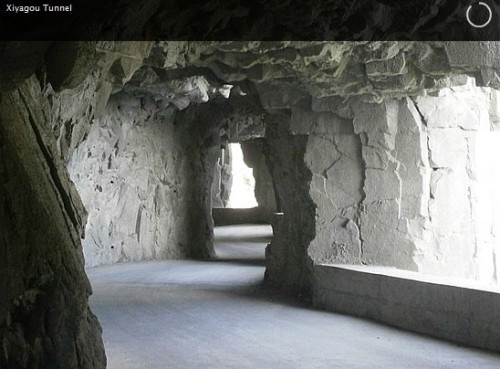
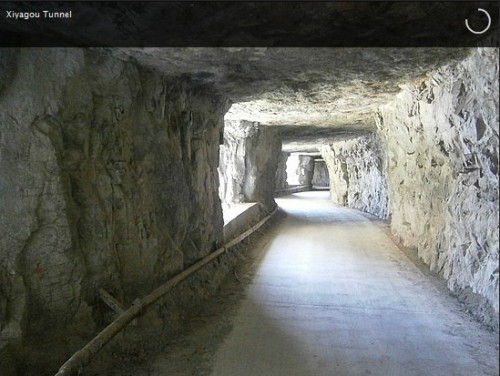
To visit is like walking down a caveman�s
version of a palace corridor. On one side is hard rock, and the other side is a succession of
�windows�, or nothing at all, even a �French window�.
The road�s surface is well paved, but the carving of the
�columns� or �window sills� remains in a rugged state that conveys
the lack of proper tools or sufficient funds for its construction.
Chairman Mao Zedong used to cite the ancient tale of Yugong (Foolish
Old Man), who prodded his whole family to �move the mountain that
blocks the way of their home�.
Today the 200 households in Xiyagou are
considered latter-day Yugongs,
whose tenacity in building the tunnel has now become a legend.
Busloads of tourists crawl down the tapestry-like road to gawk at
the natural wonders and sample the fresh produce.
Villagers no longer worry about fruit rotting in their orchards.
People pay good money for the fruit, which has visibly lifted villagers
from sustenance to a decent living standard.
Could it be a coincidence that the Yugong saga is said to have
originated from this area? Was the
dangerous work of the Xiyagou people nothing more than sheer folly?
Or was it part of the
Cosmic Plan to place a divine reward lying in
wait down the road ahead?
|
 |
|
|
Where is
Xiyagou Tunnel Located?
I decided the correct location for Xiyagou Tunnel
is here:
35�39'23.70"N
113�35'0.61"E
I might add I asked my
Australian friend Paul Evans to double-check for me. He agreed
that this was the correct location. In particular, I used the
picture below to make my decision.
You can find this picture at:
35�39'23.51"N
113�34'42.91"E
|
 |
|
|
|
|
|
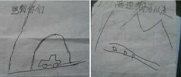
The Mysteries of the Taihang
Mountains
|
|
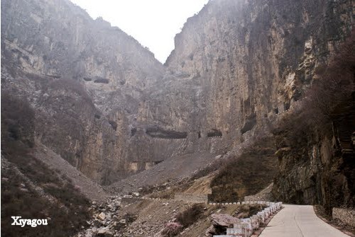
The Three Missing
Tunnels
Rick Archer's Note:
Surely you
noted my highlight in the China Daily article about Xiyagou that
suggested there
are six "hanging tunnels" in the Taihang
Mountain range.
Good grief. I just finished solving the
mystery of Kunshan and Xiyagou only to find there are three more out
there! too funny.
I learned a
new trick doing the research for this article. I discovered
that I could use Google to translate Chinese script into English.
Without this trick, I don't know how I could have been nearly as
confident about what I was seeing.
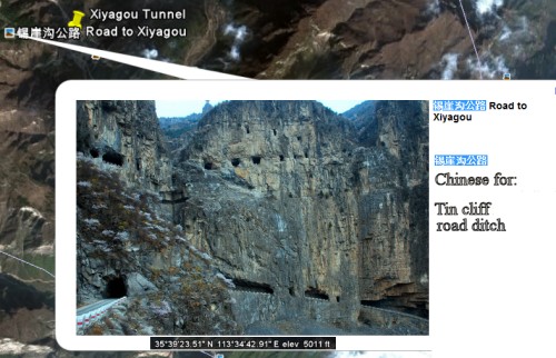
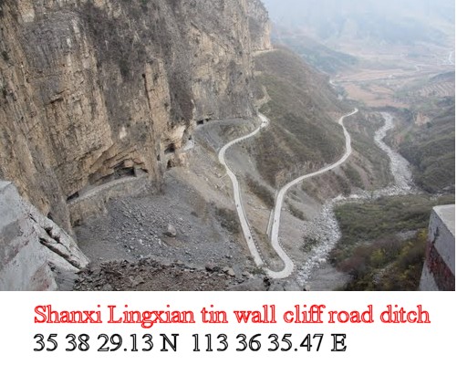
I found this winding road picture on the left just a
few hundred yards from the spot I identified as "Xiyagou" at
35 38 29.13 N
113 36 35.47 E
(plug those coordinates into Google Earth and you discover this
picture for yourself)
When I
translated the Chinese script accompanying the picture into the
Chinese to English Google
Translator, it said, "Shanxi Lingxian tin wall cliff road
ditch". Hmm. That doesn't sound like "Xiyagou" to me.
Fortunately,
I found another picture nearby. (35 39 23.51 N
113 34 42.91 E)
This picture said in English: Road to Xiyagou. Aha! Then I translated the
accompanying Chinese. It also said "Tin cliff road ditch".
I will assume
these "Tin Cliff Road" pictures are in fact Xiyagou Tunnel, but you never know, I could be wrong.
We all know I am far from infallible.
As I have
written, I completely
messed up Guoliang's location a couple years back by about 200
miles. Consequently, I will never
say anything about China with certainty again.
At least you
know how I arrived at my conclusion. Google Earth is so much
fun!
Okay, I found
Kunshan and Xiyagou for you. Now I challenge the readers to
come up with the identity and location of the three other missing
tunnels! I wish you luck.
|
| |
|
 |
Guess What?
I'm not the only person who gets confused!!
Here is a particularly
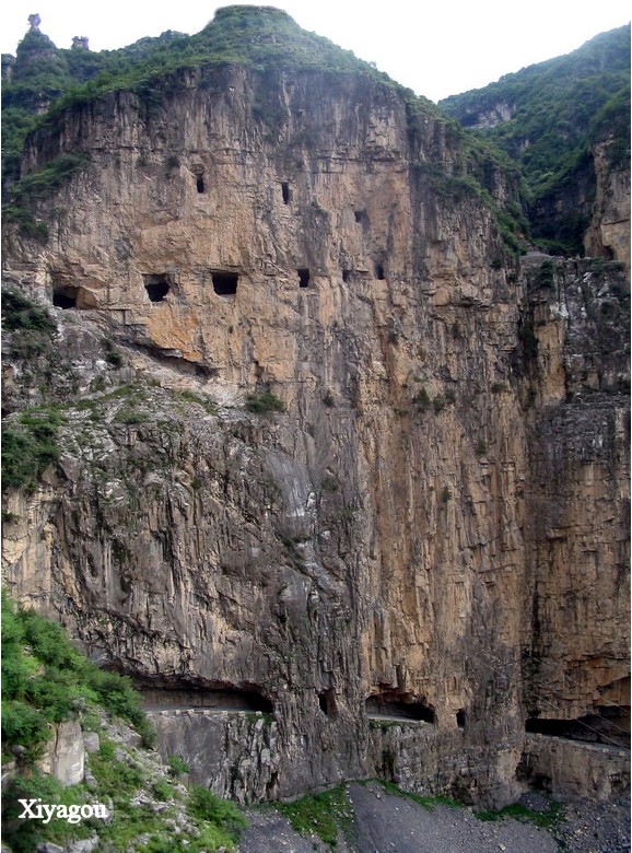
wonderful picture of Xiyagou.
I am no expert, but what
from I gather you can visit the Internet in any language... German,
Italian, French... and yes, Chinese.
In my opinion, what
separates Chinese from these other languages is that German,
Italian, and French at least use the same alphabet as English so I
can make out an occasional word. Not Chinese!!
This is taken from a
Chinese blog on Kunshan (great
pictures!)
在这石下休息,遮住了阳光又感受到石头传来的清凉,山风徐徐,特别舒服,
坐下了就不太想起来,逍遥得让人又再次随意唱起五音不全的歌;太爽快了,
忍不住想仰头打了一个大哈欠。正要打哈欠,一仰头,才发现头上有个大蜂
窝,这下连哈欠都忘记吐气就呆在那了,回过神来,慢慢的,慢慢的起身,
然后头也不回的往前逃跑;怪不得觉得那附近蜂特别多,原来就在老巢就在
我头上,吓人!
So what does it
say? Well, brace yourself.
On this stone to
rest, covered the sunshine and feeling the stones from the
cool, shanfeng slowly, particularly comfortable, Sit down
and not very much to think of it, happy let people randomly
again sing incomplete song iambic pentameter; too readily,
Tempting to face unward a big yawn. Yawn, a face unward, it
was found on the head with a big bee Nest, forget even yawn
breathes out stay under it, back to God, slowly, slowly get
up, Escape and then head back ahead; no wonder that a near
bee is particularly high, and it has in the nest in The top
of my head, scary!
And what is my
point? They say that Orientals are inscrutable.
I don't know about that, but I will say that Chinese
translations are pretty close to incomprehensible. I
get confused all the time and I am sure I am not the only
Westerner to make the same complaint.
|
|
 |
During my Internet
search for pictures of Xiyagou, I found a treasure
trove of valuable pictures. These are wonderful pictures!
As a read his
story, I learned that Nalddo, a young man from France named,
had embarked on an incredible odyssey that spanned 29
countries.
I cannot tell
you how impressed I was by his story. Here are some of his
pictures.
|
 |
|
 |
 |
Rick's Note: There's only one problem. I
think every one of these pictures was actually taken at
Kunshan Tunnel, not Xiyagou.
Remember the rule: The
Kunshan windows go in a straight line while the
Xiyagou windows double-back. Nalddo's tunnel pictures
show only a straight line of windows.
Let's read what Nalddo's blog said (I added the underlines)
|
�The next morning, and a 2-hour bus ride later, we were
at the entrance of Guoliangcun scenic area, in Henan, a
province overlooked by most of foreign tourists. During
the 3 days we stayed in Guoliang, we met only 2
foreigners, and there were leaving in China.
The whole area was a great resting places, with many
Chinese coming here to capture the scenery on paper and
canvas
However, the tunnel itself was quite disappointing. It
might have been very impressive after it was built, in
the 1970s, but since then, it has probably been upgraded
in order for the tourists to drive safely into it. But
cars are so few that I could walked twice into it
without meeting a single vehicle. One of the most
dangerous venues in the world had indeed become one of
the safest!
Even though, I was not disappointed by the detour. I
really liked the place and had a very nice surprise.
As we were walking toward Guoliang, we took a wrong turn
and I spotted some windows into the cliff on the
other side of the valley.
I thought it was Guoliang tunnel, but a local pointed
the other direction. So, the next day,
I wanted to find out what was
it. I backtracked my steps and walked for 2 hours
before I came to the door of another tunnel, much longer
and much more impressive
than the Guoliang tunnel.
It took me half an hour
to walk it, passing amazing scenery in the other valley,
and at the end I bumped into an
iron fence.
I had crossed the mountain and was now in Shanxi, the
adjacent province. I reluctantly walked back when I
spotted a cable car at the
top of the mountain.
There was definitely a very Chinese scenic area (read an
entertainment park) on the other side of
the valley, but for some reasons this tunnel, probably
the highlight of the visit, was closed.
By coming the other side, I could enter, but apparently it was
not known, because I did not meet anybody else here.
After reflection, I believed there might be a fight
between the provincial governments about the benefice of
the tunnel: it is in Henan but who charge entrance fees
in Shanxi government. So, where the money goes to ?
I wanted to show Charlotte what I
had discovered, so we agreed to stay a day more, and the
next day we walked back together to the tunnel. I don't
like to do things twice, but this time I did not regret
it.
The sun was shining, making great photo opportunities!�
As
you can see, Nalddo's interesting story is practically identical to what Paul
Evans wrote. I had fun noting the similarities.
Both men found Kunshan the same way: by accident.
Nalddo visited Guoliang and stumbled upon Kunshan as he
explored the outlying countryside just like Paul did.
He was fascinated when he spotted the tunnel in the distance and went to
check it out.
Both men mentioned the gate at the end of the tunnel.
Both men talked about the cable cars which were part of the Wangmangling Scenic
Park.
I
think I know how Nalddo managed to get the name of the
tunnel wrong.
When Nalddo visited Kunshan Tunnel, he did it on the spur of
the moment. That meant there was no guide or
English-speaking person around to tell him the correct name
in English. Plus he probably could not read the
Chinese signs.
|
|
|
|
I imagine Nalddo left
China not actually knowing the correct name.
Perhaps when he posted his
pictures, Nalddo went to Google
Earth to see if he could figure it out.
He likely spotted the same pictures of
Xiyagou on Google Earth that I did and
guessed this was the tunnel he had visited.
Since everything is
labeled in the confusing Chinese script,
Nalddo probably saw the picture that said
"Road to Xiyagou" in English and assumed
that was the same tunnel as the one he had
visited.
I am sure he never
suspected there was a third tunnel.
Considering how many
times I have been tricked while researching
China, trust me, I am not about to cast the
first stone. I am just grateful to
discover I'm not the only one who gets
confused!
|
An Embarrassing
Footnote
About two days later
after I wrote how Nalddo had gotten the tunnels wrong, something was
bothering me. I got to thinking about it. Didn't Paul
Evans once point out that I had some Kunshan pictures misidentified
as "Xiyagou" on my Guoliang website?
I had a bad feeling about this. I took a peek. Sure
enough, Paul was right. Look what I had posted on another part
of my website.
|
 |
In these pictures, you can see a different
"look" of the tunnel.
Rick Archer 2009 Note:
I think there is a good
possibility these two pictures
are not from Guoliang.
Neither picture resembles the
red rock of Guoliang.
These are more likely pictures of a similar road tunnel
in the village of Xiyagou
about six miles away.
|
 |
|
Here we go again.
Nalddo undoubtedly misidentified his tunnel because he looked on my
website, the so-called "world authority on Guoliang", and compared
his pictures to mine.
I posted two pictures of
Kunshan, called them "Xiyagou"
and the poor man trusted me. My apologies to Nalddo!!
Although I quickly
corrected my mistake, my inaccurate depiction of Kunshan as
"Xiyagou" was out there for the past two years. I guess that
puts me back in the Internet Dunce Corner yet again... and now I
don't have Nalddo for company any more. I'm there all by
myself!
I will say it again.
It ain't easy flying blind!!
|
|
|
|
| |
|
Another
Mystery
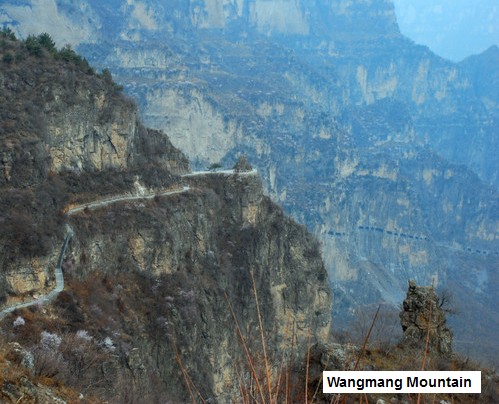
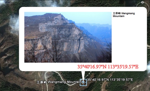
Here is an interesting
picture. As you can read, it is a picture of Wangmang
Mountain.
If you have Google Earth, you can find
the picture here:
35�40'16.97"N 113�35'19.57"E
The picture placement is
located a half mile north of Xiyagou Tunnel and and a mile and a
half south of Kunshan Tunnel.
In other words, this
picture is
almost equidistant between the two tunnels.
Now look at a blowup of
the same picture. There are tunnels on both sides of the
picture! Pretty interesting picture.
So what are we looking
at? Is this Kunshan? Is this Xiyagou?
Or is it both tunnels?
Or is it just one long tunnel!?!?
The single file row of
windows fits the profile of Kunshan. That said, after looking
at how long it is, I cannot even begin to conceive of the amount of
work involved.
I asked Paul Evans.
He said he would wager $100 it is Kunshan. He reminded me that
the Kunshan Tunnel ends at the Wangmangling Scenic area.
I took the picture on
the right and enlarged it to compare to a picture taken from the
Wangmangling website.
It looks to me like the
picture on the left stops about the place where the picture on the
right begins, except there seems to be a brief overlap.
I think the two areas
inside the yellow lines are the same place. This plateau has
to be part of the Wangmangling Scenic area.
|
|

|
Wangmangling
Scenic Park
Wangmangling Scenic area
is an elevated valley in the skies. I am no geologist,
but this valley is probably an ancient cone of a volcano.
The pictures of this valley remind me of the cone of
Diamondhead, the famous extinct volcano next to Honolulu in
Hawaii.
There is
currently very little information on the "English" side of the Internet,
so I
invite readers to share more.
From what I
gather, the Wangmangling Scenic Park is not far at all from
Guoliang. Your only problem will be the giant mountain in
your way. I can't be sure, but I think Kunshan Tunnel
is actually cut into Mt. Wangmang... maybe someone can
confirm this for me.
It would be nice
if visitors to Guoliang could use the Kunshan Tunnel to
reach the Wangmangling Scenic area, but that iron gate at
the end of the tunnel continues to be a real puzzle.
|
 |
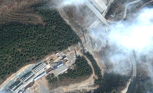 |
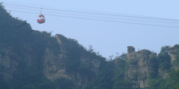
For now, this is what I know
- something is happening. There is a cable car in the
valley set to take tourists to the top. In the mountain
ridges above the valley, there are hiking trails everywhere.
Once you get to the top, you can climb along Wangmang Mountain
and be able to see unimaginable vistas in every direction.
Paul Evans has
this to say:
Looking further west
on Google Earth under some cloud is the
enormous main parking area for
Wangmangling... they must be
expecting a lot of visitors... and
100 yds
south you can see the piers of the elevated
expressway under construction...........the Chinese
tourist behemoth is moving in!!!!!
|
|
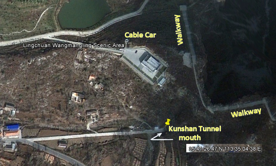
Paul Evans was able to locate the exact
spot where the Kunshan Tunnel meets the Wangmangling Scenic
area.
The coordinates are:
35�41'26.47"N 113�35'04.38"E
Again, the dead end
nature of this spot is a bit baffling. How are people
from the east supposed to easily access this area otherwise?
Why not put that tunnel to use?
Perhaps that tunnel is
open. Below is the itinerary of a biking tour through this
area. As you can see, the bike ride intends to make
full use of Kunshan Tunnel.
|
 |
Day 4
Guoliang village -
Visit the Wanxian Mountain Scenic Area. Visit the Redcliff
Canyon, Lingshan Village, the Sky Ladder, etc.
Day 5
Depart from Guoliang Village to
Wangmang Mountain ---- Xiyagou Canyon---- Huilong
Village
Biking along the Taihang Canyon from Guoliang village to
Huilong. On the way, you will bike through the Kunshan
cliffside tunnel which is much longer than Guoliang
tunnel, you will also visit the Wangmang
Mountain and then bike through the
Xiyagou Canyon.
|
|
 |
In the picture
on the left and right, you can see what appear to be poles
to support the cable car.
Presently this
park is most easily reached from the west.
You can reach it
from the south using the Xiyagou Tunnel.
However, how you
get to this place from the east is unclear.
|
 |
 |
 |
|
| |
|
 |
What do you think about
this waterfall!! The accompanying caption reads "Panorama
Falls mill
Jianfeng".
I found this waterfall
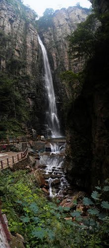
picture 1 1/2 miles due east of Kunshan Tunnel near Nanping. It is 2 1/2
miles south of Guoliang Tunnel.
Nearby I found a
second
waterfall known as the "Black Dragon Pool". It is
nearby as well.
That's all I know. As
usual, the English-speaking side of the Internet supplied little
information.
The point I am getting
at is that there is all sorts of stunning scenery in this area.
I found pictures of nearby hiking trails along cliff ridges that offered
breath-taking panoramas. This area is a tourist's dream if you
like to hike in the mountains.
|
Xiyagou Tunnel, Kunshan
Tunnel, Guoliang Tunnel, the Wangmangling Scenic area, and
waterfalls galore all within just miles of each other. Wow!!
There are hints and suggestions that the Chinese government
is taking serious steps to turn this entire area into a tourist
mecca. In fact, it may have already happened. Usually
whatever I write is at least a year outdated the moment I print it.
So again I
invite readers to contribute whatever they know about what is going
in this fascinating area.
|
 |
|
A Good Idea or
a Big Waste of Time?
Now that we
know more about the tunnels at Kunshan and Xiyagou, we find that
both tunnels have out-lived their practical use. Today they
exist purely as tourist attractions.
I am guessing
that the tunnel in Guoliang was the first to be completed in this
area. It
was built in the early part of the Seventies. According to the
China Daily article, Xiyagou first tried to build a tunnel in
1962, but quickly gave up all hope.
Then perhaps
emboldened by the success of the Guoliang Tunnel five miles away,
the people of Xiyagou
tried again in 1982. The China Daily article mentioned a
terrible accident in 1991. So obviously the Xiyagou Tunnel was
not completed until sometime in the early Nineties.
What bothers
me is that the Xiyagou and the Kunshan Tunnels have both outlived
their original usefulness. They quickly became obsolete.
The Xiyagou Tunnel
probably got no more than 10 to 15 years of value at the most.
The China
Daily article pointed out that the tunnels may not have been the
most practical creations in the world. All that work for 15
years of use. Hmm.
The article
compared the Xiyagou tunnelers to Yugongs... Foolish Old Men.
The article quoted Chairman Mao who remembered the legend of a 90
year old man who got disgusted at the constant chore of walking
around huge mountains in his path.
The
Foolish Old Man of the North Mountain, nearly ninety years of
age, lived behind these mountains. He was unhappy about the fact
that the mountains blocked his way to the south and he had to
walk round them whenever he went out or came back. So he called
the whole family together to talk about the matter. "What would
you say," he said to them, "if I suggest that all of us work
hard to level the two mountains, so as to open a clear way to places
south of Yu Prefecture and the Han River?"
His children were excited, but his wife had her doubts. "With your
feeble strength," she said,
"you could hardly remove a small hill like Kuifu. What
makes you think you can move the Taihang and Wangwu Mountains?Besides, where could
you deposit all the earth and rocks so they would not block
another person's path?"
Mao used this
story to describe the pointlessness of moving mountains.
I suppose the French who failed at the first attempt to
build the Panama Canal back in 1880 would have agreed with Mao...
they spent ten years trying to level a large hill to create the
canal. When they finally gave up, they had lost millions of
dollars, 22,000 men had died from malaria and yellow fever, and only
10% of the project was completed
(Panama
Canal Story).
Conclusion?
Man isn't very good at moving mountains.
Today both
Kunshan and Xiyagou both appear to empty into the Wangmangling Scenic Area.
They may have no commercial use at all, but at the same time, these tunnels have brought all kinds of tourist activity to
their area.
This has all happened practically overnight.
Today Xiyagou
and Kunshan enjoy a much higher standard of living thanks to the
existence of their tunnels. Folly? Maybe. But
fascinating nonetheless.
As I said, I
was unable to access much in the way of information about the
various locations, but the pictures on Google Earth suggest this
area is a tourist's paradise if you like mountain scenery.
Plus there are hints in the articles I read that Guoliang is not the
only place to prosper. This entire area seems to attract
busloads of tourists.
I am guessing
this entire area is fast becoming the Chinese equivalent of our Rocky Mountain National Park
here in the USA.
I suppose as
times goes by, we will learn more. Thanks again to Paul Evans
for helping us gain further insight into this remarkable part of the
world. We are all in debt to him for sharing his pictures and
his knowledge.
Thanks to
people like Paul, we are fortunate to be given a porthole into
mysterious and stunning vistas of China that were previously unknown
to the Western world.
Rick Archer
November 2011
PS - If you
have information to share or comments and questions, please contact
me by email, dance@ssqq.com
|
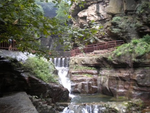
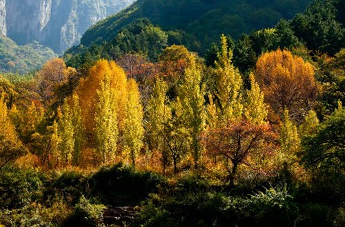

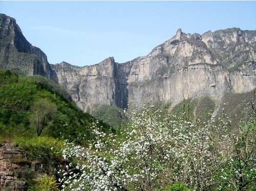
This picture
solves the mystery.
Kunshan Tunnel is unbelievably long! |
|
|