Road to Hana
Home Up Road to Hana


The Road to Hana

Written by Rick Archer
February 2014

Have you ever seen a crazier pathway?  The Road to Hana is a wonderful twisting, winding swervy-curvy road that runs snake-like along the shoreline of Maui Island.

Drivers are treated to incredible vistas.  Look one way and you will see the ocean and beautiful beaches. Look the other way and see lush tropical rainforests and waterfalls galore.  What an amazing treat!

The Hana Highway is a 68-mile stretch of winding road which connects Kahului (red star left) with the little town of Hana (red star right) in east Maui. 

After Hana, the Hana Highway continues to Kipahulu, home of Wailua Falls, Waimoku Falls, Makahiku Falls and the 7 Sacred Pools.  Thanks to these stunning sights, most people are content to stop there and turn back.

Some, however, do continue. After Kipahulu comes Kalepa Bridge (red star at bottom). This bridge marks the unofficial spot where the Road to Hana ends and Piilani Highway, Route 31, begins along the deserted south side of the island.

Although Hana is only 52 miles (84 km) from Kahului, it takes about 2 1/2 hours to drive when no stops are made. Average speed is said to be about 20 miles per hour.  However, typically it is only the locals who are in any kind of hurry. 

The narrow highway is full of twists and turns.  The term "Winding Road" is a vast understatement.  There are 620 curves along Route 360 from Kahului to Hana, virtually all of this road twisting its way through lush, tropical rainforest.

Another feature are the tricky one-way bridges. Out of the 59 bridges, 46 are only one lane wide.     (source: Wikipedia)

Lahaina

Our cruise ship docked in Lahaina on the northwestern side of Maui on Tuesday, 01 October 2013.  The day was something of a marathon.  We were tendered ashore at 9 am. 

The boat ride took 20 minutes and then it was another 40 minutes to wait for the shuttle to pick us up and get us to the car rental in nearby Kanapali 5 miles away. 

We left Kanapali at 10 am and returned to Lahaina at 9 pm.

Our 11-hour round trip covered about 130 miles.  If you do the math, that averages out to 12 miles an hour.  I am sure the trip can be done faster than that, but what would be the point?  The whole idea is to stop and explore along the way... which is what Marla and I did. 

I found a tour guide that said the trip would last "between 10-12 hours with 5 hours of stops along the way"

That sounds like a pretty good description of our own trip.

You may have noticed that the Road to Hana seems to circle something.

That 'something' would be Mount Haleakala, a monster volcano that dominates the entire island of Maui.

Maui is a "volcanic doublet" which means it is formed from two shield volcanoes that overlap one another to form a narrow isthmus between them.

I wrote a story about Haleakala on our 2007 cruise to Hawaii.  The amazing vastness of the Haleakala Crater must be seen to be appreciated.  It truly feels like one has landed on the Moon.

Take note how the North and East side of Haleakala is green and how the south side is brown and barren.  I will discuss that in a moment.
Unlike some volcanic craters, there is no lake atop because the crater has two openings: the Ko'olau Gap and the Kaupo Gap (nearest).


Haleakala (holly-awk-ala) means "house of the rising sun".
The sheer immensity of this colossal volcano is humbling. 

From the distance, the dormant volcano has a gentle, gradual slope that crests at an elevation of 10,000 feet. 

The last recorded eruption took place in 1790, but the geologists say there is no guarantee Haleakala might not roar back to life someday.  Fortunately, this is highly unlikely. Haleakala has drifted pretty far from the notorious "hot spot" that gives life to all the Hawaiian volcanoes.

All the Hawaiian islands owe their existence to this Hot Spot.
The Hot Spot is an opening in the ocean floor that shoots lava to the surface, thereby creating new islands.  Every two million years or so, the new island drifts so far away from the hot spot that it ceases to grow.  At this point, a new island is formed. 

If you have never heard of the "Hot Spot Theory", you should read my article from our previous 2007 cruise to Hawaii.  I find this geological explanation to be utterly fascinating. 
 

Windward Haleakala

The Road to Hana is spectacular for many reasons, but most of all for its beaches, waterfalls and lush vegetation. 

As it turns out, this famous stretch of highway owes its beauty to an unusual wet weather situation created by Haleakala.  The volcano turns out to be an unbelievable rainmaker.

It is very difficult to get a good picture of Haleakala because it always seems to be shrouded in clouds.  Transitory clouds and mists frequently move across the landscape, first hiding and then revealing the mountain's features from below. 

The windward (green) side of Haleakala is home to Hana and everything else on the Road to Hana. This area is remains ridiculously wet year-round due to Haleakala's tall slopes. Trade winds are responsible for blowing in moist air from the ocean, which Haleakala captures and deflects up its slopes.

Once the saturated air cools with altitude, it rains.

The Windward side of Haleakala has rain over 3/4ths of the year. When you drive the Road to Hana, you'll most likely get wet at one point or another.  Fortunately, the rains come and go. If you are patient, the sun will be back out soon enough.

Haleakala creates a "rain shadow" as the moisture-laden trade winds blow across it in a westerly direction coming from the northeast.  As these trade winds are blocked by the north side of the giant mountain, their clouds are trapped on the northern "windward" side of the mountain.  (see picture).

The majority of Hana's weather is highly predictable as it is created by a localized daily cycle of the sun heating ocean, clouds and winds forming as the day progresses, and the winds blowing these clouds into the mountain, where they are forced upward until they hit the inversion layer.

The clouds stack up against this wall (usually between 4,000-7,000 ft) as the day progresses.  You can watch as the cloud cover gradually expands more and more toward the lower elevation areas.  Most rain for these lower elevations (almost exclusively where people live on the windward side of Maui) conveniently comes in the afternoon and overnight.

Waterfall Heaven

In some places, the amount of rainfall on the windward side has been measured at 400 inches per year.  Since my hometown is Houston, Texas, I decided to compare.  Houston gets 50 inches a year.  The Road to Hana gets 8 times that amount! 

We know how much the constant rainfall benefits the vegetation.  However, there is a marvelous side benefit.  There is no such thing as "lakes" in Hawaii.  All rainwater heads straight to the ocean.  Amidst the incredible unending tableau of tropical rainforest, the rainwater rushing to the Pacific creates an incredible array of breath-taking waterfalls.  Practically every two or three miles a driver can stop and either see a waterfall from the road or take a short walk inland to see one.   

The Brown Side

For every winner there has to be a loser.  Although Mount Haleakala is incredibly green on one side, it is dark brown on the other side.  

The south side of the mountain barely gets any water at all.  While the lush, green northeastern part of the mountain receives about 150-400 inches of rain per year, the opposite side may receive only 20.  This dramatic difference explains the green side - brown side effect of Haleakala. 

Not all water hits the side of the mountain.  Some of the clouds get trapped up at the the top.  Atop the mountain there is an enormous hole on the north side known as the Ko'olau Gap

The clouds enter the crater above through this gap.  Once the clouds enter the crater, they cannot escape, so they drop their rain into the crater; the crater acts as a "bowl" capturing the rain.  The water then runs through a wide second gap known as Kaupo Gap on other side of the crater. The size of this gap is testament to the incredible power of the erosion which not only formed the Haleakala crater, but the wide Kaupo Gap as well.

It took me a while to figure this out, but every Hawaiian island has the same situation... green on the northeast side, brown on the south side.  For example, as famous as Honolulu is, the city isn't particularly green.  That is because it is situated on the brown side of an impressive mountain range.
 

The End of the Road

Although the stated name of the game is to visit the town of Hana, there really isn't any impressive about this remote little hamlet.  The real payoff comes about 9 miles further down the road in a nature reserve known as Kipahulu

Kipahulu is where many amazing waterfalls can be viewed.  The guide books say it takes between 30-50 minutes of driving past Hana to reach this area.  And why are there so many waterfalls?  Kipahulu on the southeastern corner of Maui is pounded daily by immense quantities of rain.  Consequently there are all kinds of water vistas that delight the visitors. 

Kipahulu is home to the 400 foot Waimoku waterfall, Wailua Falls, Makahiku Falls and the 7 Sacred Pools, the freshwater swimming pools at Ohe'o Gulch, the Seven Sacred Pools and many wildly popular hiking trails. 

Shortly after the Seven Sacred Pools comes one final landmark, the gravesite of Charles Lindbergh.  Lindbergh was the famous aviator who became the first man to ever fly across the Atlantic Ocean in 1927.  He later became a longtime resident in the area.  Lindbergh was buried in 1974 at the seaside under a large pile of river stones behind a local church. 

The guide books suggest that Lindbergh's Grave should be the last stop for two reasons.  First, there is nothing of interest to see beyond it.  Second, the back road is forbidden to tourists.

Note how the clouds get trapped and linger on the side of the mountain.  By mid-day, these clouds are ready to give the mountainside its daily ration of water. 

As the water drains to the sea below, a vast array of waterfalls are turned "on" to delight visitors to the area every day of the year.

The clouds come in through the Ko'olau Gap, get trapped, and drop their rain into the crater. The rainwater drains thru the Kaupo Gap.

If you look at all the Hawaiian islands, every single one of them is green on the northside and brown on the south.

Gravesite of American hero Charles Lindbergh, the first man to cross the Atlantic by plane in 1927.   At right are the Seven Sacred Pools.

The bountiful waterfalls and the Seven Sacred Pools in the Kipahulu region are considered the true end of the Road to Hana. 


The Forbidden Road!!


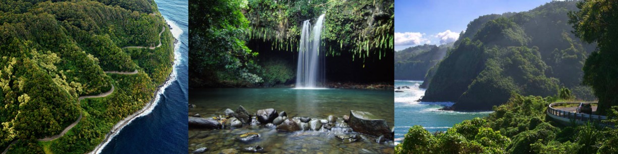
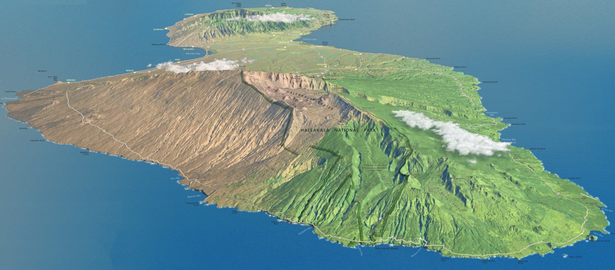
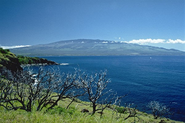
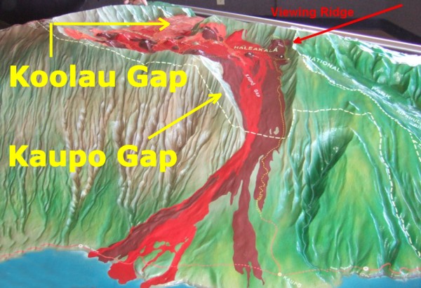
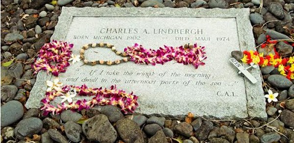
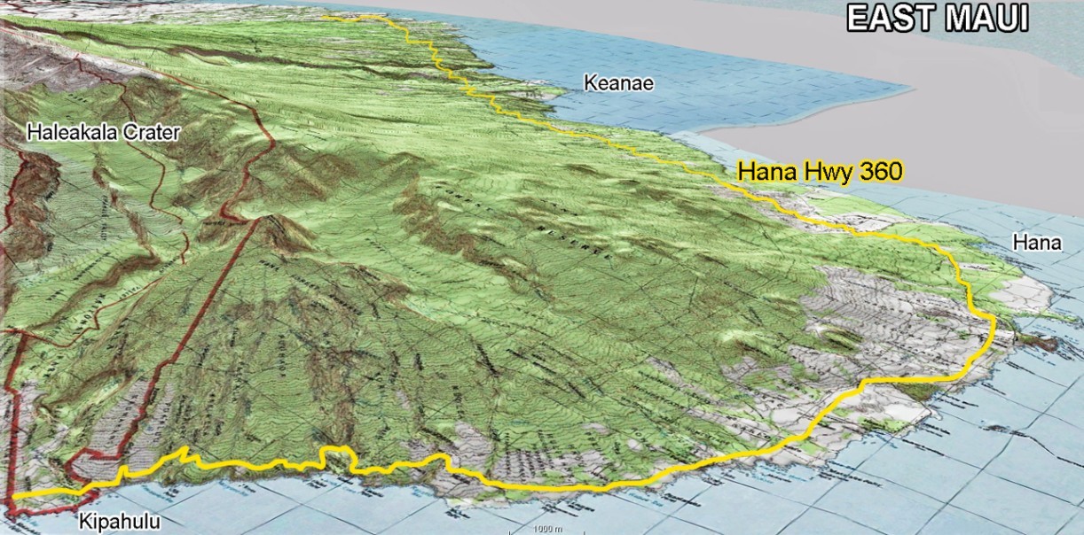
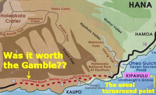
Kipahulu is considered the true end to the Road to Hana.  After Kipahulu, the highlight show is over.

Once you pass Kipahulu and Lindbergh's Grave, you enter the Maui version of "No Man's Land".   Thanks to a combination of poorly paved roads up ahead plus nothing of interest to see, the guide books say that after Kipahulu, 99% of all visitors turn around and head back. 

1% remain curious and keep on driving.  What will they find?

Not much.  After "Lindbergh's Grave", the scenery quickly begins to give out.  On the back side of the mountain, no water to speak of ever visits the area.  The rain refuses to visit since the ridge at Kipahulu seems to capture all the clouds. 
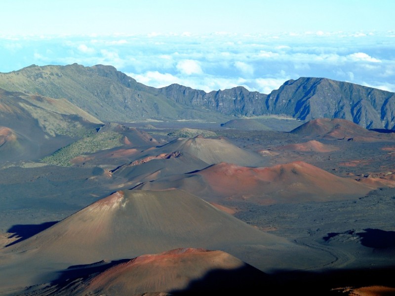
Consequently the landscape turns barren and treeless for the next 30 miles on the back of the volcano.  Over time, the water-starved back side of Mount Haleakala has become a desolate wasteland.  There are thick fields of lava rock everywhere, little soil for cultivation and only the sparsest of vegetation. 
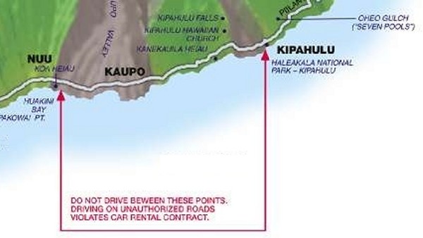
Over the centuries, even the native Hawaiians seem to have ignored the backside of the mountain. The area is said to be mostly deserted with practically no human habitation other than hermits and a few fishermen.  Except for a little fishing village in Kaupo, there seem to be no other real towns. 

Nor is there much a road.  Since there is little economic benefit to the area - no farm country, nothing for tourists to look at - the Hawaiian government has not bothered to invest in a decent road.  This mean a driver cannot make the round trip unless he is willing to take his chances driving on a rocky, rutted unpaved road.  Due to the terrible condition of the road, the rental companies absolutely forbid driving back here. 

Consequently the only people who visit Kaupo village are hikers who drive all-terrain jeeps.  Therefore the Kaupo Gap has been give the title as the absolute Dead End or Drop Dead point on the maps.  "Turn back here or suffer the consequences!"

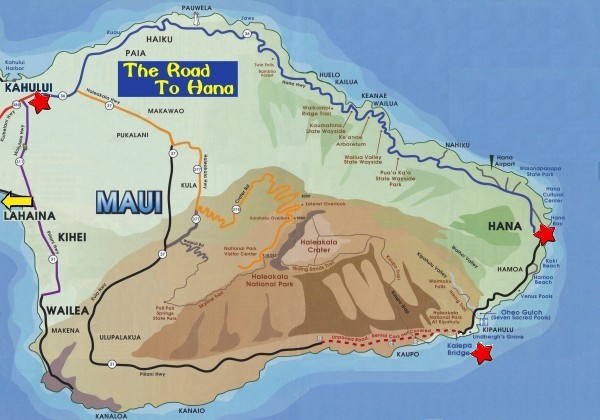
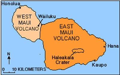
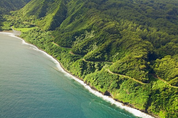
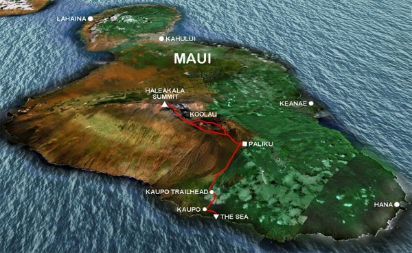
2007: The Big Gamble

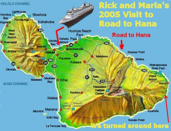
Marla and I first visited the Road to Hana during our Hawaii 2007 cruise.  However, we had no idea how slow the going was. 

They said it took 2 1/2 hours to reach Hana.  Marla and I noted we had six hours to drive. Our agreement was to drive for three hours and turn around.  All the tour guide books said three hours should be sufficient, but not for us.  We had wasted too much time stopping to look at some of the many pretty views along the way.  Now thanks to an early ship departure time, by the afternoon we were seriously pressed for time. 

Due to our curiosity and the constant delays created by an intense amount of traffic that day, our pace had been glacial at best.  Now after three hours of driving, we had just passed Hana.  We were nowhere near the 
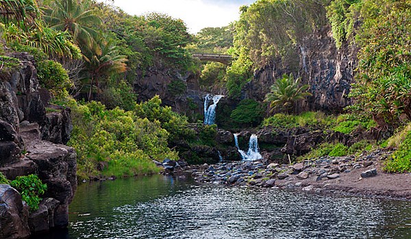
famous Seven Sacred Pools that had been our true goal.  Now what should we do? 

Back in 2007, like every visitor to this area, I wanted to see it all. I was intoxicated by the legendary beauty of the Seven Sacred Pools that just a few more miles up ahead.

However, to visit with so little cushion of time would be a terrible risk.  
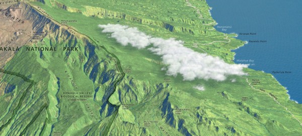
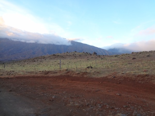
Staring at the map, I looked for a short cut back home.  I had heard a rumor that the back side wasn't nearly as bad as the maps said it was.  Consequently I could barely contain my curiosity about the back side of the mountain. 

There was a part of me that was sorely tempted to simply keep going because surely the back side could not possibly be as slow-moving as the over-crowded Road to Hana.

I was also well aware that driving the back road would be a tremendous gamble.  Obviously there was a road that completely encircled the volcano, but the guide books warned that this back road was in very poor condition.

The map I was using clearly indicated the road on the rugged southern side of Maui was unpaved.  

Not only did I have a map that warned me not to take this road, I had a guide book that warned me not to take it as well.  The guide book suggested no one in their right mind would be foolish enough to continue past Kipahulu and Lindbergh's grave.

What kind of idiot would keep going?  Hmm, well, I was seriously considering it!  What does that say about me?

I didn't trust the guide book.  I thought it was lying to me.

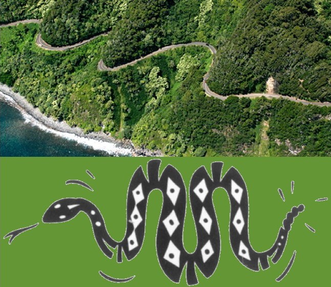
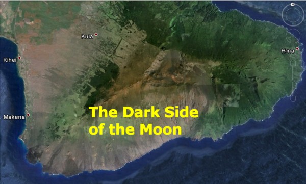
Before the trip I had read one web site that indicated this "Forbidden Route" was Maui's best kept secret. The web site had hinted that the road was in much better condition than the car rental map or the guide book said it was.  The web site referred to the back as the Dark Side of the Moon

The web site made it clear that the people of Maui are so sick of tourists that they warn people away so they have this "secret passage" all to themselves.  

The web site insisted this Forbidden Route across the Dark Side of the Moon offered a much-swifter return to the center of the Island for three reasons - no traffic, no one-way bridges, and a shorter distance. 

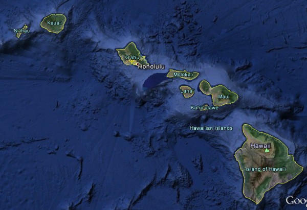
Shorter distance?  Well, not actually. A more accurate description would be "equi-distant". The Kipahulu area was exactly 180° from Kahulu where our ship was docked.

However, given an equal distance, there could be no doubt that substituting a deserted road for the heavily-traveled Road to Hana absolutely guaranteed a swifter path home.  And since we were at the half-way point as it was, the temptation to roll the dice was overwhelming.  Not only would we see it all, we would get home at least half an hour earlier. 

I thought back to what the web site had said.  It claimed the locals preferred to reserve the route for themselves. Why tell the crazy day-trippers like us and force the locals to face traffic everywhere?  Therefore all literature handed out to the tourists was meant to scare people just like me away.

I simply could not get that "Secret Passage" rumor out of my mind.  The temptation to try it was overwhelming.  The thought that the Forbidden Road offered a much-swifter return to the center of the Island drove me up a wall with desire.

Did I have the guts to take the biggest gamble of my life and drive us into the Dark Side of the Moon?

If it was just me, I probably would have done it. However, at the time, a cooler head prevailed... my wife.  Marla calmly reminded me of the consequences of failure. 

We knew for a certainty if we turned around now and nothing went wrong, we had enough time to get back to the ship.
We didn't have cell phone service on the island. 
We did not know the condition of the road.
There would be no traffic on the road to rescue us.
There would be no homes we could go to for help.
If we went too far and the road proved impassable, it would be too late to turn around and get back in time.
If we risked continuing and got stuck, our situation would be catastrophic.  It would mean we would miss the ship.
If we missed the ship for a stupid ass reason like me believing some dumb web site, this would likely result in the complete dissolution of our marriage.
Or murder.  Depending on how badly I screwed up, she might just kill me. She would push me down a ravine when I wasn't looking.  Marla pointed out it would be years before some lonely hiker found my body down in one of those rarely-visited ravines.

Hmm.  Those arguments got my attention, particularly the last two arguments.  So I turned around. 

But the memory of the temptation still smoldered in my consciousness...

Every tourist renting a car is given a stern lecture:  Do NOT drive on the backside of Maui.  You will be in deep trouble if anything goes wrong.

The area beyond Kipahulu is said to be a 30 mile stretch of barren rock, wasteland and rain-starved desert.   This region is so desolate that some people refer it to as THE DARK SIDE OF THE MOON

Rick's Note:  I cannot even begin to explain how badly I wanted to try the Forbidden Road in 2007.  An old joke suggests there are two kinds of vehicles that can go anywhere - ATVs and rental cars.  hahaha.  Apparently the rental company has heard that joke too.

Note the strange green and brown effect when seen from the air. 
If you notice the other side of the island near Lahaina, the other volcano has the same effect. 

The leeward sides of both these mountainous regions are blocked from the rain and get very little precipitation.

In 2007, I chickened out.  Six years later, I would face this decision again.  What would I do in 2013?  

Would I have the guts to dare drive to the Dark Side of the Moon?


Click Here for Part Two:  Road to Hana 2013

   
SSQQ Front Page Parties/Calendar Jokes
SSQQ Information Schedule of Classes Writeups
SSQQ Archive Newsletter History of SSQQ