|
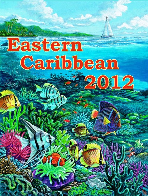
Eastern
Caribbean
2012 Itinerary |
| Saturday,
March 10 |
Depart San Juan, Puerto Rico
|
| Sunday,
March 11 |
Tortola,
British VI |
| Monday,
March 12 |
Philipsburg,
St. Maartin |
| Tuesday,
March 13 |
Basseterre,
St. Kitts |
| Wednesday,
March 14 |
Roseau,
Dominica |
| Thursday,
March 15 |
Bridgetown,
Barbados |
| Friday,
March 16 |
day
at sea |
| Saturday,
March
17 |
return to San
Juan, Puerto Rico |
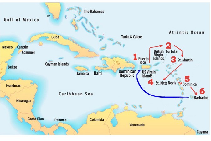
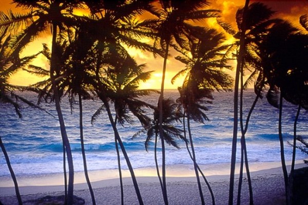
The 22nd SSQQ Cruise
will take place over Spring Break
in March 2012. This cruise will be
very similar to last year's Virgin Island 2011 cruise except
that we will visit 5 completely new islands. This trip
will include the
spectacular rugged and undeveloped island of Dominica with
its 9 volcanoes, including the Boiling Lake in the Valley of
Desolation.
Like last year, we will
travel again on the beautiful RCCL Serenade of the Seas.
This ship features a lovely Atrium dance
floor as well as a Ballroom Dance floor on another deck.
This part of the Caribbean is as an
island-hopping paradise. There is an entire chain of tropical islands stretching from
Puerto Rico all the way down to the northern shores of
Venezuela in South
America.
|
 |
Most Americans know very little about this
region of the world.
There are the Leeward Islands and
the Windward Islands, the West Indies and the Virgin
Islands, as well as the Greater Antilles, the Lesser
Antilles, and the Grenadines. It will be fun to
discover more about this part of the world as we visit 6 of the most popular
Caribbean islands.
Once you review the pictures, you
will see the Virgin Islands and the West Indies are
unusually similar in makeup to the Hawaiian Islands. That is
no surprise since volcanoes helped create these islands.
The Virgin Islands trip is special
for
two important reasons. Unlike our
Western Caribbean trips which visit
just 3 places, this particular
trip hits six different beautiful islands in six days! This
trip is a sightseer's dream voyage, especially if you are a
fan of tropical islands.
There are 7,000
islands in the Caribbean.
The
Eastern Caribbean is an island-hopping paradise.
Not all of these
7,000 islands are inhabited.
Anyone with a decent sailboat can
usually find a
deserted key somewhere for a trip ashore if you want to get
away from the world. Given the balmy weather, sleeping the
night under the stars on your boat isn't such a bad idea
either. Anyone searching for a little personal freedom
would definitely find this an attractive location.
|
Although you do have to factor in
plane fare to Puerto Rico, the
price of the cruise fare is actually priced less than our
Western Caribbean trips out of Galveston.
As most of you
know, we visited the Eastern Caribbean last May 2011.
So in a sense there is a 'same time next year' feel to this
trip. What is different is that we are hitting 5
completely different islands, including Rick's favorite,
Dominica, a rugged, almost totally undeveloped island with 9
volcanoes, seven of which are due to erupt any day now.
Best of all, our
trip takes place over Spring Break! Finally we have a
cruise scheduled at a time the teachers and educational
people can join us.
|
Pricing |
|
Inside
Cabin, Category N |
$637 |
|
Oceanview
Cabin, Category H |
$807 |
|
Balcony
Cabin, Category E1 |
$1007 |
|
Prices
are per person, double occupancy |
|
 |
|
Last
Year's Trip
So where did we go on the 2011 trip?
Like this year's cruise, our trip originated in San Juan, the capital of
Puerto Rico. You are going to really like San Juan. This
was a fascinating city indeed. During our cruise, we visited St. Thomas, St. Croix, Antigua, St. Lucia and Grenada.
You are almost certain
to be interested in what happened on last year's trip, so click
May 2011 Trip and visit
last year's trip.
|
|
|
|
 |
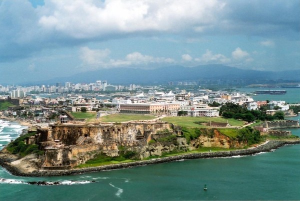
1 San Juan, Puerto Rico
|
|
Puerto Rico is one of the largest islands in the Eastern Caribbean.
Puerto Rico's landscape encompasses mountains, underground caves,
coral reefs, white-sand beaches and an incredibly massive rain
forest that supplies fresh water to most of the island. At the same
time San Juan, the capital of the commonwealth, is a big city with a
bustling business district, glitzy resorts and casinos, as well as
one of the most stunning examples of colonial life in the Western
world.
San Juan is known as "La Ciudad Amurallada" (the walled city). San
Juan was founded in 1521. In 1508 Juan Ponce de Le�n founded the
original settlement, Caparra, now known as Pueblo Viejo, behind the
almost land-locked harbor just to the west of the present
metropolitan area.
A year later, the settlement was abandoned and moved to the site of
what is now called Old San Juan. San Juan is one of the biggest and
best natural harbors in the Caribbean and is the second oldest
European-founded city in the Americas
San Juan is a major port and tourist resort of the West Indies and
is the oldest city under the U.S flag. The metropolitan area known
as San Juan has 3 distinct areas: Old San Juan, the Beach & Resort
area, and other outlying communities, the most important: R�o
Piedras, Hato Rey, Puerta de Tierra, and Santurce.
Many believe San Juan is a small Spanish colonial town with but a
few bustling avenues. However this impression does not aptly
describe the breath and depth of this fine old-world city.
Modern-day San Juan encompasses a vast metropolis that covers seven
unique and distinct districts. This makes for an eclectic
combination of sights and sounds that is essential to the wonder and
joy of visiting San Juan.
Old San Juan/Puerta de Tierra
This is a 465-year-old neighborhood originally conceived as a
military stronghold. Its 7-square-block area has evolved into a
charming residential and commercial district. The streets here are
paved with cobbles of adoquine, a blue stone cast from furnace slag;
they were brought over a ballast on Spanish ships and time and
moisture have lent them their characteristic color. The city
includes more than 400 carefully restored 16th- and 17th-century
Spanish colonial buildings. The Old San Juan attracts many tourists,
who also enjoy the gambling casinos, fine beaches, and tropical
climate. More tourists visit San Juan each year than any other spot
in the Caribbean. A leisurely foot tour is advisable for those who
really want to experience this bit of the Old World, especially
given the narrow, steep streets and frequently heavy traffic. To
really do justice to these wonderful old sites, you'll need two
mornings or a full day.
Old San Juan has several plazas: Plaza de San Jos� is a favorite
meeting place for young and old alike. At its center stands the
bronze statue of Ponce de Le�n, made from a British cannons captured
in during Sir Ralph Abercromby's attack 1797. The plaza is skirted
by a number of historic buildings.
Abutting Plaza San Jos� is the Plaza del Quinto Centenario
(Quincentennial Square), opened in October 12, 1992. This plaza is
the cornerstone of Puerto Rico's commemoration of the 500th
anniversary of Columbus' discovery of the New World, has a sculpture
that rises 40 feet. The monumental totemic sculpture in black
granite and ceramics symbolizes the earthen and clay roots of
American history and is the work of Jaime Suarez, one of Puerto
Rico's foremost artists.
Plaza de Armas (arms square) is Old San Juan's main square, on San
Jos� Street. Features four statues representing the four seasons;
all are over 100 years old. It was carefully planned as the main
city square and has served as a social meeting place for
generations.
Plaza de Col�n (Columbus square) was originally called St. James
Square was renamed in 1893 to honor Christopher Columbus on the
400th anniversary of his discovery of Puerto Rico; bronze tablets at
the pedestal of the Columbus statue record important episodes in the
explorer's life.
Plazuela de la Rogativa (plaza of the procession) was built in 1971,
features a modern sculpture depicting a procession of religious
women commemorates an event that took place on the site in 1797.
During the spring of that year, a fleet of British ships led by
under Sir Ralph Ambercrombie sailed into San Juan Bay, meaning to
launch an assault on the city and take control of the colony. When
the attack was foiled, they undertook a naval blockade of San Juan,
hoping to starve the residents into submission. As the towns people
began to despair of any help from soldiers garrisoned in the inland
towns, the governor ordered a rogativa, or divine entreaty, to ask
the saints for assistance. The women of the town formed a procession
through the streets, carrying torches and ringing bells. The
British, hearing the commotion and seeing the moving lights, decided
that reinforcements had arrived and quickly sailed off.
The Plaza de Hostos is located near La Casita, features artisan
displays, snack stands, and traditional pirag�eros, who sell shaved
ice topped with tropical fruit syrup.
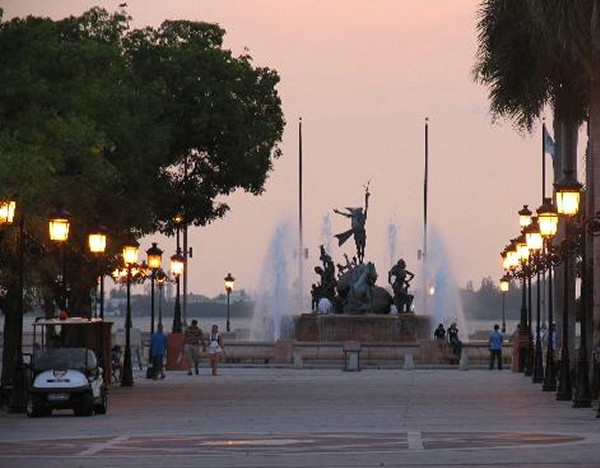
Paseo de la Princesa
Paseo de la Princesa skirts the curved walls of the old city,
greeting tourists with shops, cafes and a delicate fountain along
its shoreline path. One of the most pleasant San Juan attractions,
the street is a nice way to take in the Caribbean sun on an
afternoon stroll. Lined with flowers, statues, palm trees and all
sorts of things you'd expect on a stylish little street, Paseo de La
Princesa connects the port to the city gate.
From the path laid out by Paseo de la Princesa, Old San Juan shines.
The promenade is home to a large number of cultural events, and a
wealth of people enjoying the midday ritual of a glass of Piragua, a
tasty mix of ice and tropical fruit syrups. You definitely won't be
the only person drinking one.
Paseo de la Princesa Old San Juan offers views of nearby Isla de
Cabras that is home to an old Spanish prison. A fountain marks the
street's end. The prison is now home to Puerto Rico's tourism
headquarters. But the imposing fortress walls that line the street
seem unchanged since the day they were constructed. Much like the
nearby El Morro and the most popular San Juan attractions, this
street is steeped in the city's colonial history, with its 1600s
architecture fully preserved.
Another of the San Juan attractions found on Paseo de la Princesa is
the Racies/Roots Fountain. Full of bronze statues celebrating the
city's rich cultural heritage, it's often the stopping point for
couples and/or partiers, (depending on the time of night). The
terraced decks nearby are perfect to take in the ever-changing San
Juan scene, and are often the site of musical performances
throughout the week. Another attraction along the pathway is one of
the original six gated passageways, known as the Puerta de San Juan
- of the six, it's the only one remaining.
The Paseo de la Princesa has become such a staple of tourism in San
Juan that the promenade has been further developed in the past ten
years, offering wondrous looks of El Morro and panoramic views of
the port, rocky cliffs and the rest of the city. But it's the
original half of the pathway tracing the old city walls that brings
in the majority of tourists. Of all the attractions in the Old San
Juan, this is one of the most visited spots because what you see
changes with the time of the day. Whether it's the sunset
performances, sun-drenched views or midnight strolls that you would
like to see, the Paseo de la Princesa is a great place to get
acquainted with the city of San Juan.
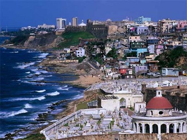
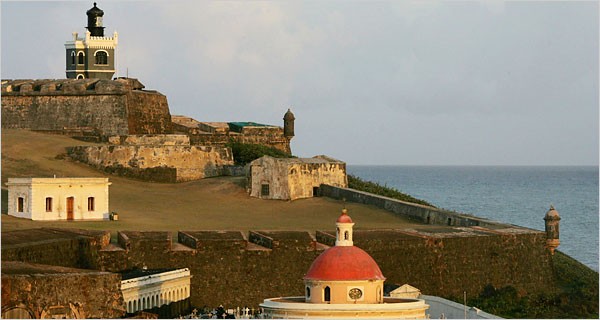
Forts
El Morro, the word itself sounds powerful and this six-level
fortress certainly is. Begun in 1540 and completed in 1589. San
Felipe del Morro was named in honor of King Phillip II. Most of the
walls in the fort today were added later, in a period of tremendous
construction from the 1760's-1780's. Rising 140 feet above the sea,
its 18-foot-thick wall proved a formidable defense. It fell only
once, in 1598, to a land assault by the Earl of Cumberland's forces.
The fort is a maze of tunnels, dungeons, barracks, outposts and
ramps. El Morro is studded with small, circular sentry boxes called
"garitas" that have become a national symbol.
The views of San Juan Bay from El Morro are spectacular. The area
was designated a National Historic Site in February of 1949 with 74
total acres. It has the distinction of being the largest
fortification in the Caribbean. In 1992, the fortress was restored
to its original historical form in honor of the 500th anniversary of
Christopher Columbus' discovery of Puerto Rico. El Morro Fortress is
a National Historic Site administered by the National Park Service.
The fort is open to the public daily from 9am to 5pm
Castillo de San Crist�bal (San Crist�bal Fort) is El Morro's partner
in the city's defense. Built in 1634 (completed in 1771), was
considered the Gibraltar of the West Indies. San Crist�bal was
supported by a massive system of outworks that provided defense in
depth and is one of the largest defenses ever built in the Americas.
It rose 150 feet, covering 27 acres of land. As if its size and
height weren't sufficient to intimidate enemies, its intricate
modular design was sure to foil them. A strategic masterpiece, it
features five independent units, each connected by moat and tunnel;
each fully self-sufficient should the others fall. Open daily from
9am to 6pm
The Fuerte San Ger�nimo (San Ger�nimo Fort) was built on the
opposite end of San Juan to strengthen the city's defenses. The fort
is located behind the Caribe Hilton Hotel, with small military
museum in Puerta de Tierra.
The Santa Elena Battery building with a long chimney-topped bunker
was the formal army storage area.
Parks
The Parque de las Palomas (pigeon park) is located at the top of the
city wall, this park overlooks the restored La Princesa Jail, now a
government office with an attractive art gallery. The park is the
perfect spot from which to enjoy a magnificent view of the harbor,
city and mountains.
The Mu�oz Rivera Park is an spacious ocean side park with large
trees, landscape gardens and wide walks, located on Jes�s T. Pi�ero
Avenue. The park is open Tues-Sun 9:00am - 5:00pm.
Other parks include: Mart� Coll Linera Park, and Central Park (with
facilities for jogging, baseball, calisthenics and tennis).
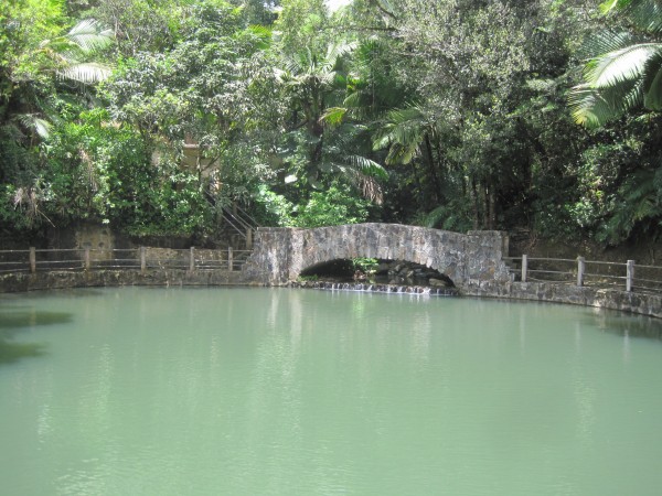
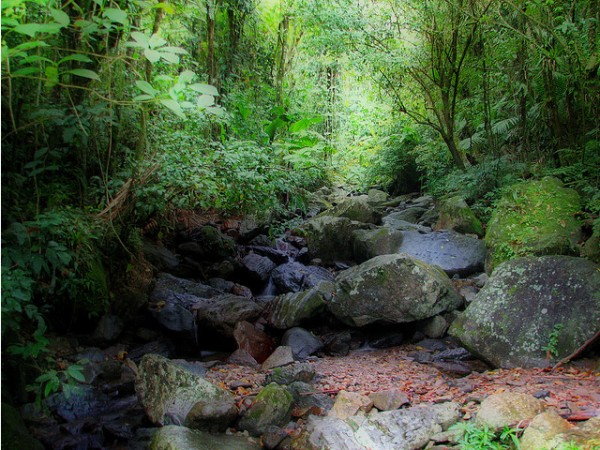
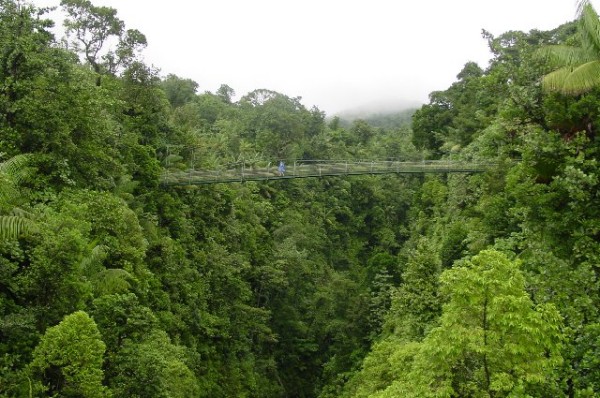
El Yunque Rain Forest
When you're in San Juan, don't miss the opportunity to witness the
pinnacle of natural beauty by exploring Puerto Rico's El Yunque Rain
Forest. It features more than 240 species of trees, hundreds of
miniature orchids, and what was once believed to be the Fountain of
Youth.
El Yunque Rainforest is located 25 miles southeast of San Juan. It
hosts a number of unique plant and animal species such as the
endangered Puerto Rican Parrot and the tiny coquis (indigenous tree
frogs) that serenade the evening hours. It is a very gentle forest.
In fact, there are no poisonous snakes! The El Yunque Rain Forest is
a cool, mountainous, sub tropical rainforest located on the Eastern
side of the Luquillo Mountains. The actual rainforest is at the top;
you must drive to the top of the road and hike up to see the cloud
or dwarf forest.
The intrigue of visiting the El Yunque rain forest is only partly in
the observation of the varieties of plants that have managed to grow
and adapt to the copious amounts of year round rainfall and winds
near the top. The magic of El Yunque is in the pristine beauty, the
sounds, the quietness and the serenity
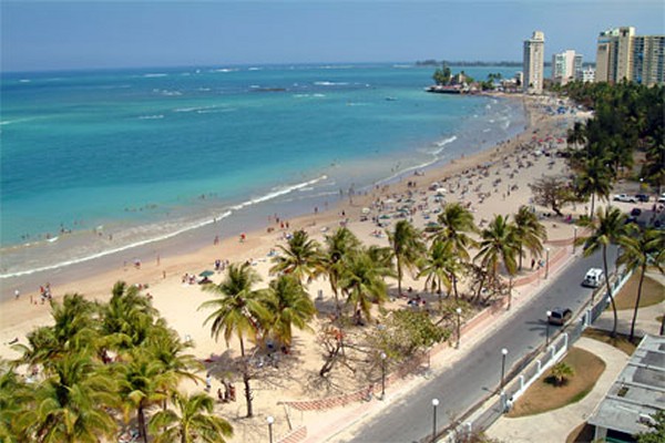
Condado Beach
El Condado, as the locals say, is the island's most glamorous
district, featuring boutiques, a variety of restaurants, and some of
the finest hotels on the island. Contrary to popular belief, many
nationals do reside here in the exquisite turn-of-the-century
mansions. You'll notice the populace on any given day to be a good
balance between tourists and locals. If you are an avid jogger,
you'll love the expanse of open area.
Isla Verde
Isla Verde is home to high-rise apartment buildings, huge clubs and
luxurious hotels. This area is actually part of the municipality of
Carolina, connected to San Juan via several highways and streets. It
spans from the Punta Las Mar�as area (adjacent to Ocean Park) to the
land just beyond the International Airport. Its nightlife is
exciting, and the enormous balneario, or public beach, is where
locals and guests come to sunbathe and get their fill of
people-watching.
Hato Rey
Hato Rey is several miles from Old San Juan but is easily
accessible. It is the island's central commercial district, where
the local wheelers and dealers conduct their business. Thus, its
restaurant scene caters to more business people than anywhere else
on the island. Roosevelt, the district's residential area, can be
found just off Highway 52. It is one of the most famous venues for
nightlife in San Juan, and the Plaza Las Americas, the Caribbean's
largest mall, is also located here.
Santurce/Miramar
Both the Santurce and Miramar districts are located just off Condado
and Old San Juan, but north of Hato Rey. Santurce was originally an
upper-class neighborhood and entertainment. Today, there are office
buildings and abandoned structures with a small but very good
marketplace (Plaza del Mercado). A major campaign is under way by
City Hall to restore the sector's vitality.
R�o Piedras
This district is known as University City because it houses the
University of Puerto Rico. Visiting R�o Piedras is enlightening for
those who want to explore the real Puerto Rico first-hand. The
district has a traditional Plaza del Mercado and a very hometown
atmosphere.
|
Old San Juan/Puerta de
Tierra
Paseo de la Princesa
El Morro Fortress
El Bano
Grande
El Yunque
Rain Forest

El Yunque
Rain Forest

El Yunque
Rain Forest
Hato Rey |
 |
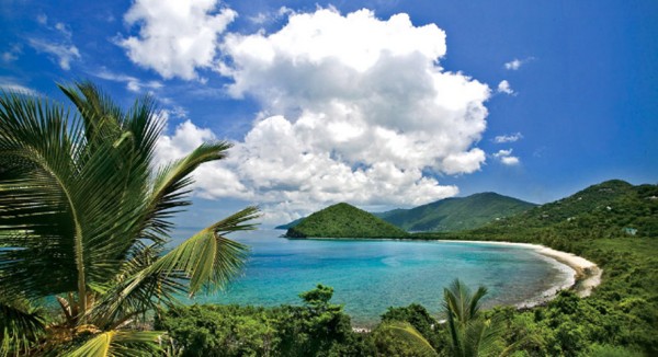
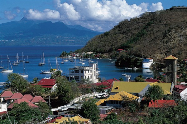
2 Tortola in the British Virgin Islands
|
|
Tortola, Capital City
and Yacht Paradise
Tortola is the sailing capital of the Caribbean's most popular
cruising destination.
An island of contrasts�from the hustle and bustle of the capital
Road Town, to the peace and tranquility of Sage Mountain national
park, to the beautiful un-crowded beaches� you'll find everything
you are searching for in Tortola.
Famed the world over for its spectacular sailing, the BVI's yachting
community congregate on Tortola and many a sailing adventure is
masterminded in the island's numerous bars and watering holes.
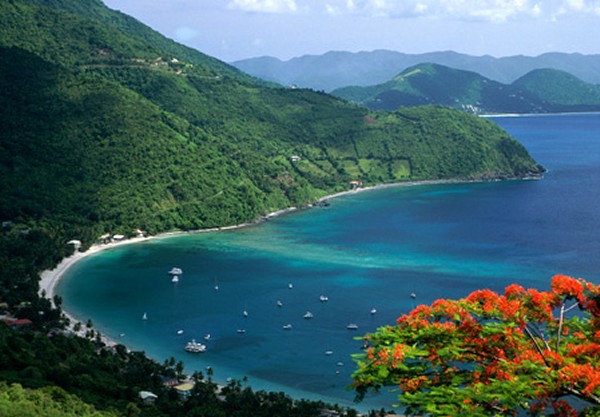
Cane Bay and
Smuggler's Cove
Tortola isn't just for yachters.
The bevy of beaches offered
by this charming island has left many a seasoned Caribbean traveler
speechless.
From Cane Garden Bay to Smugglers Cove and from Little Bay to
Lambert Beach this island has some seriously breathtaking beaches.
You can while away many an hour on these white, palm fringed
beauties - sipping cocktails or dipping your toes into the warm,
clear, blue waters.
After a tough day at the beach Tortola won't disappoint the hungry,
or thirsty visitor.
There are a huge array of watering holes and restaurants on this
island - whether you are looking for cocktails on the beach with
sand between your toes, or five star restaurants with gourmet food
and wine.
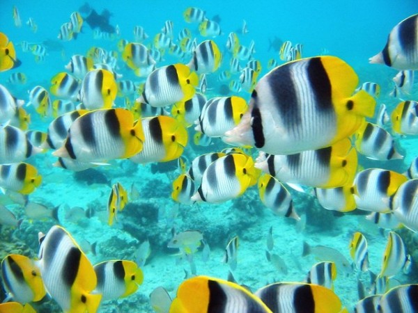
Snorkeling and Scuba
Swim with dolphins at Prospect Reef, head to Brewers Bay for some
excellent snorkeling, shop 'til you drop in Road Town for island
trinkets, jewelry and crafts or find your inner 'dude' and learn to
windsurf, kite surf or boogie board.
Tortola is fast becoming recognized as one of the Caribbean's top
dive spots. It has numerous dive sites for undersea exploration and
offers crystal clear waters, abundant sea life, stunning coral
gardens, canyons, tunnels, caverns, grottos, and shipwrecks.
Tortola provides a unique and visually stunning setting for
world-class diving. The outstanding underwater visibility,
year-round warm temperatures, healthy coral and wide variety of
exotic dive sites provides the ideal environment to enjoy this
underwater sport.
For real thrill-seekers there are a number of fascinating shipwrecks
lying scattered across the ocean floor around Tortola. If you're a
novice, discover the sheltered wreck of Chikuzen off Tortola's East
End, a 268-foot steel-hulled refrigerator ship. More advanced divers
can explore the Rhone off Salt Island, a British mail ship sunk in a
storm in 1867, generally recognized as the best dive site in the
Caribbean.
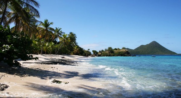
Tortola is home to some of the most scenic and untouched beaches in
the Caribbean. For surfers, boogie boarders or those that just love
to play in the waves, the beaches on the North Shore have the most
wave action. Despite the waves, the beaches on Tortola are
incredibly safe, having long steadily sloping sand banks where you
can walk right out and only find yourself waist deep!
Snorkeling is possible on most beaches although some have more
active coral and sea life than others.
Hiking Opportunities:
Beaches and Sage Mountain
If sailing the seas isn't your idea of fun,
there are many opportunities for walking and hiking in the BVIs.
For starters, take a walk on the beach.
Tortola beaches have been voted the "best beaches" by Caribbean
Travel and Life Magazine.
Tortola has plenty of
fun activities to offer the landlubber. Don your walking shoes and
hike up Sage Mountain to witness the traces of primeval rainforest
that can still be found.
Tortola offers the cool slopes of Sage Mountain National Park, where
traces of the primeval rain forest can still be seen at higher
elevations.
On its mountain ridge walkers can also observe local Caribbean life
with its gentle laid-back rhythms, farms, settlements, and churches.
The Mount Healthy National Park and Queen Elizabeth National Park
boast rock outcrops and vertical ghuts, or dry valleys, that expose
the deep, rich earth of this volcanic island.
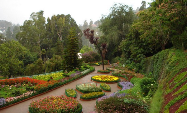
O'Neal Botanical Gardens
If something of a bit more leisurely walk is what you had in mind
then the J.R. O'Neal Botanic Gardens in Road Town offer peaceful
walks through pergolas and pathways covered with colorful vines, as
well as a miniature rain forest and fern house.
Shopping in Tortola is a bit of an adventure. There are no shopping
malls here, and familiar, multinational brand names are few and far
between.
What these islands do have are unique Caribbean crafts, surf and
beach wear in abundance, jewelry, island gifts and souvenirs.
Be prepared though to go hunting around the many small shops and
boutiques scattered across the island if you don't immediately find
what you are looking for.
Road Town, Tortola, is the main venue for island shopping. There are
a few jewelry stores around the cruise ship dock, offering a vast
and impressive selection. Also near the cruise ship dock is a Mill
Mall shopping centre.
Across from Waterfront Drive lies the old Main
Street of Road Town. This is an incredibly narrow, winding street that
is crammed with small tourist gift boutiques, restaurants, a coffee
shop, bakery, book shop, island jewelry stores, interiors shops and
much more.
It's well worth a wander down this road, which is quite
literally a trip down memory lane, and reminds us all how shopping
used to be. At the Western end of Main Street, you'll stumble on the
rear entrance to Pussers Road Town Pub and Store - a good place to
stop for a well-earned air conditioned break.
|
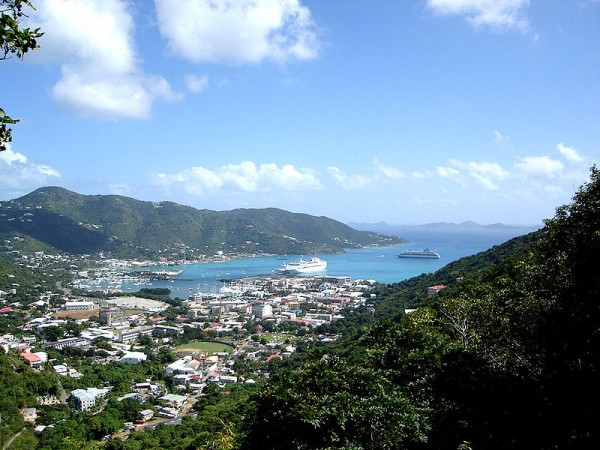
The Harbor of Tortola
Scuba and
Snorkeling Paradise
Cliffs at
Tortola
Smuggler's
Cove
Cane Bay |
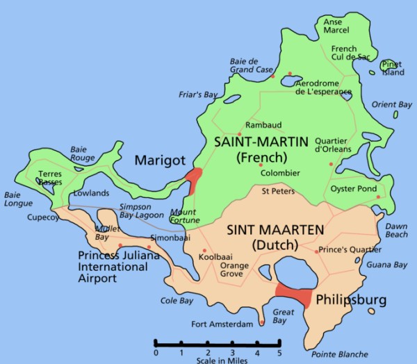
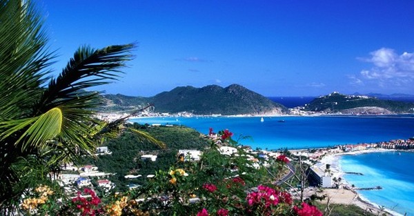
3
Philipsburg, Sint Maarten (St.
Martin)
|
|
Doctor Jekyll and
Mr. Hyde
This tiny little island is only about 15 miles
wide and 20 miles long, but still manages to have a split
identity... it belongs to two countries - France and the
Netherlands! How weird is that?
Even weirder, on four
different occasions, England owned the whole island. Three
languages are spoken here.
The Dutch control the
southern half with about 60% of the area while France controls the
north with the other 40%. Unlike other shared islands of the
world - Ireland, Timor, Cyprus - there is no violence or dispute.
There has been a spirit of friendship for the past 350 years.
The border is almost
imperceptible and people cross back and forth without ever realizing
they are entering a new country. All the same, each side has managed
to retain much of the distinctiveness of its own national culture.
For example, you can be walking down a street and the signs change
from French to Dutch... just kidding. That only happens in
Houston.
Oddly enough, there is
one other Caribbean island that is also shared by two countries.
Can you name it? Answer below.
Philipsburg is the capital of the island of St.
Maarten. Marigot is the capital of St. Martin,
the French side. The population of the two sides is virtually
the same. Surely they have fun with the annual soccer
championship match.
The Dutch side appears
to be more prosperous. Philipsburg is where our ship will
dock. It consists
of four parallel streets squeezed between
Great Bay, where the cruise ships dock, and Salt Pond, where salt
was made many years ago. The vision of a previous generation of
island leaders was to maintain the Creole
houses on the shore, providing arriving boats with a look back into
the island's past. For the most part, this has been done as the
larger hotels sit at the edges of town or just around the rocky
promontory that separates Great Bay from Little Bay.
The entire area has been improved greatly over the last few years.
The harbor was dredged so that cruise ships could tie up at a new
terminal. The sand from the dredging was used to replenish Great Bay
beach and a boardwalk was built running the length of the beach. In
addition, Front Street was beautified with paving stones, benches,
new sidewalks, palm trees, and cast iron streetlights. Parking was
eliminated, making the street a mile long shopping mall. New parking
was added along Pondfill and at Bobby's Marina at the same time.
Philipsburg may be only four streets deep and one mile long, but it
contains everything that anyone, and especially a tourist, needs.
All St Maarten is duty-free, but Philipsburg has shop after shop
each trying to outdo the others offering electronics, alcohol,
jewelry, linens, perfume, and more.
Are you a gambler?
Do you feel lucky? Find out
how your luck is running at any
of a number of casinos.
Restaurants abound. Some of the oldest and finest on the island are
here and the seafaring Dutch accepted waves of immigrants, obviously
there is fine French and Creole cuisine
but also Chinese and Indian. The boardwalk is lined with beach bars
some with hot dogs, some with high class. Take your pick.
Connecting Back Street, Front Street, and the Boardwalk are a series
of short side streets, typically jammed with small souvenir shops
and a few hidden cafes and restaurants. Many of the shops sell a
similar assortment of tropical shirts and bric-a-brac, but you also
can find mom-and-pop shops selling smooth flavored rums and Indian
crafts.
St. Martin is 144 miles southeast of Puerto Rico. At only 37 square
miles, this is the smallest land mass in the world to be divided
between two governments. In the early 1600's both the Dutch and the
French established small settlements on the island. They fought
together to prevent a Spanish invasion and decided to share the
island.
According to local folklore, the island was divided by a
walking contest between a Dutchman and a Frenchman. The Dutch
control 16 square miles, and the remaining 21 are under French
control. To this day, the Dutch still claim the
Frenchman cheated by running.
Duty-free shopping, 12 European style casinos, and lively
bars keep Philipsburg, the capital of Dutch St. Maarten, bustling
with activity.
As this is an island of 2 different countries, French is the
official language of St. Martin and Dutch is the official language
of St. Maarten, but the main language used on both sides of the
island is English. Currency in St. Maarten is the Netherlands
Antilles florin (the guilder) and it is the Euro in St. Martin, but
the US dollar is accepted on both sides. Stores will have prices
listed in both local currency and US currency, with change given in
like currency.
Everything from watches and jewelry to linens and swimwear can be
purchased on this duty-free island. Electrical products and Italian
leather goods are also "good buys". Some of the best prices in the
Caribbean can be found in St. Maarten. In fact, I found on numerous
visits that the liquor on St. Maarten is cheaper than in St. Thomas.
Be aware, however, that the same generous customs allowance
permitted for goods purchased in St. Thomas does not apply here.
Speaking of liquor, guavaberry, an island liqueur made with rum and
rare local berries, can be purchased at the Guavaberry Company and
makes for a unique island purchase.
This is another of the island gems that lends itself so well to
dividing your time between power shopping and lounging at a
world-class beach. You will find a wonderful visitor information
center right at the foot of the A.C. Wathey Pier where you can find
tours and local visitor information.
On the Dutch side, Simpson Bay and Mullet Bay are the most popular
beaches. Water sports equipment can be rented at Simpson Bay. For
convenience, Great Bay and Little Bay are right downtown, but do not
offer the most pristine conditions. Although there are numerous
beaches on the French side, Orient Beach stands out as stellar.
Alive with energy and activity, Orient Beach is the best location
for para-sailing, beach bars, people-watching and just limin'
("hanging out" Caribbean style beaches", this definitely makes the
top 10. Although Orient Beach is known as a clothing optional beach
(as are many beaches in Europe), it is very possible to spend the
day at Orient Beach without feeling the necessity to shed your
bathing suit.
The south end of Orient Beach, near Club O,
is reserved for naturists. If you venture to the other end of the
beach, it is very doubtful that you will encounter any nudity. If
water sports, such as windsurfing, kayaking, and jet-skiing,
snorkeling or diving do not interest you, then you can always try
your hand at a little black-jack at one of the European-style
casinos. Horseback riding, golf and hiking are other alternatives.
As for plain old-fashioned sight-seeing, a visit to the Butterfly
Farm provides an opportunity to see rare and exotic butterflies
amidst flowers, waterfalls and music.
Trivia Question
Answer: Haiti and the Dominican Republic share the island
of Hispaniola with Cuba and Puerto Rico as its neighbors.
However, unlike St Martin/Maarten, the Dominican Republic and Haiti
are no longer controlled by European interests. They are
countries, not territories. Unfortunately, the two countries
sharing the island don't get along well due to the extreme poverty
of Haiti. Unlike St Maarten/Martin, Hispaniola remains a troubled
island.
|
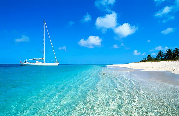
Island-Hopping with a sailboat
Great Bay
|
St. Kitts is short for St.
Christopher Island. About two and a half miles southeast lies
Nevis, the sister island. Together, they form an island nation
known as St. Kitts and Nevis. There doesn't appear to be a
bridge, but surely the ferry runs all day long.
St. Kitts is about twice as large.
Basseterre, which is located on St. Kitts, serves as the capital for
both islands. Although the official language is English, 90%
of the population is of African descent.
Like many of the Caribbean islands,
St. Kitts possesses
natural beauty, sunny
skies, warm waters, and white sandy beaches.
The entire population lives on the
coast. A dormant volcano in the middle of the island is so
steep that no one can live there. This mountain has an
interesting name - Mt. Misery -
Christopher
Columbus first spotted St. Kitts in 1493, when it was populated with
native tribes, but the Europeans didn't colonize until the British
arrived in 1623. Its strategic location and valuable sugar trade led
to an advanced and luxurious development that was among the best in
the Colonial Caribbean.
St. Kitts is unusual in its care for its natural
resources. This island that has set aside more than a quarter of its land
as a National Park. Its lovely rainforest is actually expanding in
size rather than shrinking.
An island surrounded
by new and untouched dive sites, marked by massive beds of coral,
teeming with fish of every stripe and color.
Vast, green, wind-furrowed sugarcane fields, a huge dormant volcano,
dense tropical forests, beautifully restored plantation homes
converted to inns and an abundance of wild, green, vervet monkeys,
brought to the island by French colonists, greet the visitor to St.
Kitts. This 65 square mile island was established in 1623 as
Britain's first colony in the West Indies.
In 1983, St. Kitts and
its tiny sister island, Nevis (2 miles away) became
independent nations. This easy-going island of unspoiled natural
beauty is a blend of sunlight, sea and abundant vegetation. The
picturesque capital, Basseterre, lies on the Caribbean shore near
the southern end of the island. Balconied white colonial houses
surround the central, octagonal Circus, designed in the style of
Piccadilly Circus.
Here you will be surrounded by wildlife, from chattering gray-green
monkeys and scurrying families of mongoose, to roaming cows, goats,
and black-bellied sheep.
Here you can drive or hike through the Valley of Giants, zip line
over the rainforest or climb up to sit yourself in the cradle of
Sofa Rock, once the very cap of a still smoldering volcano that you
can climb to the very edge of, then be guided down 1000 feet to its
steaming crater floor.
Once called the Gibraltar of the West Indies for its domination of
18th century battles, St. Kitts so honors its past with careful
restoration that the UN has designated Fort Brimstone a World
Heritage Site, and it is a living museum of historical exploration.
Most of the shopping is located at the Pelican Shopping Mall on Bay
Road, in Basseterre, or in the shops on Liverpool Row and Fort
Street. Souvenirs and local handicrafts, such as, island baskets and
leather (goatskin) goods are the best buys. Another popular item is
batik (cloth dyed using wax) found at Caribelle Batik at the Romney
Manor.
Take a short stroll around Basseterre. Wander around Independent
Square and the Circus, before making plans to venture to other parts
of the island. The top historical attraction is most definitely
Brimstone Hall fortress and well worth the trip about 9 miles
outside of town. Part of a national park, in addition to its
historical significance, provides breathtaking views of the
surrounding islands.
From there make sure to visit Romney Manor, home of Caribelle Batik.
This unique shopping/viewing experience should be high on your list
of priorities while in port. A day at the beach is always an option.
Banana Bay and Cockleshell Bay, lie side by side, and provide a
beautiful 2 mile stretch of white sand. Frigate Bay on the southeast
peninsula, near Basseterre, is another good choice. Here you can
enjoy horseback riding on the beach. Kayaking and hiking in the rain
forest are other active diversions. Perhaps one of the best
excursions is a 6 hour catamaran trip that visits Pinney's Beach in
neighboring Nevis. This 4 mile stretch of golden sand is the
location of the 4 Seasons Resort. Pinney's Beach on Nevis is one of
the grandest in the Caribbean. A lagoon that evokes the South
Pacific awaits near the beach's windward edge.
St. Kitts' beaches vary from black sand in the island's north, to
gray or white sand in the south. Friar's Bay Beach, a favorite of
many locals, is also good for families, thanks to its calm waters
and food stands. With its reef-protected waters, ideal for both
swimming and snorkeling.
Beyond the sandy beaches, natural attractions are abundant on both
islands. On St. Kitts, adventurous types hike up Mount Liamuiga
through the rain forest to the crater rim of a dormant volcano.
Among the trees of the cloud forest are a variety of rare birds, as
well as green vervet monkeys. Dive sites off the western coast of
Nevis vary from thermal vents to the high shoals near Booby Island,
where Southern stingrays and hawksbill turtles are found.
If you are a history buff, there are several historical sites to
visit.
St. George's Angelican Church
-- In the early stages of the French
occupation of Basseterre, a Roman Catholic Church, named Notre Dame,
was erected by the Jesuits. Notre Dame was burnt to the ground in
1706 during the Anglo-French War by English soldiers who were
billeted there. The Church was re-built by 1710 and re-named St.
George's. From the 1720's, it became a place of worship for the
Anglicans. It was damaged again in the fire of 1763, but once again
restored. The earthquake of 1842, followed by the hurricane of 1843,
reduced it to ruins, and an entirely new building was planned. But
the congregation continued to worship in the ruins until a new
church was consecrated on the 25th March, 1859. Seven years
afterwards, it was gutted in the Great Fire of 1867; and was
re-roofed, and restored in 1869. In a series of hurricanes since
1989, the church was again damaged but restoration work has since
been undertaken on the building.
Belmont Estate Yard
-- This former French property was less than 100
acres when Peter Brotherson acquired it early in the eighteenth
century. In 1726 the size increased when Brotherson petitioned for
additional lands adjoining his property. Sugar was extracted by
means of an animal mill for most of the eighteenth century. By 1828
the plantation extended to 286 acres, had a windmill, and was owned
by George Galway Mills. The size of the plantation increased to over
300 acres by the last quarter of the nineteenth century, when steam
technology was introduced. By then Stuart Davis owned the property.
In 1923 one of Stuart's descendants, Basil Davis, became General
Manager of the Central Factory in Basseterre. It was at this
plantation during the time of its occupancy by the Davis Family that
the incident that led to the 'Bull Story' occurred, an enactment
that has become a standard for Folk Performing groups of the island.
Today, an area manager occupies the estate house and the estate yard
is used in the system of management of the sugar industry now
operated by the Government owned Sugar Manufacturing Corporation.
Plans for the development of a Sugar Museum at Belmont Estate are
being discussed.
Romney Manor
Once owned by Sam Jefferson II, the great great
great grandfather of Thomas Jefferson (3rd President of U.S.A.) the
great house was renamed Romney Manor following its acquisition in
the early 17th century by the Earl of Romney. Its grounds have a
great history; there is strong evidence that they were originally
the site on which Tegereman the Carib Indian Chief had his village.
In 1834 contrary to the instructions of the British Parliament, Lord
Romney declared his slaves free men. Romney Estate therefore became
the first estate in St.Kitts to emancipate their slaves. Set in
approximately 10 acres of grounds, Romney was established in the
17th century and since then has only known 6 family owners. These
owners have witnessed the crushing of cane by animal power, wind
power and water power. Finally however, in the 1920's all cane
processing was centralised in Basseterre.
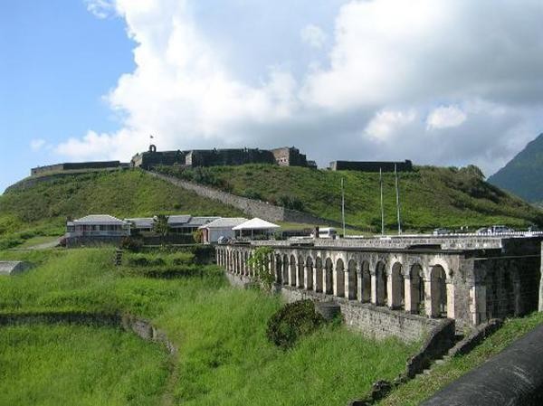
Brimstone Hill Fortress National Park
To get a breathtaking view of the best panorama in the Caribbean,
visit the Brimstone Hill Fortress on St. Kitts, which commands a
view of six islands: Nevis, Montserrat, Saba, St. Eustatius, St.
Martin and St. Barts. The St. Kitts Scenic Railway follows old sugar
cane tracks on a tour of the island's most spectacular scenery.
Journey through a rain forest and local villages on a hike or
mountain bike ride on Nevis' 9-mile Upper Round Road.
Brimstone Hill Fortress is a UNESCO World Heritage
Site of historical, cultural and architectural significance. Over
the course of 100 years, it became an almost natural outgrowth of
the 800-foot hill from which it emerged; a monument to the ingenuity
of the British military engineers who designed it and to the skill,
strength and endurance of the African slaves who built and
maintained it. The steep slopes of Brimstone Hill had to be tamed by
the disciplines of engineering and architecture, and at the risk and
probable loss of human lives. The walls of the structures are
predominantly of stone, laboriously and skillfully fashioned from
the hard volcanic rock of which the hill is composed. The mortar to
cement the stones was produced on site from the limestone that
covers much of the middle and lower slopes. Begun in the 1690s, the
Fortress finally took shape as a complete military community in the
1790s, and as such is it is a veritable time capsule of
international significance. What's more, the prominent Citadel is
one of the earliest and finest surviving examples of a new style of
fortification known as the polygonal system.
Take a
Railroad Trip
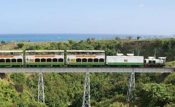
St. Kitts has one of the few remaining operational rail tracks in
the Caribbean. Begun in 1910 as part of the 20th Century
modernization thrust in the sugar industry, this narrow gauge
railway remains in use today. It runs around the major part of the
island, visiting several loading sites called 'sidings' at which the
harvested sugar cane was placed into carts. There are 24 bridges
that cross the ravines emanating from the island's central mountain
range. The antique locomotives, hauling up to 40 cane carts,
transported the cane to the central sugar factory located on the
outskirts of the main town of Basseterre.
The first tract of the
railway was laid between the port and the site for the factory, so
that material for the construction and equipping of the factory was
carried by rail. A collection of photographs taken during the
construction of the railway is kept at the Basseterre Public
Library.
Today the track is home to the St. Kitts Scenic Railway
Tour; this is obviously a fun way to see the
island.
|
From St. Kitts, you can see
its sister island Nevis

Romney Gardens
View from Romney Gardens
Brimstone Hill Fortress
 |
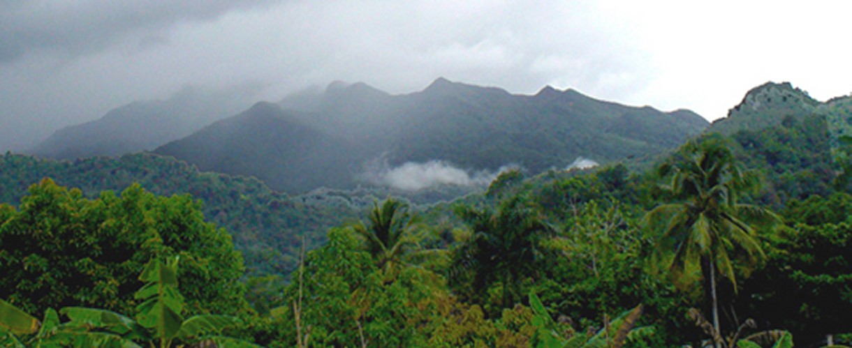
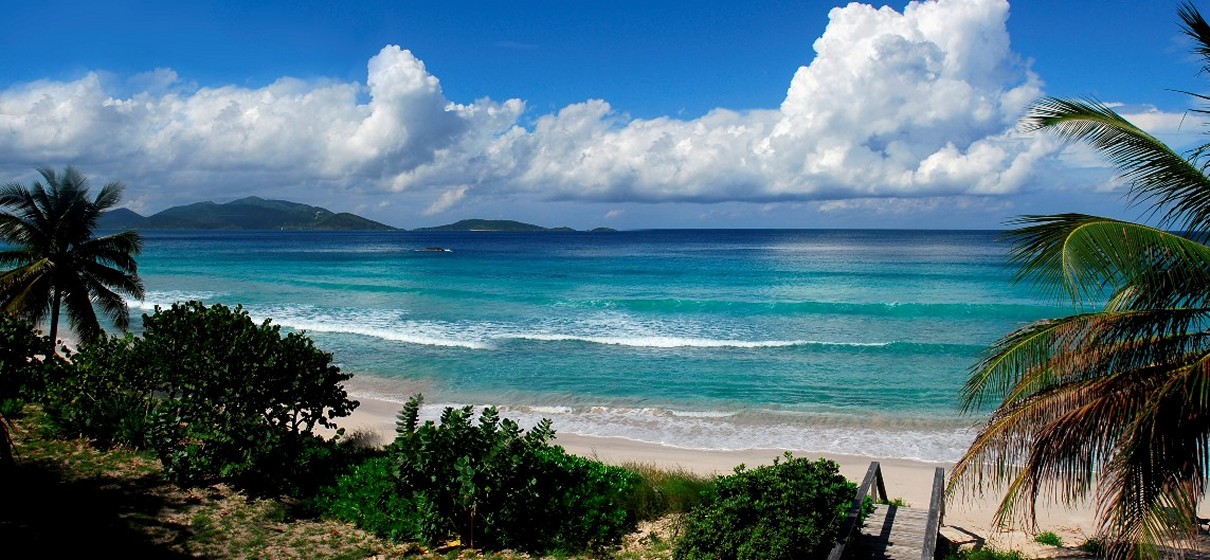
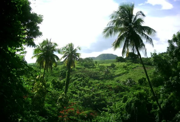
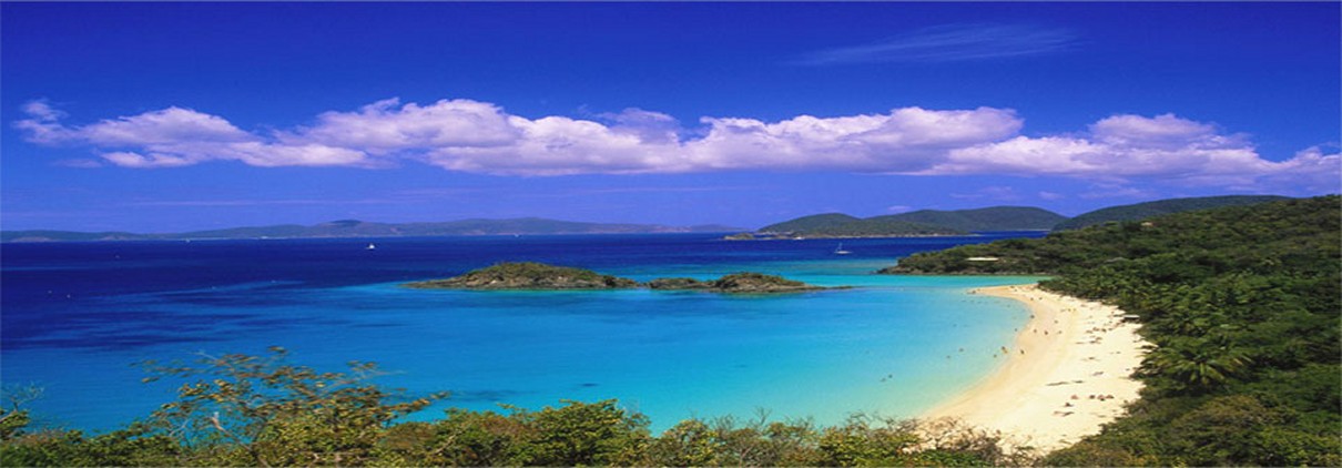
Dominica is the closest thing to a deserted
island that a cruise ship will ever find. Yes, there are
people there, but not many. As an example, Saint Martin,
another island we will visit, is 33 square miles with a population
of 80,000. Dominica is 290 square miles with a population of
70,000. Barbados, our next stop, is 166 square miles with an
estimated population of 284,589 people. You get the point.
Dominica small island nation that is known for its pristine
beauty and unspoiled nature. Roseau is the main city on Dominica
and serves as its capital.
The beaches are just as pretty as the other
islands, but the real treasure in Dominica is its hiking
trails, rivers and unique culture.
Dominica is different
from the other surrounding Caribbean islands due to its extremely
mountainous geography. This geography has played a major
factor in the island's development.
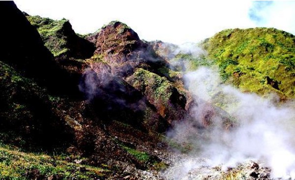
Nine of the Caribbean�s
sixteen active volcanoes are located on the island of Dominica.
Dominica�s nine active volcanoes are: Morne au Diable, Morne Trois
Pitons, Morne Diablotins, Morne Watts, Morne Anglais, Wotten Waven
Caldera, Valley of Desolation, Grande Soufriere Hills and Morne Plat
Pays.
Scientists are fairly
certain that one of them will blow its top in the next hundred
years. However, now that SSQQ is coming to visit, the
consensus is the next eruption will be sometime around Spring Break
in 2012.
Thanks to all its
mountains, Dominica was considered the toughest island to grow
crops. Consequently this island was ignored. On the
other hand, Barbados with its incredibly flat terrain was a real
favorite for sugarcane. That explains in a nutshell why
Barbados which is half the size of Dominica has four times the
population.
Dominica is home to
most of the remaining Carib Indians. The Caribs were
the natives of the Caribbean before Columbus and Spain brought
disease and murder to the islands.
There is a reason for
the high concentration of Carib Indians. As the Caribs kept
getting booted off the other islands like Barbados, they fled to
nearby Dominica. Dominica was pretty much their last refuge.
Nothing has changed
since those days. Dominica is still a tough place to grow
crops. Since many inhabitants of the islands grow their own
food, this fact has kept the population in Dominica small.
This also explains why
Dominica looks almost the same today as it did in the days of
Columbus three hundred years ago. The interior of Dominica
remains in virtually a pristine state. This means every
tourist is able to see stunning landscapes of incredible beauty.
Dominica is often called
the "Kauai of the Caribbean" due to its many breathtaking
waterfalls. Kauai, of course, is the rugged Hawaiian island
where Spielberg filmed Jurassic Park. Spielberg had to
helicopter in an entire crew to film a scene at Manawaiopuna Falls,
a location so inaccessible you can't drive there. When it
comes to waterfalls, Dominica with its 365 rivers has many
spectacular waterfalls of its own.
Roseau
The cruise ship will dock right in downtown Roseau at the Roseau
Cruise Ship Terminal within easy walking distance of downtown
Roseau.
Right off the ship you can explore the shopping areas of Roseau
starting just within the cruise terminal. Be sure to explore the Old
Market Plaza (once a slave trading market located next to the Roseau
Museum) and the boutiques found in and around it. There are many
local items to purchase that are wonderful reminders of Dominica.
Local rum, wood carvings, soaps, Caribbean music, leather goods,
baskets and other weaved items, lace items, silk screened materials
and batiks, as well as the more traditional tee shirts and other
souvenirs and collectibles.
Some of the boutiques offer art by local
artists that is excellent. Be sure to keep an eye out for some
exquisite pieces while exploring the shops. Several days a week the
Old Market Plaza turns into a farmer's market with plenty of fruits,
vegetables and flowers to please anyone and this is a great place to
pick up a flower arrangement for your cabin.
Exploring Roseau is always a fun way to spend some time, however it
is difficult to get into Dominica's more remote surroundings in a
short visit without taking a tour.
Marla's
Note: This is a port where I would suggest
joining my tour
if you want to explore the mountains, waterfalls and nature of
Dominica. Click
Dominica for
information.
Hiking and mountain climbing are good reasons to visit Dominica; its
flora is made unbelievably lush by frequent rainfall. Covered by a
dense tropical rainforest that blankets its mountain slopes,
including cloud-wreathed Morne Diablotin at 4,671 ft., it has
vegetation unique in the West Indies. The mountainous island is 29
miles long and 16 miles wide, with a total land area of 293 sq.
miles, much of which has never been seen by explorers. You'll find
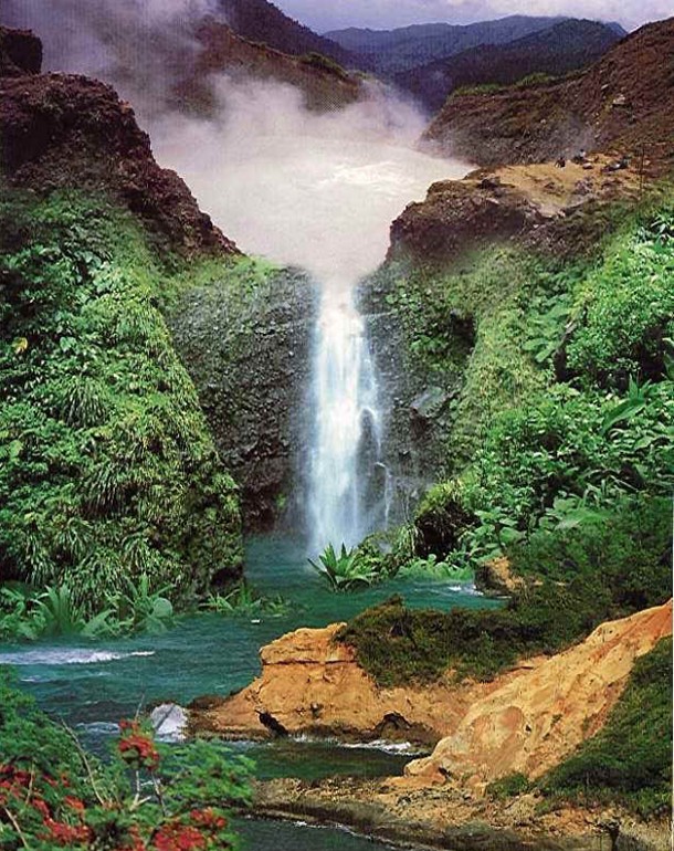
clear rivers, waterfalls, hot springs, and boiling lakes.
The most famous of hikes on Dominica is an advanced hike to the
"Boiling Lake", a deep blue lake with volcanic gases escaping from
it. If you elect to do this hike, buy it from the ship to make sure
that you get back in plenty of time. It is a three hour hike in and
the another three hours back out and if you are here for the day,
there is a good chance you could miss the ship if you are on your
own.
Morne Trois Pitons National
Park
It's like going back in time when you explore Morne Trois Pitons
National Park, a primordial rainforest. Mists rise gently over lush,
dark-green growth, drifting up to blue-green peaks that have earned
Dominica the nickname "Switzerland of the Caribbean." Framed by
banks of giant ferns, rivers rush and tumble, trees sprout orchids,
green sunlight filters down through trees, and roaring waterfalls
create a blue mist. One of the best starting points for a visit to
the park is the village of Laudat, 6 3/4 miles from Roseau.
The best tour is the Rain Forest Aerial Tram, at the corner of Old
Street and Great George Street in Laudat. For $65 per person, you're
taken on a 90-minute tour that starts at the village of Laudat,
"sailing" over the rainforest through the Morne Trois Pitons
National Park. Along the way, you're treated to exotic bird life,
beautiful waterfalls, and much tropical flora.
Five miles up from the Roseau River Valley, in the south-central
sector of Dominica, Trafalgar Falls is reached after driving through
the village of Trafalgar. Shortly beyond the hamlet of Trafalgar and
up a short hill, there's a little kiosk where you can hire a guide
to take you on the short walk to the actual falls. In all, allow
about 1 1/2 hours for the trip from Trafalgar to the falls. This is
the only road or pathway into the falls, and you'll have to approach
on foot, as the slopes are too steep for vehicles. After a 20-minute
walk past ginger plants and vanilla orchids, you arrive at the base,
where a trio of falls converges in a rock-strewn pool.
For another great way to spend half a day, head for the Papillote
Wilderness Retreat. The botanical garden alone is worth the trip, as
are the views of mountains and lush valleys. Near the main dining
terrace is a Jacuzzi-size pool, which is filled with the
mineral-rich waters of a nearby hot spring. Nonguests can use the
pool for $4.50. Bring sturdy walking shoes in addition to a bathing
suit.
You will want to see the Carib Indian Territory, in the northeast.
In 1903, Britain got the surviving Caribs to agree to live on 3,656
acres of land. Today this reservation is the last remaining turf of
the once-hostile tribe for whom the Caribbean was named. Today they
survive by fishing, growing food, and weaving baskets and vetiver-grass
mats, which they sell to the outside world. The baskets sold at
roadside stands make especially good buys
Or you can take a taxi to Champagne Beach for some sunshine and
snorkeling. Be aware the beach has small pebbles for sand, but the
water is excellent and the snorkeling fantastic.
A visit to the botanical gardens is also very interesting and well
worth the effort to get there and explore it. Head up Queen Mary
Street (below Mome Bruce Hill) to gain entrance to the park.
No visit to Roseau would be complete without visiting the Fort Young
Hotel. Constructed on the 1720 site of an old French Fort that was
captured by the British in 1761 when the original Fort Young started
construction, this hotel is Dominica's most notable structure.
|
Roseau
Botanical
Gardens
Wherever
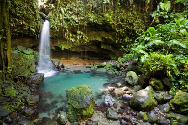
you go, you will see waterfalls.
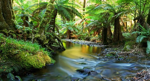
Dominica
is home to the most beautiful rainforest in the Caribbean
Suspension Bridge over Breakfast River Gorge
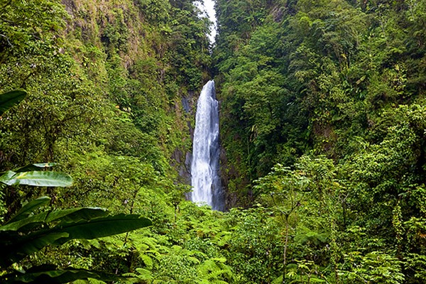
Trafalgar Falls
Marla's Note: I am planning a group shore
excursion into the rainforest which will include Trafalgar Waterfall
and Emerald Pool with a stop by the Botanical Gardens. For
more information,
click Dominica
|
 |
 |
Barbados is the easternmost island in the Lesser Antilles. It is
flat in comparison to its island neighbors to the west.
As a result, this island quickly became one of the world's largest sugarcane producer
starting in 1640. This brought startling wealth to this tiny
island. Around the time of the American Revolution, Barbados
was one of the three busiest ports in North America.
Even today, thanks in
large part to oil
production, along with the Caymans, Barbados enjoys one of the highest standards of living
of all the Caribbean islands.
Bridgetown, the capital of Barbados, is
one of the oldest cities in the Caribbean with enough to interest
the visitor for a few hours. Its architecture blends attractive,
balconied colonial buildings with warehouses and brash modern office
blocks. The centre of activity is the Careenage, a marina bordered
by the Barbadian parliament (home to two small but fascinating local
history museums). A number of the island's major religious buildings
are located within five minutes' walk of parliament, including St
Michael's Cathedral and a synagogue, both standing on the same sites
since the mid-seventeenth century.
Just north of the city, a couple of rum factories are open for
tours, while Tyrol Cot is an unusual nineteenth-century house that
was home to two of the island's leading post war politicians, Sir
Grantley Adams and his son Tom Adams. Southeast lies the historic
Garrison area where the British Empire maintained its Caribbean
military headquarters from 1780 to 1905 - its huge grassy savanna,
today a racecourse and public park, was once the army's parade
ground. The ranks of brightly colored military buildings around its
edge include the excellent Barbados Museum.
A little history of Bridgetown Barbados�The city was originally
founded by British settlers in 1628.
Upon arriving at a protected river inlet known as the Careenage, the
settlers found a small bridge across this river which they called
the Indian Bridge. It is believed that this bridge was built by The
Arawaks, indigenous people to the Caribbean. The bridge was then
rebuilt by the British later in 1654 and the Careenage became a
major hub for trading vessels.
The area eventually became known as Bridgetown and was the centre
for the first government of the Windward Islands of the Caribbean.
The bridge has since been replaced by a more modern lift bridge and
renamed The Chamberlain Bridge. Bridgetown is now the island's major
commercial and governmental centre.
The Careenage is no longer used for trading vessels as the
Bridgetown Shipping Port was later constructed. It is however now
home to many yachts and catamarans. Bridgetown is often referred to
as 'Town' by the locals and is our only major city.
The population of Bridgetown is about 97,000 with an area of 13.5
sq. miles. This is more than 1/3 of the entire island's population!
It is therefore a very small, dense and busy city.
The best way to explore this town is by foot and should only take a
few hours.
The main street of the town is Broad Street and is the perfect place
to start your tour. This is considered the main area to go shopping
in Bridgetown Barbados and it should take you a few hours to explore
the numerous duty free shops and craft stores along this street.
At the west end of Broad Street you will find St.Mary's Anglican
Church, the 2nd oldest church on the island, which was built in
1825.
As you travel east along this street you will come across a great
store to visit on Broad Street called Cave Shepherd. This is the
island's leading duty free shopping centre. You can pretty much find
anything here from souvenirs and beach wear to high end jewelry and
cosmetics.
Once you have reached the east end of Broad Street you will be in
the heart of the capital and should take a moment to take a few
pictures of the Barbados Parliament Building. There is a beautiful
clock tower attached to it.
Just to your right there are also some other tourist attractions in
Bridgetown you should consider taking a look at. These include
National Heroes Square, a tiny square built as a tribute to the
island's many heroes, as well as The War Memorial and Fountain
Gardens.
The Chamberlain Bridge will be just behind you along Wharf Street.
Here you will find docked the many yachts and catamarans aboard
which the Barbados sea turtle tours begin.
A stroll west along the beautiful boardwalk at this river inlet will
lead you to the Carlisle Wharf and Barbados Heliport. The
Barbados helicopter tours begin at this heliport.
During your stroll you will notice the HMBS Wiloughby Fort, the old
home of the Barbados Coast Guard Division of the Barbados Defence
Force.
A trip further west from here along Princess Alice Highway will lead
you past the Bridgetown Fishing Harbour and bring you to the
infamous Pelican Village.
This is a shopping village which offers visitors the widest
selection of Barbados handcrafts and art work. Here you can take a
rest, grab some local food at the Cou-Cou village restaurant and
wind down your foot tour of the city.
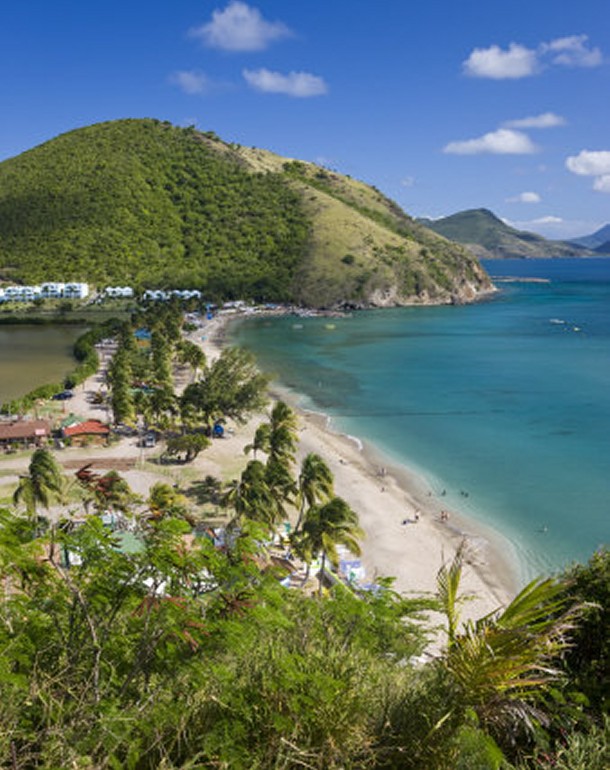
If you are a beach lover, Barbados beaches are some of the most
amazing white, sandy beaches in the Caribbean.
(Hmm... have we heard this before?)
The most well-known and best beaches in Barbados are situated along
the South and West coast of the island facing the calm Caribbean
Sea.
The North and East coasts, facing the rougher Atlantic Ocean, are
more dangerous and swimming at these beaches is highly discouraged.
The east coast is very popular with surfers.
Accra beach (also known as Rockley Beach) is by far the nicest and
most popular beach on the south coast of the island and is a
favorite amongst locals and visitors alike. Its popularity is due to
its stunning white sand and gentle yet playful waves
If you are looking for a beach with a peaceful atmosphere away from
the busier towns and luxury hotels then Miami Beach is the beach for
you.
Sandy Lane Beach is the most famous beach on the island. Located
along the calm west coast this magnificent crescent-shaped bay is
home to the luxurious Sandy Lane Hotel. So don't be surprised if you
spot some celebrities while taking a stroll.
Barbados is home to many
luxury hotels such as the Hilton seen pictured. With this
being the last our islands to visit, maybe this is the day to visit
a luxury hotel. Amidst the beauty of pool vistas and lush
foliage, you can lie back with a Daiquiri and give thanks for such a
great trip in such a beautiful part of the world.
|


|
 |
| |
|
|
About Royal
Caribbean's
Serenade of the Seas
This ship is a member of the Radiance-class. It is a
mid-sized ship, 90,000 tons with a 2100 passenger capacity.
It's most interesting distinction is the nearly three acres
of exterior glass employed in its design - including glass
elevators with ocean views - that incorporate the outdoors
quite beautifully onboard.
The effect is simply dazzling - and
there are remarkable views from nearly every public room.
The decorating scheme itself emphasizes elegance, grace, and
beauty, and creates quite a harmonious environment. The ship
is overflowing with glass and natural light, and the center
of it all is a ten-story all-glass atrium, that features
live music and dancing every evening.
|
In addition to the beauty, the ship
has a Rock Climbing Wall, Both Basketball and Volleyball
Courts, Golf Simulator, Day Spa and Fitness Center, Indoor
Solarium along with two Specialty Restaurants.
We sailed on the Serenade
on our May 2011 Virgin Islands
Cruise. This is a very beautiful ship; if you have any
doubts, check out our pictures from last
year's trip!
Group Hotel
Accommodations in San Juan
Marla's Note: In addition to the cruise, I will be offering both pre and
post group hotel packages in San Juan, Puerto Rico. More
info to follow shortly on our website.
Deposits
If you are interested in joining the adventure, please
complete the registration form ASAP. The $100 first deposit
will hold your space until the end of
October when the full deposit
of $250 will be due. Final payment is due by
December 20,
2011. Merry Christmas!
|
|
|
|